Welcome to Pigeon Island, a Tropical island in the Caribbean Sea, part of the majestic Atlantic Ocean. This guide offers a comprehensive overview of what makes Pigeon Island unique – from its geography and climate to its population, infrastructure, and beyond. Dive into the details:
Geography and size of Pigeon Island
Size: 0.221 km²
Coastline: 2.1 km
Ocean: Atlantic Ocean
Sea: Caribbean Sea
Continent: North America
Pigeon Island is a Tiny Island spanning 0.221 km² with a coastline of 2.1 km.
Archipel: Greater Antilles – A major island group in the Caribbean, including Cuba, Jamaica, Hispaniola, and Puerto Rico, known for their rich history and diverse cultures.
Tectonic Plate: Caribbean – Covering the Caribbean Sea and surrounding regions, this plate is bordered by the North American Plate and the South American Plate. Known for seismic activity, including earthquakes and volcanic eruptions, and features like the Puerto Rico Trench.
The geographic heart of the island is pinpointed at these coordinates:
Latitude: 17.79642034 / Longitude: -77.07399306
Climate and weather of Pigeon Island
Climate Zone: Tropical
Climate Details: Tropical Monsoon Climate
Temperature: Hot
Climate Characteristics: Characterized by heavy rainfall, high humidity, and uniformly high temperatures, but with a distinct short dry season. It features a seasonal reversal of prevailing wind directions.
Topography and nature of Pigeon Island
Timezone: UTC-05:00
Timezone places: America/New_York
Max. Elevation: -7 m
Mean Elevation: -8 m
Vegetation: Mangrove Forest
Tree Coverage: 97%
The mean elevation is -8 m. Remarkably, this unique island barely emerges above the sea level, showcasing nature’s fascinating interplay with the ocean. The island is characterized by Plains: Flat, low-lying lands characterized by a maximum elevation of up to 200 meters. On islands, plains are typically coastal lowlands or central flat areas.
Dominating Vegetation: Mangrove Forest
Found in coastal areas and river deltas, these unique wetland ecosystems are adapted to saline conditions and are crucial for coastal protection and biodiversity. Pigeon Island has a tree cover of 97 %.
Vegetation: 1 vegetation zones – Minimal Diversity Island
These islands exhibit the most basic level of ecological diversity, often characterized by a single dominant vegetation type. This could be due to extreme environmental conditions, limited land area, or significant human impact. They represent unique ecosystems where specific species have adapted to thrive in these singular environments.
Infrastructure and Travelling to Pigeon Island
Does the island have a public airport? no.
There is no public and scheduled airport on Pigeon Island. The nearest airport is Tinson Pen Airport, located 35 km away.
Does the island have a major port? no.
There are no major ports on Pigeon Island. The closest major port is ROCKY POINT, approximately 8 km away.
The mean population of Pigeon Island is 459 per km². Pigeon Island is Moderately Inhabited. The island belongs to Jamaica.
Continuing your journey, Jamaica is the next notable island, situated merely km away.
Things you need to know before you visit Pigeon island
Pack your slippers and come to this island for a unique experience! #weekendgetaway #pigeonisland #srilanka #sheneller ...Things you need to know before you visit Pigeon island
Pack your slippers and come to this island for a unique experience! ...
Pack your slippers and come to this island for a unique experience! #weekendgetaway #pigeonisland #srilanka #sheneller ...
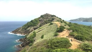
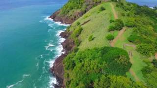
Pigeon Island National Park - Saint Lucia
Ces quelque 300 vidéos 4K sur les Caraïbes vous sont offertes par le ...
Why Pigeon Island St Lucia Is a Must-Visit!
On this tour of Pigeon Island National Park in St. Lucia, we show you ...
On this tour of Pigeon Island National Park in St. Lucia, we show you why it's a must-see when visiting the island of St. Lucia in the ...
Explore Pigeon Island on Saint Lucia
Get Lost with Kelley Ferro in Saint Lucia For an adventurous day ...
Get Lost with Kelley Ferro in Saint Lucia For an adventurous day activity with a side of history, hike up the lovely Pigeon Island.
Tom Does St. Lucia - Part 1 (Pigeon Island)
Put your walking shoes on. Tom has headed to St. Lucia and he is ...
Put your walking shoes on. Tom has headed to St. Lucia and he is determined to explore every inch of the island no matter the ...
What to do in St Lucia? Visit Pigeon Island National Park
What to do in St Lucia? Visit Pigeon Island National Park! One of the ...
What to do in St Lucia? Visit Pigeon Island National Park! One of the things not to miss when wondering what to do in #StLucia is ...
Underwater World 🐠🎏Pigeon Island | #pigeonisland #fishwatching #snorkeling #marinelife #jet
Swimming with Sharks in Sri Lanka - Pigeon Island Trincomalee
Why is Pigeon Island the only marine national park in Sri Lanka? we ...
Why is Pigeon Island the only marine national park in Sri Lanka? we traveled to Trincomalee to find out. Planning Your Trip ...
Pigeon Island Beach St. Lucia 🇱🇨 (Very unique beach!🏖️) 4K Walking Tour / Beach Walk & Review
Please SUB, LIKE, COMMENT & SHARE - Your appreciation makes us work ...
Please SUB, LIKE, COMMENT & SHARE - Your appreciation makes us work even harder. ✌️ SUBSCRIBE ...
Marella Voyager - St Lucia Pigeon Island
Pigeon Island St Lucia is a beautiful national park and historic site ...
Pigeon Island St Lucia is a beautiful national park and historic site offering stunning views, sandy beaches, and rich history.
Exploring Pigeon Island National Park
Ready to explore Sri Lanka's only aquatic national park, Pigeon ...
Ready to explore Sri Lanka's only aquatic national park, Pigeon Island? Here's what you need to know before you go! #SriLanka ...
Pigeon Island National Park Sri Lanka
Sri Lanka is popular for its two marine national parks, out of which ...
Sri Lanka is popular for its two marine national parks, out of which the Pigeon Island national park has always been the crowd ...
Pigeon Island Snorkel Site (St.Lucia, Caribbean)
Swimming with Black tip Sharks at Pigeon Island
blacktipshark #snorkeling #wildlife #nature #underwaterworld #oceanlife.
blacktipshark #snorkeling #wildlife #nature #underwaterworld #oceanlife.
Pigeon Island National Park Sri Lanka | Scuba Diving | Snorkeling |
Pigeon Island National Park is one of the two marine national parks of ...
Pigeon Island National Park is one of the two marine national parks of Sri Lanka. The national park is situated 1 km off the coast of ...
Pigeon Island National Park | Trincomalee | Sri Lanka | Travellers by Willrich
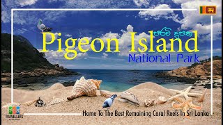
Pigeon Island National Park – Home To The Best Remaining Coral Reefs ...
Pigeon Island National Park – Home To The Best Remaining Coral Reefs In Sri Lanka. This is one of the two marine national ...
Pigeon Island: Best Snorkeling in SRI LANKA
In this travel vlog, we are visiting Pigeon Island National Park in ...
In this travel vlog, we are visiting Pigeon Island National Park in Trincomalee, Sri Lanka, which is in our opinion the best ...
Pigeon Island snorkeling sri lanka | පරවි දූපත | trincomalee | nilaveli beach #snorkeling #travel
Pigeon Island Discover the stunning beauty of Pigeon Island, a popular ...
Pigeon Island Discover the stunning beauty of Pigeon Island, a popular marine national park in Sri Lanka. Located off the coast of ...
Pigeon Island National Landmark: Exquisite from every angle
Televison commercial promoting the Pigeon Island National Landmark in ...
Televison commercial promoting the Pigeon Island National Landmark in Saint Lucia.
I Found Paradise in St. Lucia – Castries to Pigeon Island Beach! 🇱🇨
It's Sunday Funday, and what better way to spend it than at the beach? ...
It's Sunday Funday, and what better way to spend it than at the beach? The locals told me that Pigeon Island Beach aka Pigeon ...
Pigeon Island is a great place to learn beginner scuba diving training contact +94775111948
The best places for scuba diving in Trincomalee One of the most ...
The best places for scuba diving in Trincomalee One of the most popular of those places is Pigeon Island and the beautiful sea ...
Highlights of Saint Lucia - Beaches | Pigeon Island | Soufriere | Rodney Bay | Tet Paul | Nightlife
Planning your next island holiday? Saint Lucia is a great choice if ...
Planning your next island holiday? Saint Lucia is a great choice if you're looking for scenic beaches, hiking, authentic Caribbean ...
Swimming with sharks in Pigeon island Sri Lanka
Swimming with sharks in Pigeon island Sri Lanka.
Swimming with sharks in Pigeon island Sri Lanka.
Pigeon Island Beach #stlucia #caribbean #travel #beach #wanderlust
Jamaica is classified as Developing region: Regions characterized by lower income levels, with economies in the process of industrialization and modernization. The level of income is Upper middle income.
News – Latest Updates and Headlines from Pigeon Island
Stay informed with the most recent news and important headlines from Pigeon Island. Here’s a roundup of the latest developments.
Loading...
Please note: The data used here has been primarily extracted from satellite readings. Deviations from exact values may occur, particularly regarding the height of elevations and population density. Land area and coastline measurements refer to average values at mean high tide.