Welcome to Pogil-to, a Temperate island in the Japan Sea, part of the majestic Pacific Ocean. This guide offers a comprehensive overview of what makes Pogil-to unique – from its geography and climate to its population, infrastructure, and beyond. Dive into the details:
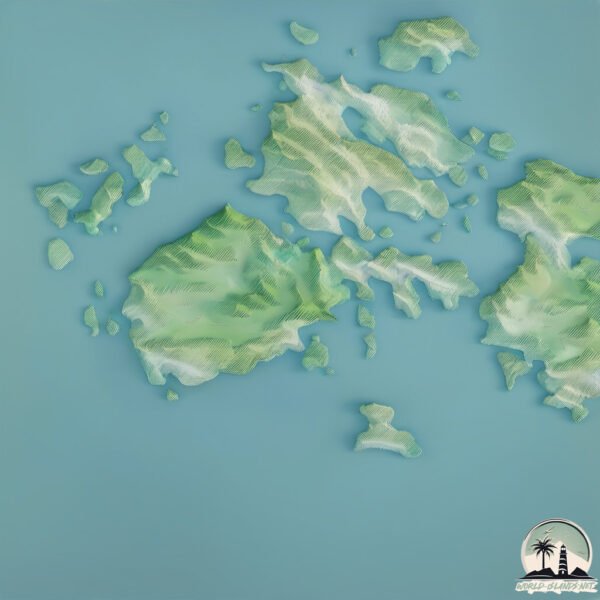
Geography and size of Pogil-to
Size: 34.3 km²
Coastline: 49.2 km
Ocean: Pacific Ocean
Sea: Japan Sea
Continent: Asia
Pogil-to is a Medium Island spanning 34 km² with a coastline of 49 km.
Archipel: –
Tectonic Plate: Amur – A minor tectonic plate in the region of the Amur River at the border of Russia and China, involved in complex interactions with the Pacific and Eurasian plates.
The geographic heart of the island is pinpointed at these coordinates:
Latitude: 34.15231839 / Longitude: 126.54728771
Climate and weather of Pogil-to
Climate Zone: Temperate
Climate Details: Humid Subtropical Climate
Temperature: Hot Summer
Climate Characteristics: With continuous rainfall and hot summers, this climate is common in some coastal regions, supporting diverse vegetation.
Topography and nature of Pogil-to
Timezone: UTC+09:00
Timezone places: Asia/Tokyo
Max. Elevation: 312 m
Mean Elevation: 116 m
Vegetation: Evergreen Broadleaf Forest
Tree Coverage: 67%
The mean elevation is 116 m. The highest elevation on the island reaches approximately 312 meters above sea level. The island is characterized by Hills: Gently sloping landforms with rounded tops, having a maximum elevation between 200 and 500 meters. Hills contribute to a varied landscape on islands.
Dominating Vegetation: Evergreen Broadleaf Forest
Characterized by dense, lush canopies of broadleaf trees that retain their leaves year-round. These forests are typically found in tropical and subtropical regions and are known for their high biodiversity. Pogil-to has a tree cover of 67 %.
Vegetation: 9 vegetation zones – Very Highly Diverse Island
Islands in this range are ecological powerhouses, showcasing a wide array of vegetation zones. Each zone, from lush rainforests to arid scrublands, coastal mangroves to mountainous regions, contributes to a complex and interdependent ecosystem. These islands are often hotspots of biodiversity, supporting numerous species and intricate ecological processes.
Infrastructure and Travelling to Pogil-to
Does the island have a public airport? no.
There is no public and scheduled airport on Pogil-to. The nearest airport is Jeju International Airport, located 68 km away.
Does the island have a major port? no.
There are no major ports on Pogil-to. The closest major port is CHEJU HANG, approximately 67 km away.
The mean population of Pogil-to is 82 per km². Pogil-to is Gently Populated. The island belongs to South Korea.
Continuing your journey, Soan-do is the next notable island, situated merely km away.
Bogildo, an Island Paradise in South Korea
To celebrate Korean Thanksgiving, my husband and I decided to book a pension with a hot tub and a nice beach. To our surprise ...Bogildo, an Island Paradise in South Korea
To celebrate Korean Thanksgiving, my husband and I decided to book a ...
To celebrate Korean Thanksgiving, my husband and I decided to book a pension with a hot tub and a nice beach. To our surprise ...
24HRS IN BOGILDO ISLAND KOREA | KOREA VLOG
In today's video we show you what we got up to when we spent 24hrs in ...
In today's video we show you what we got up to when we spent 24hrs in Bogildo Island, South Korea. Bogildo Island, is a tiny little ...
Abalone Farming In Bogil island
Wando Bogildo is an island in the Southern part of South Korea known ...
Wando Bogildo is an island in the Southern part of South Korea known for its production of seaweed products and its high quality ...
Bogildo in korea (island)☆☆
Southern part island.
Bogildo island/National Park in Korea/윤선도/보길도/세연정/동천석실/공룡알/황칠나무/예송리
Southern Island in Korea , (Bogildo) 땅끝마을에서 들어간 섬
2-Day Road Trip in Southern Part - Korea. (Ship a car)
[TV ZONE]Forest of Yun Seon-do in Bogildo Island -- Great Harmony with the Environment
A beautiful and elegant garden lies hidden among the mountains of ...
A beautiful and elegant garden lies hidden among the mountains of Bogildo, an island lapped by calm and serene waves. Known ...
Scenic Sites of Korea, Yun Seon do's Garden on Bogildo Island
보길도 윤선도 원림[Yun Seon-do's Garden on Bogildo Island,甫吉島 尹善道 園林] 전라남도 완도군 ...
보길도 윤선도 원림[Yun Seon-do's Garden on Bogildo Island,甫吉島 尹善道 園林] 전라남도 완도군 보길면 부황리에 있는 조선시대 ...
Shall we take a photo? A visit to Bogildo Island! [2Days & 1Night Season 3/2018.04.08]
Click the "Caption" button to activate subtitle! - Cast: Cha ...
Click the "Caption" button to activate subtitle! - Cast: Cha Taehyun(차태현), Kim Jongmin(김종민), Kim Junho(김준호), Defconn( ...
2Days & 1Night Season3 : Spring Trip to Bogildo Island Part 1 [ENG/THA/2018.04.08]
Click the "Caption" button to activate subtitle!! - Cast: Cha ...
Click the "Caption" button to activate subtitle!! - Cast: Cha Taehyun(차태현), Kim Jongmin(김종민), Kim Junho(김준호), Defconn( ...
보길도예송갯돌해변,The Island I want to visit in Korea
보길도를 다시가고픈 마음에 무더위를 무릅 쓰고 열심히 달려갔습니다. 예송리 해수욕장에 들러 멋진 펜션에서 옛추억을 떠올리며 ....
2025 완도 국제 청년 섬 워크 캠프 made by 이강륜
바다와 섬이 빚어낸 특별한 여행, 완도&보길도 청학동으로 떠나보자!! 이 아름다운 섬에는 김 체험, 전복 체험 등 다양한 자연 ...
바다와 섬이 빚어낸 특별한 여행, 완도&보길도 청학동으로 떠나보자!! 이 아름다운 섬에는 김 체험, 전복 체험 등 다양한 자연 문화 체험 ...
해남 보길도 Island ` Bogildo` Haenam korea
고산 윤선도 유적지의 섬 해남 보길도. 음악 : William Tell overture ( Rossini ).
BAC Island & Mountain 100 섬&산100 - 57. Bogildo - 보길도
BAC Island & Mountain 100 섬&산100.
2Days & 1Night Season3 : Spring Trip to Bogildo Island Part 2 [ENG/THA/2018.04.15]
Click the "Caption" button to activate subtitle!! - Cast: Cha ...
Click the "Caption" button to activate subtitle!! - Cast: Cha Taehyun(차태현), Kim Jongmin(김종민), Kim Junho(김준호), Defconn( ...
Road to Bogildo, Aging Island at Haenam Land (Sanyangjin Port) / 보길도 가는 길, 해남 땅끝에서 노화도(산양진항)
보길도가는방법 #해남땅끝선착장 #보길도여행 대한민국 지도를 보면 보길도가 얼마나 먼지 알 수 있다. 행정구역상으로는 전라남도 ...
WANDOrful Island in Bogildo❤️ #Abaloneworld #marstravel
It's a long-distance spring trip to an island ⛴️ [2Days & 1Night Season 3/2018.04.08]
Click the "Caption" button to activate subtitle! - Cast: Cha ...
Click the "Caption" button to activate subtitle! - Cast: Cha Taehyun(차태현), Kim Jongmin(김종민), Kim Junho(김준호), Defconn( ...
Harvesting abalone in Bogildo Island Wando County
Abalones, the world most expensive seafood farm here in Wando Bogil ...
Abalones, the world most expensive seafood farm here in Wando Bogil myeon South Korea sold live in tons.
Song Si-yeol writing rock on Bogil Island in South Korea
On the eastern side of Bogil Island, you can visit Song Si-yeol ...
On the eastern side of Bogil Island, you can visit Song Si-yeol writing rock to see the poem written on the rock. I was very lucky ...
김용빈 '내사랑 지금 어디':해남 땅끝에서 완도 보길도로 가는 길
해남 땅끝마을 선착장에서 완도 보길도를 가는 길에서 뒤돌아 본 땅끝마을과 전망대의 영상이다. 노래는 김용빈의 '내사랑 지금 어디' ...
보길도를 향하여 Toward Boggildo island
해남 땅끝마을에서 배를 탄다. Take a boat from Land end of Haenam. 첫번째 섬 노화읍을 차로 ...
해남 땅끝마을에서 배를 탄다. Take a boat from Land end of Haenam. 첫번째 섬 노화읍을 차로 지난다. Pass Nowha-eup the 1st ...
On the way to Bogildo island from the southern most tip of South Korea 10/24/2023
South Korea is classified as Emerging region: MIKT: Mexico, Indonesia, South Korea, and Turkey – Economies recognized for their development potential and emerging market status. The level of income is High income: OECD.
News – Latest Updates and Headlines from Pogil-to
Stay informed with the most recent news and important headlines from Pogil-to. Here’s a roundup of the latest developments.
Loading...
Please note: The data used here has been primarily extracted from satellite readings. Deviations from exact values may occur, particularly regarding the height of elevations and population density. Land area and coastline measurements refer to average values at mean high tide.