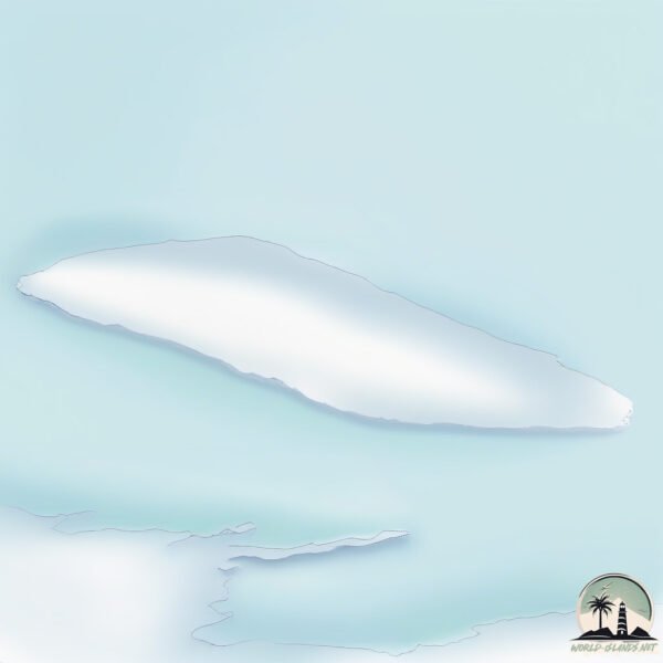
Welcome to Princess Thyra, a Polar island in the Greenland Sea, part of the majestic Arctic Ocean. This guide offers a comprehensive overview of what makes Princess Thyra unique – from its geography and climate to its population, infrastructure, and beyond. Dive into the details:
Geography and size of Princess Thyra
Size: 313.7 km²
Coastline: 78.4 km
Ocean: Arctic Ocean
Sea: Greenland Sea
Continent: North America
Princess Thyra is a Large Island spanning 314 km² with a coastline of 78 km.
Archipel: –
Tectonic Plate: North America – Covers North America and parts of the Atlantic and Arctic Oceans, characterized by diverse geological features and varying levels of seismic activity.
The geographic heart of the island is pinpointed at these coordinates:
Latitude: 81.95741284 / Longitude: -19.08763467
Climate and weather of Princess Thyra
Climate Zone: Polar
Climate Details: Tundra
Temperature: Cold
Climate Characteristics: The tundra climate features long, extremely cold winters and short, cool summers. Vegetation is limited to mosses, lichens, and small shrubs due to the low temperatures and short growing seasons. Biodiversity is low, but some specialized species thrive.
Topography and nature of Princess Thyra
Timezone: UTC-03:00
Timezone places: America/Sao_Paulo
Max. Elevation: 150 m
Mean Elevation: 67 m
Vegetation: Snow and Ice Covered
Tree Coverage: 58%
The mean elevation is 67 m. The highest elevation on the island reaches approximately 150 meters above sea level. The island is characterized by Plains: Flat, low-lying lands characterized by a maximum elevation of up to 200 meters. On islands, plains are typically coastal lowlands or central flat areas.
Dominating Vegetation: Snow and Ice Covered
These areas are permanently or seasonally covered in snow and ice, with little to no vegetation, such as polar regions and high mountains. Princess Thyra has a tree cover of 58 %.
Vegetation: 4 vegetation zones – Diverse Island
Four distinct vegetation zones mark these islands as ecologically diverse. They might feature varied landscapes such as forests, beaches, grasslands, and rocky areas. Such diversity reflects the island’s complex ecological interactions and varied habitats, which can support a rich array of wildlife and plant species.
Infrastructure and Travelling to Princess Thyra
Does the island have a public airport? no.
There is no public and scheduled airport on Princess Thyra. The nearest airport is Neerlerit Inaat Airport, located 1294 km away.
Does the island have a major port? no.
There are no major ports on Princess Thyra. The closest major port is SIGLUFJORHURD, approximately 1738 km away.
The mean population of Princess Thyra is 0 per km². Princess Thyra is Uninhabited. The island belongs to Denmark.
The name of the island resonates across different cultures and languages. Here is how it is known around the world: Arabic: جرينلاند; German: Grönland; Spanish: Groenlandia; French: Groenland; Portuguese: Gronelândia; Russian: Гренландия; Chinese: 格陵兰
Continuing your journey, Prinsesse Dagmar is the next notable island, situated merely km away.
Dark Secrets Of Princess Thyra, The Danish Royal Erased By Scandal
Hidden behind the glittering crowns and golden halls of 19th-century Europe lies one of the most haunting royal secrets ever ...Dark Secrets Of Princess Thyra, The Danish Royal Erased By Scandal
Hidden behind the glittering crowns and golden halls of 19th-century ...
Hidden behind the glittering crowns and golden halls of 19th-century Europe lies one of the most haunting royal secrets ever ...
Europe’s Richest Princess Marries Venezuelan Heir in Fairy-Tale Wedding 👑💎
Witness the fairy-tale wedding of Princess Marie Caroline, Europe's ...
Witness the fairy-tale wedding of Princess Marie Caroline, Europe's wealthiest royal, and Venezuelan heir Leopoldo Maduro ...
Princess Marie of Orleans, Princess of Denmark
Princess Marie Amélie Françoise Hélène d'Orléans (13 January 1865 – 4 ...
Princess Marie Amélie Françoise Hélène d'Orléans (13 January 1865 – 4 December 1909) was a French princess by birth and a ...
Travis and kids Playtime at the Beach
Travis, Ariana, Kaycee and Rachel first day at the beach!! Baby Travis ...
Travis, Ariana, Kaycee and Rachel first day at the beach!! Baby Travis played with his rakes and pails while Ariana took a nap ...
Tivoli Gondola Galop
Provided to YouTube by NAXOS of America Tivoli Gondola Galop · Tivoli ...
Provided to YouTube by NAXOS of America Tivoli Gondola Galop · Tivoli Symphony Orchestra · Tamás Vető Lumbye: Complete ...
Thyra [OC]//Rescue my heart (for StarkQueen)
A part for Starkqueen's OC collab: ...
Princess Lovisa "Sessan" of Sweden and Norway, Queen of Denmark
Louise Josephine Eugenie of Sweden (Swedish: Lovisa Josefina Eugenia; ...
Louise Josephine Eugenie of Sweden (Swedish: Lovisa Josefina Eugenia; 31 October 1851 – 20 March 1926) was Queen of ...
#2 Island
Watch in HD!! Our second collab is already here!! We hope you like it ...
Watch in HD!! Our second collab is already here!! We hope you like it and let us know your fav couples!!! Theme: a forbidden or ...
Little Prince Christian Carl's Waltz: Den lille Prins Christian Carls Vals (Little Prince...
Provided to YouTube by NAXOS of America Little Prince Christian Carl's ...
Provided to YouTube by NAXOS of America Little Prince Christian Carl's Waltz: Den lille Prins Christian Carls Vals (Little Prince ...
King Frederik VIII of Denmark
Sorry about the weird noises in the background; my cats were playing ...
Sorry about the weird noises in the background; my cats were playing and running around* King Frederick VIII of Denmark ...
Prince Achileas-Andreas VS Princess Louise Charming Transformation 👑 From Baby To 2022
Prince Achileas-Andreas VS Princess Louise Charming Transformation ...
My Least Favorite To Favorite Skeleton Arabians-Wild Horse Islands Roblox
In this video I'm showing off my skeleton Arabians ans ranking them ...
In this video I'm showing off my skeleton Arabians ans ranking them from least favorite to favorite NONE ARE FOR TRADE Even if ...
The Children of King Christian IX of Denmark
A tribute to the children of the blessed king Christian IX of Denmark. ...
A tribute to the children of the blessed king Christian IX of Denmark. He earned the nickname "Father in law of Europe" because of ...
It's Agnes Mae's 3rd Birthday Party | We had so much FUN!!
We have been looking forward to this for so long, It's Agnes Mae's, ...
We have been looking forward to this for so long, It's Agnes Mae's, our baby girls 3rd Birthday party!! Swimming pool, Garden toys, ...
DOMINIKANSKA VLOGG 2
Hej! Här är andra vloggen här ifrån Dominikanska där ni får se hur min ...
Hej! Här är andra vloggen här ifrån Dominikanska där ni får se hur min dag här har varit, hoppas ni gillar den!
Hilsen til Fredericianerne: Hilsen til Fredericianerne, Galop (Regards to the Fredericianians,...
Provided to YouTube by NAXOS of America Hilsen til Fredericianerne: ...
Provided to YouTube by NAXOS of America Hilsen til Fredericianerne: Hilsen til Fredericianerne, Galop (Regards to the ...
Escaping the City, Sailing to an Island - Ep. 199 RAN Sailing
Let's leave the city and sail to a little island! Join us as we do ...
Let's leave the city and sail to a little island! Join us as we do that and have an awesome sail to our destination. We are a Swedish ...
Dvorak in Leeds
Provided to YouTube by NAXOS of America Dvorak in Leeds · Sean Barrett ...
Provided to YouTube by NAXOS of America Dvorak in Leeds · Sean Barrett Life and Works: Dvorak (Siepmann) ℗ 2004 Naxos ...
DOMINIKANSKA DAG 1
Hej! I dagens vlogg får ni följa med hur min första dag här I ...
Hej! I dagens vlogg får ni följa med hur min första dag här I dominikanska republiken var, puss!
Die Zauberflote (The Magic Flute) , K. 620 (arr. J. Heidenreich for wind ensemble) : Act II: O...
Provided to YouTube by NAXOS of America Die Zauberflote (The Magic ...
Provided to YouTube by NAXOS of America Die Zauberflote (The Magic Flute) , K. 620 (arr. J. Heidenreich for wind ensemble) ...
Golden Valley, AZ
Golden Valley, Arizona with an ending in Old Town Kingman, AZ. Part of ...
Golden Valley, Arizona with an ending in Old Town Kingman, AZ. Part of an ongoing Mohave County series highlighting areas not ...
Theodore Roosevelt - Return from African Safari in 1910 - Part 5 of 7
TR returns from his African hunting trip through the countries of ...
TR returns from his African hunting trip through the countries of Sudan, France, Denmark, Norway, Germany, Great Britain, and ...
Denmark is classified as Developed region: nonG7: Developed economies outside of the Group of Seven, characterized by high income and advanced economic structures. The level of income is High income: OECD.
News – Latest Updates and Headlines from Princess Thyra
Stay informed with the most recent news and important headlines from Princess Thyra. Here’s a roundup of the latest developments.
Loading...
Please note: The data used here has been primarily extracted from satellite readings. Deviations from exact values may occur, particularly regarding the height of elevations and population density. Land area and coastline measurements refer to average values at mean high tide.


![Thyra [OC]//Rescue my heart (for StarkQueen)](https://i.ytimg.com/vi/BfizHJHv6Uo/mqdefault.jpg)