Principe
Welcome to Principe, a Tropical island in the Gulf of Guinea, part of the majestic Atlantic Ocean. This guide offers a comprehensive overview of what makes Principe unique – from its geography and climate to its population, infrastructure, and beyond. Dive into the details:
- Geography and Size: Explore the island’s size and location.
- Climate and Weather: Weather patterns and temperature.
- Topography and Nature: Uncover the natural wonders of the island.
- Infrastructure and Travelling: Insights on reaching, staying, and making the most of your visit.
- News and Headlines: Latest News.
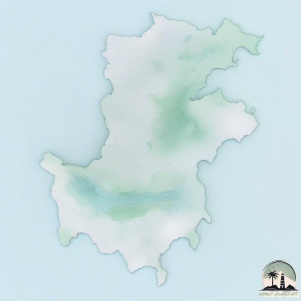
Geography and size of Principe
Size: 138.3 km²
Coastline: 86.5 km
Ocean: Atlantic Ocean
Sea: Gulf of Guinea
Continent: Africa
Principe is a Large Island spanning 138 km² with a coastline of 86 km.
Archipel: Cameroon Island Chain – A less-known archipelago off the coast of Cameroon, characterized by its biodiversity and cultural richness.
Tectonic Plate: Pacific – The world’s largest tectonic plate, covering much of the Pacific Ocean, known for the Pacific Ring of Fire with extensive seismic and volcanic activity.
The geographic heart of the island is pinpointed at these coordinates:
Latitude: 1.61532959 / Longitude: 7.39681834
Climate and weather of Principe
Climate Zone: Tropical
Climate Details: Tropical Monsoon Climate
Temperature: Hot
Climate Characteristics: Characterized by heavy rainfall, high humidity, and uniformly high temperatures, but with a distinct short dry season. It features a seasonal reversal of prevailing wind directions.
Topography and nature of Principe
Timezone: UTC±00:00
Timezone places: Europe/Lisbon
Max. Elevation: 740 m
Mean Elevation: 179 m
Vegetation: Evergreen Broadleaf Forest
Tree Coverage: 60%
The mean elevation is 179 m. The highest elevation on the island reaches approximately 740 meters above sea level. The island is characterized by Plateau: Elevated flatlands rising sharply above the surrounding area, with a maximum elevation over 500 meters but a mean elevation less than 300 meters, forming unique highland areas on islands.
Dominating Vegetation: Evergreen Broadleaf Forest
Characterized by dense, lush canopies of broadleaf trees that retain their leaves year-round. These forests are typically found in tropical and subtropical regions and are known for their high biodiversity. Principe has a tree cover of 60 %.
Vegetation: 11 vegetation zones – Exceptionally Diverse Island
Islands with more than ten vegetation zones are among the most ecologically rich and varied in the world. These islands are akin to miniature continents, boasting an incredible array of ecosystems. The sheer range of habitats, from high peaks to deep valleys, rainforests to deserts, creates a mosaic of life that is unparalleled. They are crucial for conservation and ecological studies.
Infrastructure and Travelling to Principe
Does the island have a public airport? yes.
Principe has a public and scheduled airport. The following airports are located on this island: Principe Airport.
Does the island have a major port? no.
There are no major ports on Principe. The closest major port is SANTO ANTONIO, approximately 1 km away.
The mean population of Principe is 59 per km². Principe is Gently Populated. The island belongs to São Tomé and Principe.
The name of the island resonates across different cultures and languages. Here is how it is known around the world: Arabic: برينسيبي; German: Príncipe; Spanish: Isla de Príncipe; French: Principe; Portuguese: Ilha do Príncipe; Russian: Принсипи; Chinese: 普林西比岛
Continuing your journey, Sao Tome is the next notable island, situated merely km away.
This Place is Out of This WORLD! PRINCIPE. UNKNOWN AFRICA


São Tomé and Principe is classified as Least developed region: Countries that exhibit the lowest indicators of socioeconomic development, with the lowest Human Development Index ratings. The level of income is Lower middle income.
News – Latest Updates and Headlines from Principe
Stay informed with the most recent news and important headlines from Principe. Here’s a roundup of the latest developments.
Please note: The data used here has been primarily extracted from satellite readings. Deviations from exact values may occur, particularly regarding the height of elevations and population density. Land area and coastline measurements refer to average values at mean high tide.