Welcome to Pulau Adanar, a Tropical island in the Arafura Sea, part of the majestic Indian Ocean. This guide offers a comprehensive overview of what makes Pulau Adanar unique – from its geography and climate to its population, infrastructure, and beyond. Dive into the details:
Geography and size of Pulau Adanar
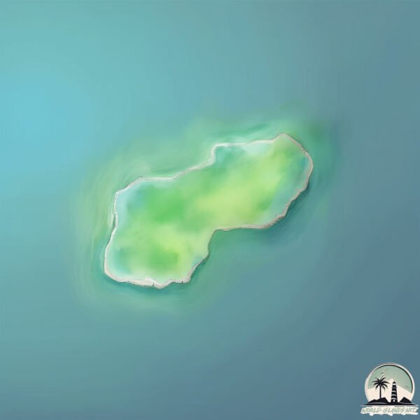
Size: 0.312 km²
Coastline: 2.5 km
Ocean: Indian Ocean
Sea: Arafura Sea
Continent: Oceania
Pulau Adanar is a Tiny Island spanning 0.312 km² with a coastline of 2.5 km.
Archipel: Melanesia – A subregion of Oceania in the southwestern Pacific Ocean, including countries like Fiji, Solomon Islands, and Vanuatu, known for their diverse cultures and languages.
Tectonic Plate: Timor – A small tectonic plate in the Timor region, primarily under the Timor Sea. It’s involved in the collision between the Australian and Eurasian plates, contributing to the region’s seismic activity and the uplift of the island of Timor.
The geographic heart of the island is pinpointed at these coordinates:
Latitude: -8.25969707 / Longitude: 130.91811143
Climate and weather of Pulau Adanar
Climate Zone: Tropical
Climate Details: Tropical Savanna, Wet
Temperature: Hot
Climate Characteristics: Defined by distinct wet and dry seasons with high temperatures year-round. Pronounced rainfall occurs during the wet season, while the dry season is marked by drought.
Topography and nature of Pulau Adanar
Timezone: UTC+09:00
Timezone places: Asia/Tokyo
Max. Elevation: -1 m
Mean Elevation: -4 m
Vegetation: Agricultural Mosaic
Tree Coverage: 71%
The mean elevation is -4 m. Remarkably, this unique island barely emerges above the sea level, showcasing nature’s fascinating interplay with the ocean. The island is characterized by Plains: Flat, low-lying lands characterized by a maximum elevation of up to 200 meters. On islands, plains are typically coastal lowlands or central flat areas.
Dominating Vegetation: Agricultural Mosaic
A mix of cropland and natural vegetation, often seen in rural landscapes where agricultural fields are interspersed with patches of natural habitats. Pulau Adanar has a tree cover of 71 %.
Vegetation: 1 vegetation zones – Minimal Diversity Island
These islands exhibit the most basic level of ecological diversity, often characterized by a single dominant vegetation type. This could be due to extreme environmental conditions, limited land area, or significant human impact. They represent unique ecosystems where specific species have adapted to thrive in these singular environments.
Infrastructure and Travelling to Pulau Adanar
Does the island have a public airport? no.
There is no public and scheduled airport on Pulau Adanar. The nearest airport is Mathilda Batlayeri Airport, located 65 km away.
Does the island have a major port? no.
There are no major ports on Pulau Adanar. The closest major port is SAUMLAKI, approximately 52 km away.
The mean population of Pulau Adanar is 27 per km². Pulau Adanar is Gently Populated. The island belongs to Indonesia.
Continuing your journey, Pulau Selaru is the next notable island, situated merely km away.
boss baby and Mimi,exploring at Adana island
boss baby and Mimi,exploring at Adana island
Visiting the Most Crowded Island on Earth (I can’t forget what I saw)
Santa Cruz del Islote has an area of just one percent of a square ...
Santa Cruz del Islote has an area of just one percent of a square kilometer in size where 816 people squeeze their entire lives.
Pulau Adana | Desa Lingat | Pulau Selaru | Maluku Tenggara Barat | 25 May 2016
Three months already since the day I came here.. and this is the most ...
Three months already since the day I came here.. and this is the most fabsssss so far . I walked in my 'shoes' and lived my life like ...
Top 10 Places to Visit in ADANA | 10 Amazing Places in Adana You Have to See !
In this video, we tried to explain to you in our video where to start ...
In this video, we tried to explain to you in our video where to start traveling to Adana? Where to go to travel in Adana? The 10 best ...
Panah Ikan di Pulau Adana - Pulau Selaru | Maluku Tenggara Barat (Mei 2016)
Cat island in Japan
Aoshima, nicknamed as Japan's cat island, is an island where only ...
Aoshima, nicknamed as Japan's cat island, is an island where only 15-20 residents live here but with more than 120 cats, about 6 ...
wisata pantai pulau adana desa lingat
TRIP TO SELARU ISLAND WITH JAKANGLER
Places in Maldives that don’t feel real #travel #explore #adventure #nature #maldives
Pulau Terselatan Indonesia #shorts
Pulau Terselatan Indonesia #shorts.
Pulau Terselatan Indonesia #shorts.
India geography:Map of Andaman and Nicobar|
geography ,#andman ,##nicobar,#india India geography:Map of Andaman ...
geography ,#andman ,##nicobar,#india India geography:Map of Andaman and Nicobar| Your Quories; andaman and nicobar ...
Bukan indonesia, ini negara dengan memiliki pulau terbanyak didunia
Bukan indonesia, ini negara dengan memiliki pulau terbanyak didunia ...
Bukan indonesia, ini negara dengan memiliki pulau terbanyak didunia Taukah kalian, jika negara Indonesia dikenal sebagai ...
The Lume by E&O | Andaman Island | Penang
Welcome to The Lume, a sanctuary of quiet luxury nestled on Andaman ...
Welcome to The Lume, a sanctuary of quiet luxury nestled on Andaman Island, Penang. Developed by E&O Group, this freehold, ...
Journey to a Hidden Abandoned ISLAND Mansion
Watch all episodes of Abandoned Spain Season 2 right here: ...
Watch all episodes of Abandoned Spain Season 2 right here: ...
Wisata di PULAU SETAN
Lokasi wisata pantai di kepulauan di Provinsi Sumatera Barat.
Lokasi wisata pantai di kepulauan di Provinsi Sumatera Barat.
Negara ini mempunyai pulau terbanyak!!! #shorts #swedia
Swedia di nobatkan sebagai negara yang mempunyai pulau terbanyak di ...
Swedia di nobatkan sebagai negara yang mempunyai pulau terbanyak di dunia dengan total pulau sebanyak 267.570, Dari total ...
Inilah penampakan Kelelawar raksasa penghuni hutan larangan|Pulau Nusa Gede|situ lengkong
Kawasan Hutan Nusa Gede, yg dihuni ribuan kelelawar raksasa. Panjalu ciamis.
Kawasan Hutan Nusa Gede, yg dihuni ribuan kelelawar raksasa. Panjalu ciamis.
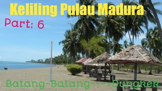
Keliling Pulau Madura dari ujung barat ke ujung timur. Part: 6 // Batang-Batang ------Dungkek
Di video keliling Pulau Madura part: 6 ini, kami mulai melintasi ...
Di video keliling Pulau Madura part: 6 ini, kami mulai melintasi wilayah kecamatan Dungkek, kecamatan paling timur di Pulau ...
keliling pulau Madura dari ujung barat ke ujung timur. Part: 5 // Pesisir Timur laut Sumenep
Di video keliling pulau Madura part:5 ini kami menyusuri jalur Timur ...
Di video keliling pulau Madura part:5 ini kami menyusuri jalur Timur laut dari pulau Madura yang cukup sepi dan terpelosok.
7 Pulau Terindah di Indonesia
Jangan Lupa Subscribe gais.
Jangan Lupa Subscribe gais.
The CRAZIEST Moments in Larva Island! | Netflix Family
There's always something wild, crazy, and fun happening on Larva ...
There's always something wild, crazy, and fun happening on Larva Island! Now streaming on Netflix! SUBSCRIBE: ...
Thomas meets Douglas in Project g1 ☢️😱 #thomasanimation
Please subscribe, like and poor Douglas #Shorts #ThomasTheTankEngine ...
Please subscribe, like and poor Douglas #Shorts #ThomasTheTankEngine #ThomasAnimation.
Ikan nemo dan sarangnya di pulau rubiah #pulauweh #nemo #anemon #sabang #aceh #wonderfulindonesia
Madura, keliling pulau dari ujung barat ke ujung timur. // Part 3: Tanjung Bumi ke Batulenger
Keliling pulau Madura part: 3 ini saat kami melintas di daerah Tanjung ...
Keliling pulau Madura part: 3 ini saat kami melintas di daerah Tanjung Bumi, bangkalan hingga sampai daerah Batulenger, ...
Pulau Nustabun, Kabupaten Maluku Tenggara Barat, Indonesia
Indonesia is classified as Emerging region: MIKT: Mexico, Indonesia, South Korea, and Turkey – Economies recognized for their development potential and emerging market status. The level of income is Lower middle income.
News – Latest Updates and Headlines from Pulau Adanar
Stay informed with the most recent news and important headlines from Pulau Adanar. Here’s a roundup of the latest developments.
Loading...
Please note: The data used here has been primarily extracted from satellite readings. Deviations from exact values may occur, particularly regarding the height of elevations and population density. Land area and coastline measurements refer to average values at mean high tide.