Pulau Bahubulu
Welcome to Pulau Bahubulu, a Tropical island in the Banda Sea, part of the majestic Pacific Ocean. This guide offers a comprehensive overview of what makes Pulau Bahubulu unique – from its geography and climate to its population, infrastructure, and beyond. Dive into the details:
- Geography and Size: Explore the island’s size and location.
- Climate and Weather: Weather patterns and temperature.
- Topography and Nature: Uncover the natural wonders of the island.
- Infrastructure and Travelling: Insights on reaching, staying, and making the most of your visit.
- News and Headlines: Latest News.
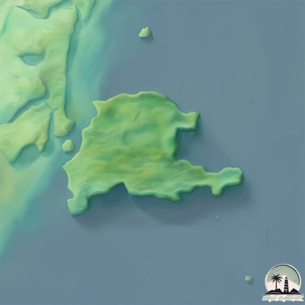
Geography and size of Pulau Bahubulu
Size: 32.7 km²
Coastline: 36.8 km
Ocean: Pacific Ocean
Sea: Banda Sea
Continent: Asia
Pulau Bahubulu is a Medium Island spanning 33 km² with a coastline of 37 km.
Archipel: Greater Sunda Islands – A group of large islands in Southeast Asia, including Borneo, Sumatra, Java, and Sulawesi, known for their rich biodiversity and cultural diversity.
Tectonic Plate: Maoke – A minor tectonic plate located in the western Pacific Ocean, mostly beneath the Maoke Mountains in Indonesia’s Papua province. It is involved in the region’s complex tectonic interactions, contributing to the area’s notable seismic activity.
The geographic heart of the island is pinpointed at these coordinates:
Latitude: -3.55998216 / Longitude: 122.31475088
Climate and weather of Pulau Bahubulu
Climate Zone: Tropical
Climate Details: Tropical Rainforest Climate
Temperature: Hot
Climate Characteristics: This climate is typified by heavy rainfall throughout the year, high humidity, and consistently high temperatures, leading to lush rainforests and rich biodiversity. Seasonal temperature variations are minimal.
Topography and nature of Pulau Bahubulu
Timezone: UTC+08:00
Timezone places: Australia/Perth
Max. Elevation: 442 m
Mean Elevation: 171 m
Vegetation: Evergreen Broadleaf Forest
Tree Coverage: 89%
The mean elevation is 171 m. The highest elevation on the island reaches approximately 442 meters above sea level. The island is characterized by Hills: Gently sloping landforms with rounded tops, having a maximum elevation between 200 and 500 meters. Hills contribute to a varied landscape on islands.
Dominating Vegetation: Evergreen Broadleaf Forest
Characterized by dense, lush canopies of broadleaf trees that retain their leaves year-round. These forests are typically found in tropical and subtropical regions and are known for their high biodiversity. Pulau Bahubulu has a tree cover of 89 %.
Vegetation: 5 vegetation zones – Highly Diverse Island
With five different vegetation zones, these islands offer a rich tapestry of ecosystems. The variety could include dense forests, open meadows, wetlands, coastal zones, and more. This level of diversity supports an intricate web of life, with each zone playing a vital role in the overall ecological health and balance of the island.
Infrastructure and Travelling to Pulau Bahubulu
Does the island have a public airport? no.
There is no public and scheduled airport on Pulau Bahubulu. The nearest airport is Haluoleo Airport, located 56 km away.
Does the island have a major port? no.
There are no major ports on Pulau Bahubulu. The closest major port is KENDARI, approximately 49 km away.
The mean population of Pulau Bahubulu is 10 per km². Pulau Bahubulu is Gently Populated. The island belongs to Indonesia.
The name of the island resonates across different cultures and languages. Here is how it is known around the world: Arabic: سولاوسي; German: Sulawesi; Spanish: Célebes; French: Célèbes; Portuguese: Celebes; Russian: Сулавеси; Chinese: 苏拉威西岛
Continuing your journey, Pulau Labengke is the next notable island, situated merely km away.
Pulau Labengki, Surga Tersembunyi di Konawe Utara | Nusantara Terkini tvOne


Indonesia is classified as Emerging region: MIKT: Mexico, Indonesia, South Korea, and Turkey – Economies recognized for their development potential and emerging market status. The level of income is Lower middle income.
News – Latest Updates and Headlines from Pulau Bahubulu
Stay informed with the most recent news and important headlines from Pulau Bahubulu. Here’s a roundup of the latest developments.
Please note: The data used here has been primarily extracted from satellite readings. Deviations from exact values may occur, particularly regarding the height of elevations and population density. Land area and coastline measurements refer to average values at mean high tide.