Pulau Batanglampe
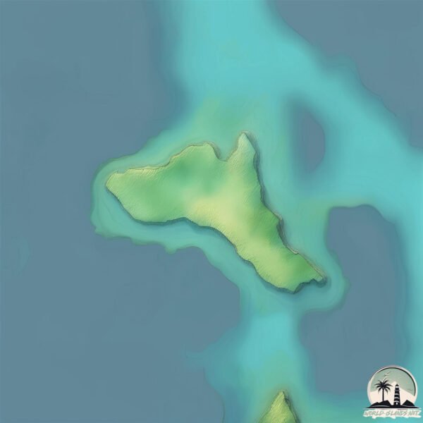
Welcome to Pulau Batanglampe, a Tropical island in the Gulf of Boni, part of the majestic Pacific Ocean. This guide offers a comprehensive overview of what makes Pulau Batanglampe unique – from its geography and climate to its population, infrastructure, and beyond. Dive into the details:
- Geography and Size: Explore the island’s size and location.
- Climate and Weather: Weather patterns and temperature.
- Topography and Nature: Uncover the natural wonders of the island.
- Infrastructure and Travelling: Insights on reaching, staying, and making the most of your visit.
- News and Headlines: Latest News.
Geography and size of Pulau Batanglampe
Size: 0.822 km²
Coastline: 4.8 km
Ocean: Pacific Ocean
Sea: Gulf of Boni
Continent: Asia
Pulau Batanglampe is a Tiny Island spanning 0.822 km² with a coastline of 4.8 km.
Archipel: Greater Sunda Islands – A group of large islands in Southeast Asia, including Borneo, Sumatra, Java, and Sulawesi, known for their rich biodiversity and cultural diversity.
Tectonic Plate: Sunda – Extends across Southeast Asia, encompassing parts of the Sunda Shelf, known for its interaction with the Australian Plate, contributing to volcanic activity in Indonesia.
The geographic heart of the island is pinpointed at these coordinates:
Latitude: -5.05242858 / Longitude: 120.42015798
Climate and weather of Pulau Batanglampe
Climate Zone: Tropical
Climate Details: Tropical Savanna, Wet
Temperature: Hot
Climate Characteristics: Defined by distinct wet and dry seasons with high temperatures year-round. Pronounced rainfall occurs during the wet season, while the dry season is marked by drought.
Topography and nature of Pulau Batanglampe
Timezone: UTC+08:00
Timezone places: Australia/Perth
Max. Elevation: 21 m
Mean Elevation: 13 m
Vegetation: Open Woodland
Tree Coverage: 79%
The mean elevation is 13 m. The highest elevation on the island reaches approximately 21 meters above sea level. The island is characterized by Plains: Flat, low-lying lands characterized by a maximum elevation of up to 200 meters. On islands, plains are typically coastal lowlands or central flat areas.
Dominating Vegetation: Open Woodland
Characterized by sparsely distributed trees with open canopy allowing sunlight to penetrate, supporting grasses and shrubs underneath. Often found in drier or transitional environments. Pulau Batanglampe has a tree cover of 79 %.
Vegetation: 3 vegetation zones – Moderately Diverse Island
These islands start to show a broader range of ecological niches. With three vegetation zones, they may offer a mix of ecosystems like coastal areas, inland woods, and perhaps a distinct wetland or dry area. This diversity supports a wider range of flora and fauna, making these islands more ecologically complex than those with minimal diversity.
Infrastructure and Travelling to Pulau Batanglampe
Does the island have a public airport? no.
There is no public and scheduled airport on Pulau Batanglampe. The nearest airport is Hasanuddin International Airport, located 95 km away.
Does the island have a major port? no.
There are no major ports on Pulau Batanglampe. The closest major port is UJUNG PANDANG, approximately 113 km away.
The mean population of Pulau Batanglampe is 298 per km². Pulau Batanglampe is Moderately Inhabited. The island belongs to Indonesia.
Continuing your journey, Salayar is the next notable island, situated merely km away.
Pulau 9 ( Batang Lampe )


Indonesia is classified as Emerging region: MIKT: Mexico, Indonesia, South Korea, and Turkey – Economies recognized for their development potential and emerging market status. The level of income is Lower middle income.
News – Latest Updates and Headlines from Pulau Batanglampe
Stay informed with the most recent news and important headlines from Pulau Batanglampe. Here’s a roundup of the latest developments.
Please note: The data used here has been primarily extracted from satellite readings. Deviations from exact values may occur, particularly regarding the height of elevations and population density. Land area and coastline measurements refer to average values at mean high tide.