Welcome to Pulau Baun, a Tropical island in the Arafura Sea, part of the majestic Indian Ocean. This guide offers a comprehensive overview of what makes Pulau Baun unique – from its geography and climate to its population, infrastructure, and beyond. Dive into the details:
Geography and size of Pulau Baun
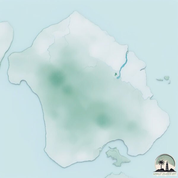
Size: 109.1 km²
Coastline: 57.9 km
Ocean: Indian Ocean
Sea: Arafura Sea
Continent: Oceania
Pulau Baun is a Large Island spanning 109 km² with a coastline of 58 km.
Archipel: Melanesia – A subregion of Oceania in the southwestern Pacific Ocean, including countries like Fiji, Solomon Islands, and Vanuatu, known for their diverse cultures and languages.
Tectonic Plate: Australia – A major tectonic plate covering Australia, New Zealand, and parts of the Indian and Pacific Oceans, known for its relative stability and occasional seismic activity.
The geographic heart of the island is pinpointed at these coordinates:
Latitude: -6.50539465 / Longitude: 134.70126955
Climate and weather of Pulau Baun
Climate Zone: Tropical
Climate Details: Tropical Rainforest Climate
Temperature: Hot
Climate Characteristics: This climate is typified by heavy rainfall throughout the year, high humidity, and consistently high temperatures, leading to lush rainforests and rich biodiversity. Seasonal temperature variations are minimal.
Topography and nature of Pulau Baun
Timezone: UTC+09:00
Timezone places: Asia/Tokyo
Max. Elevation: 36 m
Mean Elevation: 22 m
Vegetation: Evergreen Broadleaf Forest
Tree Coverage: 68%
The mean elevation is 22 m. The highest elevation on the island reaches approximately 36 meters above sea level. The island is characterized by Plains: Flat, low-lying lands characterized by a maximum elevation of up to 200 meters. On islands, plains are typically coastal lowlands or central flat areas.
Dominating Vegetation: Evergreen Broadleaf Forest
Characterized by dense, lush canopies of broadleaf trees that retain their leaves year-round. These forests are typically found in tropical and subtropical regions and are known for their high biodiversity. Pulau Baun has a tree cover of 68 %.
Vegetation: 9 vegetation zones – Very Highly Diverse Island
Islands in this range are ecological powerhouses, showcasing a wide array of vegetation zones. Each zone, from lush rainforests to arid scrublands, coastal mangroves to mountainous regions, contributes to a complex and interdependent ecosystem. These islands are often hotspots of biodiversity, supporting numerous species and intricate ecological processes.
Infrastructure and Travelling to Pulau Baun
Does the island have a public airport? no.
There is no public and scheduled airport on Pulau Baun. The nearest airport is Karel Sadsuitubun Airport, located 224 km away.
Does the island have a major port? no.
There are no major ports on Pulau Baun. The closest major port is AMAMAPARE, approximately 309 km away.
The mean population of Pulau Baun is 14 per km². Pulau Baun is Gently Populated. The island belongs to Indonesia.
Continuing your journey, Muray is the next notable island, situated merely km away.
I Visited the Most Remote Island on Earth 🏝️
Life on the world's most remote and isolated islands 🏝️I traveled to some of the most isolated places on Earth - from the Faroe ...I Visited the Most Remote Island on Earth 🏝️
Life on the world's most remote and isolated islands 🏝️I traveled to ...
Life on the world's most remote and isolated islands 🏝️I traveled to some of the most isolated places on Earth - from the Faroe ...
The island of Queimada Grande, where the only living thing is hundreds of thousands of snakes,
The island of Queimada Grande, where the only living thing is hundreds ...
The island of Queimada Grande, where the only living thing is hundreds of thousands of snakes,
YouTuber joined North Sentinel Island... 😳
Video Credits: Slam.Dunked Island: Vanuatu.
Video Credits: Slam.Dunked Island: Vanuatu.
This Tribe Will Kill You If You Step On Their Island #travel #shorts #island
What do you think of this mysterious island? Remember to subscribe and ...
What do you think of this mysterious island? Remember to subscribe and share, thanks for watching. Welcome to the mysterious ...
Rare Videotape of North Sentinel Island 🏝 #shorts
The Shipwreck On A Dangerous Island 😮 (Sentinelese)
The LAST Untouched Tribe In The World In The North Sentinel Island
In this video, we take an in-depth look at the isolated world of the ...
In this video, we take an in-depth look at the isolated world of the Sentinelese people, who have had no contact with the outside ...
Why You Can't Visit This Hawaiian Island 🤯
Why is there a Hawaiian island completely off-limits to tourists for ...
Why is there a Hawaiian island completely off-limits to tourists for over 150 years? What could be hidden there that you're not ...
is this island better than Bali?
belitung — we left #bali to visit an underrated island paradise in ...
belitung — we left #bali to visit an underrated island paradise in #Indonesia (w/@KintaniaNabila) ➤ Business ...
The Dark Secrets of the Epstein Island
Join us as we delve into one of the most perplexing mysteries of ...
Join us as we delve into one of the most perplexing mysteries of Epstein Island - the secret underground tunnels and rooms.
American YouTuber Arrested After Visiting Forbidden Island | 10 News First
An American YouTuber has been arrested after travelling to a ...
An American YouTuber has been arrested after travelling to a restricted island and leaving a can of diet coke as a gift for the ...
This is not the Maldives. This is Shebara Resort, Saudi Arabia 😍 #shebara #saudiarabia
This is Shebara resort, the brand new luxury resort on the Red Sea, ...
This is Shebara resort, the brand new luxury resort on the Red Sea, Saudi Arabia.
Pulau Misterius di Indonesia #Shorts
Escape to Paradise: Shebara Island 🌊✨
Less than 2 hours from Riyadh and Jeddah, Shebara Island is your ...
Less than 2 hours from Riyadh and Jeddah, Shebara Island is your ultimate winter escape! Dive into the Red Sea's luxury vibes ...
Snake Island #brazil #south #america #earth #climatechange #snake #upsc #ias #animation #gigachad
Snake Island is the scariest place EVER
Pulau baun
Aru island gomo gomo.
Aru island gomo gomo.
Most Dangerous Island on Earth: Snake Island in Brazil #shorts #travel
Snake Island is the most dangerous island on Earth, according to CNN. ...
Snake Island is the most dangerous island on Earth, according to CNN. The island is located in the middle of the Amazon River ...
5 DISTURBING Facts about North Sentinel Island
Such an intriguing island... #shorts.
Such an intriguing island... #shorts.
Visit North Sentinel Island पर जाने पर क्या होगा | Mysterious Island
North Sentinel Island is one of the Andaman Islands, an Indian ...
North Sentinel Island is one of the Andaman Islands, an Indian archipelago in the Bay of Bengal which also includes South ...
Philippines Full location map travel #philippines #history #maps #shift #travel#shorts #respect
The Most EXTREME Islands on Earth!🔥#shorts #geography #maps #island #facts #canada #viralvideo
shorts #islands #geography #facts #interestingfacts #geographygeek ...
shorts #islands #geography #facts #interestingfacts #geographygeek #viralvideo #smallestisland #biggestisland #amazingfacts ...
snake island in Brazil #sanakeislandbrazil #brazil #snakes #island #stone #sea #naturalvideo
snake island in Brazil #sanakeislandbrazil #brazil #snakes #island ...
snake island in Brazil #sanakeislandbrazil #brazil #snakes #island #stone #sea #naturalvideo my YouTube channel "Treasure of ...
Koh Phi Phi 🏝️ Krabi , Thailand 🇹🇭 #thailand #travel #vacation #boat #trip #beach #islandlife
This Phantom Island Was UNDISCOVERED 🔥#shorts #maps #facts #sandyisland #geography #amazingfacts
shorts #maps #mapping #island #phantomisland #facts #interestingfacts ...
shorts #maps #mapping #island #phantomisland #facts #interestingfacts #amazingfacts #educational #factoftheday #knowledge ...
Indonesia is classified as Emerging region: MIKT: Mexico, Indonesia, South Korea, and Turkey – Economies recognized for their development potential and emerging market status. The level of income is Lower middle income.
News – Latest Updates and Headlines from Pulau Baun
Stay informed with the most recent news and important headlines from Pulau Baun. Here’s a roundup of the latest developments.
Loading...
Please note: The data used here has been primarily extracted from satellite readings. Deviations from exact values may occur, particularly regarding the height of elevations and population density. Land area and coastline measurements refer to average values at mean high tide.