Pulau Buaya
Welcome to Pulau Buaya, a Tropical island in the Gulf of Boni, part of the majestic Pacific Ocean. This guide offers a comprehensive overview of what makes Pulau Buaya unique – from its geography and climate to its population, infrastructure, and beyond. Dive into the details:
- Geography and Size: Explore the island’s size and location.
- Climate and Weather: Weather patterns and temperature.
- Topography and Nature: Uncover the natural wonders of the island.
- Infrastructure and Travelling: Insights on reaching, staying, and making the most of your visit.
- News and Headlines: Latest News.
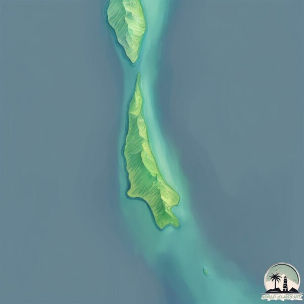
Geography and size of Pulau Buaya
Size: 0.548 km²
Coastline: 5 km
Ocean: Pacific Ocean
Sea: Gulf of Boni
Continent: Asia
Pulau Buaya is a Tiny Island spanning 0.548 km² with a coastline of 5 km.
Archipel: Greater Sunda Islands – A group of large islands in Southeast Asia, including Borneo, Sumatra, Java, and Sulawesi, known for their rich biodiversity and cultural diversity.
Tectonic Plate: Banda Sea – A small plate in the eastern Indonesian region, known for complex interactions with the Australian and Pacific plates, leading to notable seismic and volcanic activity.
The geographic heart of the island is pinpointed at these coordinates:
Latitude: -4.17090036 / Longitude: 121.48586213
Climate and weather of Pulau Buaya
Climate Zone: Tropical
Climate Details: Tropical Rainforest Climate
Temperature: Hot
Climate Characteristics: This climate is typified by heavy rainfall throughout the year, high humidity, and consistently high temperatures, leading to lush rainforests and rich biodiversity. Seasonal temperature variations are minimal.
Topography and nature of Pulau Buaya
Timezone: UTC+08:00
Timezone places: Australia/Perth
Max. Elevation: -2 m
Mean Elevation: -3 m
Vegetation: Evergreen Needleleaf Forest
Tree Coverage: 0%
The mean elevation is -3 m. Remarkably, this unique island barely emerges above the sea level, showcasing nature’s fascinating interplay with the ocean. The island is characterized by Plains: Flat, low-lying lands characterized by a maximum elevation of up to 200 meters. On islands, plains are typically coastal lowlands or central flat areas.
Dominating Vegetation: Evergreen Needleleaf Forest
Dominated by evergreen coniferous trees such as pines and firs, which retain their needle-like leaves throughout the year. These forests are often found in cooler climates. Pulau Buaya has a tree cover of 0 %.
Vegetation: 1 vegetation zones – Minimal Diversity Island
These islands exhibit the most basic level of ecological diversity, often characterized by a single dominant vegetation type. This could be due to extreme environmental conditions, limited land area, or significant human impact. They represent unique ecosystems where specific species have adapted to thrive in these singular environments.
Infrastructure and Travelling to Pulau Buaya
Does the island have a public airport? no.
There is no public and scheduled airport on Pulau Buaya. The nearest airport is Sangia Nibandera Airport, located 18 km away.
Does the island have a major port? no.
There are no major ports on Pulau Buaya. The closest major port is POMALAA, approximately 12 km away.
The mean population of Pulau Buaya is 66 per km². Pulau Buaya is Gently Populated. The island belongs to Indonesia.
Continuing your journey, Pulau Padamarang is the next notable island, situated merely km away.
Pulau Buaya Kalabahi Alor NTT


Indonesia is classified as Emerging region: MIKT: Mexico, Indonesia, South Korea, and Turkey – Economies recognized for their development potential and emerging market status. The level of income is Lower middle income.
News – Latest Updates and Headlines from Pulau Buaya
Stay informed with the most recent news and important headlines from Pulau Buaya. Here’s a roundup of the latest developments.
Please note: The data used here has been primarily extracted from satellite readings. Deviations from exact values may occur, particularly regarding the height of elevations and population density. Land area and coastline measurements refer to average values at mean high tide.