Welcome to Pulau Jawa, a Tropical island in the Makassar Strait, part of the majestic Pacific Ocean. This guide offers a comprehensive overview of what makes Pulau Jawa unique – from its geography and climate to its population, infrastructure, and beyond. Dive into the details:
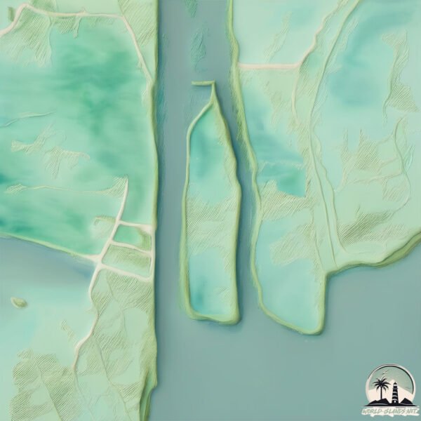
Geography and size of Pulau Jawa
Size: 3.021 km²
Coastline: 9.8 km
Ocean: Pacific Ocean
Sea: Makassar Strait
Continent: Asia
Pulau Jawa is a Small Island spanning 3 km² with a coastline of 9.8 km.
Archipel: Greater Sunda Islands – A group of large islands in Southeast Asia, including Borneo, Sumatra, Java, and Sulawesi, known for their rich biodiversity and cultural diversity.
Tectonic Plate: Birds Head – Also known as the Bird’s Head Plate, it is a small tectonic plate in the vicinity of the Bird’s Head Peninsula in West Papua. The plate is noted for its interactions with the Pacific, Australian, and Philippine Sea plates, contributing to the geological complexity of the region.
The geographic heart of the island is pinpointed at these coordinates:
Latitude: -0.86951065 / Longitude: 117.25912769
Climate and weather of Pulau Jawa
Climate Zone: Tropical
Climate Details: Tropical Rainforest Climate
Temperature: Hot
Climate Characteristics: This climate is typified by heavy rainfall throughout the year, high humidity, and consistently high temperatures, leading to lush rainforests and rich biodiversity. Seasonal temperature variations are minimal.
Topography and nature of Pulau Jawa
Timezone: UTC+08:00
Timezone places: Australia/Perth
Max. Elevation: 5 m
Mean Elevation: 4 m
Vegetation: Mangrove Forest
Tree Coverage: 53%
The mean elevation is 4 m. The highest elevation on the island reaches approximately 5 meters above sea level. The island is characterized by Plains: Flat, low-lying lands characterized by a maximum elevation of up to 200 meters. On islands, plains are typically coastal lowlands or central flat areas.
Dominating Vegetation: Mangrove Forest
Found in coastal areas and river deltas, these unique wetland ecosystems are adapted to saline conditions and are crucial for coastal protection and biodiversity. Pulau Jawa has a tree cover of 53 %.
Vegetation: 3 vegetation zones – Moderately Diverse Island
These islands start to show a broader range of ecological niches. With three vegetation zones, they may offer a mix of ecosystems like coastal areas, inland woods, and perhaps a distinct wetland or dry area. This diversity supports a wider range of flora and fauna, making these islands more ecologically complex than those with minimal diversity.
Infrastructure and Travelling to Pulau Jawa
Does the island have a public airport? no.
There is no public and scheduled airport on Pulau Jawa. The nearest airport is Aji Pangeran Tumenggung Pranoto International Airport, located 53 km away.
Does the island have a major port? no.
There are no major ports on Pulau Jawa. The closest major port is SENIPAH OIL TERMINAL, approximately 12 km away.
The mean population of Pulau Jawa is 35 per km². Pulau Jawa is Gently Populated. The island belongs to Indonesia.
The name of the island resonates across different cultures and languages. Here is how it is known around the world: Arabic: بورنيو; German: Borneo; Spanish: Isla de Borneo; French: Bornéo; Portuguese: Bornéu; Russian: Калимантан; Chinese: 婆罗洲
Continuing your journey, Pulau Bukuan is the next notable island, situated merely km away.
My Top 10 Places to Visit in Java, Indonesia (Travel Guide)
After 2 months of traveling through Indonesia I show you my 10 best places to visit in Java. ➸ My Indo Travel Planning Kit: ...My Top 10 Places to Visit in Java, Indonesia (Travel Guide)
After 2 months of traveling through Indonesia I show you my 10 best ...
After 2 months of traveling through Indonesia I show you my 10 best places to visit in Java. ➸ My Indo Travel Planning Kit: ...
Indonesia 4K Drone - Java, Sulawesi, & Sumatra - Islands, Volcanoes, & Waterfalls
Kenapa disebut Pulau Jawa? #shorts
Kenapa disebut Pulau Jawa? Pulau Jawa berasal dari bahasa Sansekerta ...
Kenapa disebut Pulau Jawa? Pulau Jawa berasal dari bahasa Sansekerta yang artinya ''Pulau Padi''. Istilah ini disebut di dalam ...
Kenapa Pulau Jawa Penduduknya Banyak Banget?
Pulau yang penuh-sesak itu bernama… Pulau Jawa! Satu pulau ini jadi ...
Pulau yang penuh-sesak itu bernama… Pulau Jawa! Satu pulau ini jadi rumah buat ratusan juta orang — ada jauh lebih banyak ...
Pulau Jawa Akan Tenggelam?
Pulau Jawa Akan Tenggelam? @mkmthings #jawa #pulaujawa #indonesia ...
Pulau Jawa Akan Tenggelam? @mkmthings #jawa #pulaujawa #indonesia #geografi #geografiindonesia #fenomena ...
Seberapa Gendengnya Pulau Jawa? Luasnya Setara Negara Bangladesh 🗿 #geography #geografi
Gendengnya Pulau Jawa: Luasnya Hanya 126 Kali Lebih Kecil dari Negara ...
Gendengnya Pulau Jawa: Luasnya Hanya 126 Kali Lebih Kecil dari Negara Terbesar di Dunia, Tapi Bisa Menampung Lebih dari ...
SURGA DIBALIK PULAU TERPADAT DI DUNIA | PULAU JAWA
Dalam video ini, adalah sebagian kecil dari keindahan pulau jawa. ...
Dalam video ini, adalah sebagian kecil dari keindahan pulau jawa. Namun setiap tempat ini, merupakan simbol keindahan, dan ...
Pulau Jawa, Sebelum Dihuni Manusia
YtCrash - Sumber ilmu pengetahuan yang tak akan pernah habis digali ...
YtCrash - Sumber ilmu pengetahuan yang tak akan pernah habis digali dan diolah menjadi bahan pelajaran berharga, untuk ...
KOK GAK ADA..?? Kemana Pulau Jawa Ketika Itu?
YtCrash - Gunung Lawu yang merupakan gunung tertua di Pulau Jawa ...
YtCrash - Gunung Lawu yang merupakan gunung tertua di Pulau Jawa dulunya diyakini berada di bawah laut. Hal itu lantaran ...
38 Indonesian Street Foods in Java Island - SURABAYA #1 Duck + SEMARANG Nasi Goreng + SOLO Best Sate
indonesianfood #java #halal #surabaya #semarang #solo SUBSCRIBE: ...
Kenapa Pulau Jawa Padat Banget? Ini Jawabannya!
Tahukah kamu… kenapa 56% penduduk Indonesia tinggal di Pulau Jawa? ...
Tahukah kamu… kenapa 56% penduduk Indonesia tinggal di Pulau Jawa? Padahal, secara ukuran, Jawa itu cuma sekitar 7% ...
Most Beautiful Places in Indonesia ✈️ 🌍 😱
Most Beautiful Places in Indonesia The Mentawai Islands - Paradise ...
Most Beautiful Places in Indonesia The Mentawai Islands - Paradise Lake Banggai Islands - Bali #shorts #nature #travel #explore ...
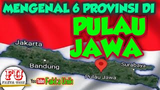
Daftar Provinsi di Pulau Jawa
Daftar Provinsi di Pulau Jawa. Provinsi Jawa barat terletak di pulau ...
Daftar Provinsi di Pulau Jawa. Provinsi Jawa barat terletak di pulau Jawa bagian barat, provinsi Jawa timur terletak di bagian ...
Pulau Bawean: Pulau Para Perantau di tengah Laut Jawa #PulauBawean #Boyan #WisataJawaTimur #Rantau
Pulau Bawean: Pulau Perantau di Laut Jawa Timur Inilah Pulau Bawean, ...
Pulau Bawean: Pulau Perantau di Laut Jawa Timur Inilah Pulau Bawean, pulau kecil yang terletak di Laut Jawa dan masuk ...
Pulau JAWA lebih besar dari yang anda pikirkan
Pulau Jawa lebih besar dari yang Anda pikirkan, dalam hal ukuran, ...
Pulau Jawa lebih besar dari yang Anda pikirkan, dalam hal ukuran, pulau jawa lebih besar dari Korea Utara dan korea Selatan, ...
Peta Pulau Jawa, Republik Indonesia.
Peta Pulau Jawa Indonesia. Pulau Jawa adalah pulau terluas ke 13 di ...
Peta Pulau Jawa Indonesia. Pulau Jawa adalah pulau terluas ke 13 di Dunia. Dengan luas wilayahnya 132.114 Km2 Pulau Jawa ...
Pulau Jawa: Alam Tua yang Masih Bernapas, Tempat Flora Fauna Langka
Di balik hiruk-pikuk kota dan padatnya kehidupan manusia, Pulau Jawa ...
Di balik hiruk-pikuk kota dan padatnya kehidupan manusia, Pulau Jawa menyimpan dunia tua yang masih bernapas.
Karimun Jawa | Pulau Cantik di Pulau Jawa
DESA INI BERADA DIATAS AWAN | INILAH DESA TERTINGGI DI PULAU JAWA 2326 MDPL
DESA ARGOSARI SENDURO LUMAJANG MENJADI DESA TERTINGGI DI PULAU JAWA ...
DESA ARGOSARI SENDURO LUMAJANG MENJADI DESA TERTINGGI DI PULAU JAWA DENGAN KETINGGIAN 2326 MDPL.
Kondisi Geografis Pulau Jawa Sebagai Pulau Terpadat Di Dunia
Video Lainnya: Melihat Pulau Papua Dari Letak Geografisnya ...
Ini Dia Alasan Mengapa Pulau Jawa Dan Pulau Bali Tidak Di Bangun Jembatan! #subscribe #geography
Jika di lihat dari peta, jarak antara Pulau Jawa dan Pulau Bali hanya ...
Jika di lihat dari peta, jarak antara Pulau Jawa dan Pulau Bali hanya 5 km saja. Lantas kenapa pemerintah tidak membangun ...
Pulau Terluar di Selatan Jawa Timur
Terbang dari Jakarta ke Nusa Barong.
Terbang dari Jakarta ke Nusa Barong.
KEINDAHAN PULAU KARIMUN JAWA ISLAND #karimunjawa #karimunjawaisland #shortviral #shorts #jepara
Keindahan pulau karimun jawa jepara banyak ikan di pinggir pelabuhan ...
Keindahan pulau karimun jawa jepara banyak ikan di pinggir pelabuhan karimun jawa #shortviral #shortsvideo #ikan ...
Kepulauan Karimunjawa Lebih dari Sekadar Pesona Pantainya #faktaunik #sejarah
Dalam video ini, kita akan membuka tabir keindahan dan misteri yang ...
Dalam video ini, kita akan membuka tabir keindahan dan misteri yang tersembunyi di balik nama yang mungkin sudah familiar, ...
Rumah Asli Sang Black Panther | Pulau Jawa – Part 1
Di antara lebih dari 17.000 pulau yang tersebar di seluruh Indonesia, ...
Di antara lebih dari 17.000 pulau yang tersebar di seluruh Indonesia, ada satu pulau yang paling padat oleh manusia. Dari total ...
Indonesia is classified as Emerging region: MIKT: Mexico, Indonesia, South Korea, and Turkey – Economies recognized for their development potential and emerging market status. The level of income is Lower middle income.
News – Latest Updates and Headlines from Pulau Jawa
Stay informed with the most recent news and important headlines from Pulau Jawa. Here’s a roundup of the latest developments.
Loading...
Please note: The data used here has been primarily extracted from satellite readings. Deviations from exact values may occur, particularly regarding the height of elevations and population density. Land area and coastline measurements refer to average values at mean high tide.