Pulau Jinatung
Welcome to Pulau Jinatung, a Tropical island in the Banda Sea, part of the majestic Pacific Ocean. This guide offers a comprehensive overview of what makes Pulau Jinatung unique – from its geography and climate to its population, infrastructure, and beyond. Dive into the details:
- Geography and Size: Explore the island’s size and location.
- Climate and Weather: Weather patterns and temperature.
- Topography and Nature: Uncover the natural wonders of the island.
- Infrastructure and Travelling: Insights on reaching, staying, and making the most of your visit.
- News and Headlines: Latest News.
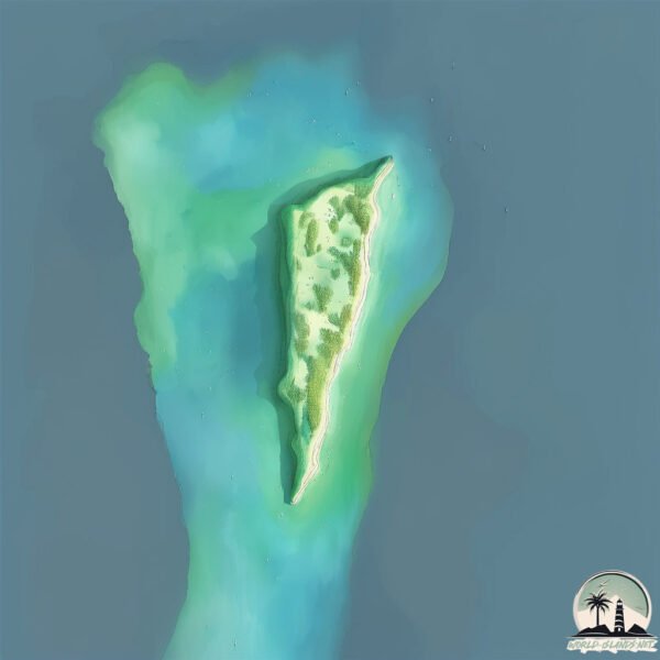
Geography and size of Pulau Jinatung
Size: 0.629 km²
Coastline: 4.9 km
Ocean: Pacific Ocean
Sea: Banda Sea
Continent: Asia
Pulau Jinatung is a Tiny Island spanning 0.629 km² with a coastline of 4.9 km.
Archipel: Malay Archipelago – The world’s largest archipelago, located between mainland Southeast Asia and Australia, known for its immense biodiversity and cultural diversity.
Tectonic Plate: Banda Sea – A small plate in the eastern Indonesian region, known for complex interactions with the Australian and Pacific plates, leading to notable seismic and volcanic activity.
The geographic heart of the island is pinpointed at these coordinates:
Latitude: -6.75649971 / Longitude: 120.96843898
Climate and weather of Pulau Jinatung
Climate Zone: Tropical
Climate Details: Tropical Savanna, Wet
Temperature: Hot
Climate Characteristics: Defined by distinct wet and dry seasons with high temperatures year-round. Pronounced rainfall occurs during the wet season, while the dry season is marked by drought.
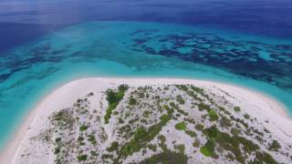
Topography and nature of Pulau Jinatung
Timezone: UTC+08:00
Timezone places: Australia/Perth
Max. Elevation: 2 m
Mean Elevation: 1 m
Vegetation: Open Woodland
Tree Coverage: 40%
The mean elevation is 1 m. The highest elevation on the island reaches approximately 2 meters above sea level. The island is characterized by Plains: Flat, low-lying lands characterized by a maximum elevation of up to 200 meters. On islands, plains are typically coastal lowlands or central flat areas.
Dominating Vegetation: Open Woodland
Characterized by sparsely distributed trees with open canopy allowing sunlight to penetrate, supporting grasses and shrubs underneath. Often found in drier or transitional environments. Pulau Jinatung has a tree cover of 40 %.
Vegetation: 2 vegetation zones – Low Diversity Island
Islands with two distinct vegetation zones offer slightly more ecological variety. These zones could be due to differences in elevation, moisture, or other environmental factors. While still limited in biodiversity, these islands may offer a contrast between the two zones, such as a coastline with mangroves and an inland area with grassland.
Infrastructure and Travelling to Pulau Jinatung
Does the island have a public airport? no.
There is no public and scheduled airport on Pulau Jinatung. The nearest airport is Selayar – Haji Aroeppala Airport, located 87 km away.
Does the island have a major port? no.
There are no major ports on Pulau Jinatung. The closest major port is BAUBAU, approximately 232 km away.
The mean population of Pulau Jinatung is 122 per km². Pulau Jinatung is Moderately Inhabited. The island belongs to Indonesia.
Continuing your journey, Pulau Kayuadi is the next notable island, situated merely km away.
TRIP Pulau JINATO Ke Pulau BONERATE ‼️Menikmati Sunset dijalan.


Indonesia is classified as Emerging region: MIKT: Mexico, Indonesia, South Korea, and Turkey – Economies recognized for their development potential and emerging market status. The level of income is Lower middle income.
News – Latest Updates and Headlines from Pulau Jinatung
Stay informed with the most recent news and important headlines from Pulau Jinatung. Here’s a roundup of the latest developments.
Please note: The data used here has been primarily extracted from satellite readings. Deviations from exact values may occur, particularly regarding the height of elevations and population density. Land area and coastline measurements refer to average values at mean high tide.