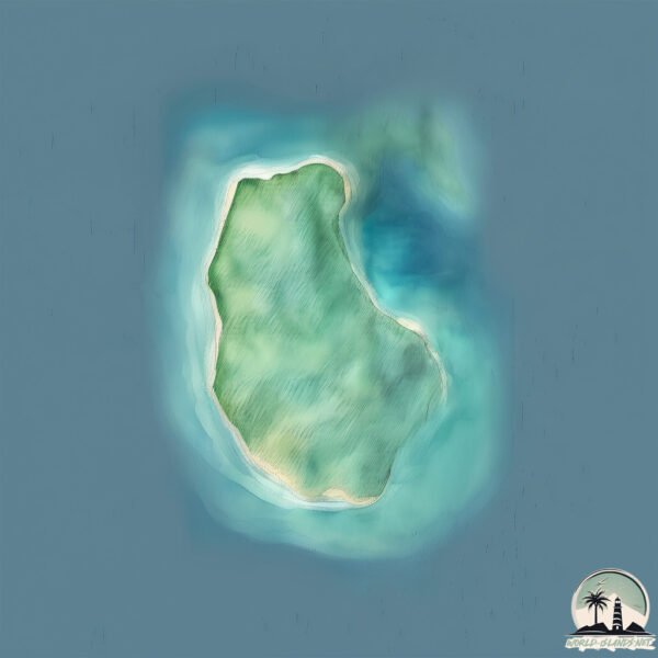
Welcome to Pulau Karangmajat, a Tropical island in the Indian Ocean, part of the majestic Indian Ocean. This guide offers a comprehensive overview of what makes Pulau Karangmajat unique – from its geography and climate to its population, infrastructure, and beyond. Dive into the details:
Geography and size of Pulau Karangmajat
Size: 4.655 km²
Coastline: 16.8 km
Ocean: Indian Ocean
Sea: Indian Ocean
Continent: Asia
Pulau Karangmajat is a Small Island spanning 4.7 km² with a coastline of 16.8 km.
Archipel: Malay Archipelago – The world’s largest archipelago, located between mainland Southeast Asia and Australia, known for its immense biodiversity and cultural diversity.
Tectonic Plate: Sunda – Extends across Southeast Asia, encompassing parts of the Sunda Shelf, known for its interaction with the Australian Plate, contributing to volcanic activity in Indonesia.
The geographic heart of the island is pinpointed at these coordinates:
Latitude: -1.91415179 / Longitude: 99.30127673
Climate and weather of Pulau Karangmajat
Climate Zone: Tropical
Climate Details: Tropical Rainforest Climate
Temperature: Hot
Climate Characteristics: This climate is typified by heavy rainfall throughout the year, high humidity, and consistently high temperatures, leading to lush rainforests and rich biodiversity. Seasonal temperature variations are minimal.
Topography and nature of Pulau Karangmajat
Timezone: UTC+07:00
Timezone places: Asia/Jakarta
Max. Elevation: -1 m
Mean Elevation: -4 m
Vegetation: Evergreen Broadleaf Forest
Tree Coverage: 43%
The mean elevation is -4 m. Remarkably, this unique island barely emerges above the sea level, showcasing nature’s fascinating interplay with the ocean. The island is characterized by Plains: Flat, low-lying lands characterized by a maximum elevation of up to 200 meters. On islands, plains are typically coastal lowlands or central flat areas.
Dominating Vegetation: Evergreen Broadleaf Forest
Characterized by dense, lush canopies of broadleaf trees that retain their leaves year-round. These forests are typically found in tropical and subtropical regions and are known for their high biodiversity. Pulau Karangmajat has a tree cover of 43 %.
Vegetation: 8 vegetation zones – Very Highly Diverse Island
Islands in this range are ecological powerhouses, showcasing a wide array of vegetation zones. Each zone, from lush rainforests to arid scrublands, coastal mangroves to mountainous regions, contributes to a complex and interdependent ecosystem. These islands are often hotspots of biodiversity, supporting numerous species and intricate ecological processes.
Infrastructure and Travelling to Pulau Karangmajat
Does the island have a public airport? no.
There is no public and scheduled airport on Pulau Karangmajat. The nearest airport is Tabing Airport, located 163 km away.
Does the island have a major port? no.
There are no major ports on Pulau Karangmajat. The closest major port is TELUK BAYUR, approximately 155 km away.
The mean population of Pulau Karangmajat is per km². Pulau Karangmajat is . The island belongs to Indonesia.
Continuing your journey, Pulau Masokut is the next notable island, situated merely km away.
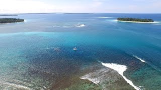
Kandui Island - Mentawais - Indonesia
This video is from a recent trip to Kandui Villas. On a small island in the Mentawai Island Chain, off of Sumatra. Shot with the DJI ...Kandui Island - Mentawais - Indonesia
This video is from a recent trip to Kandui Villas. On a small island ...
This video is from a recent trip to Kandui Villas. On a small island in the Mentawai Island Chain, off of Sumatra. Shot with the DJI ...
Kandui Villas Mentawai Island #mentawai #surfing #mentawaiislands #mentawaisurf #surfingphotography
Info netizen. Kapal terdampar Lokasi di Pulau Karangmajat Siberut barat daya Mentawai
Dokumenter Pos Pengawas Pantai Karamajat 2017
About Mentawai surfing tax.
About Mentawai surfing tax.
Heboh Pulau Pananggalat Dijual,
MetroTV, Pulau Pananggalat di Mentawai, Sumatra Barat, sempat dijual ...
MetroTV, Pulau Pananggalat di Mentawai, Sumatra Barat, sempat dijual situs properti asing seharga Rp15,57 miliar. Hal tersebut ...
Tepian Negeri itu Bernama Pulau Pagai, Kepulauan Mentawai
Global Zakat, Aksi Cepat Tanggap (ACT) tiba di Desa Sikakap, desa yang ...
Global Zakat, Aksi Cepat Tanggap (ACT) tiba di Desa Sikakap, desa yang menjadi pusat keramaian dari Kecamatan Sikakap, ...
Ini Penjelasan Dinas Kelautan dan Perikanan Terkait Penjualan Pulau Pananggalat
Kepala Dinas Kelautan dan Perikanan Sumatera Barat menegaskan isu ...
Kepala Dinas Kelautan dan Perikanan Sumatera Barat menegaskan isu terkait penjualan pulau panangalat di Kabupaten ...
Kandui Resort Part 1 - Family Surf Trip to the Mentawai Islands. Kids learning to surf in Indonesia
Our first full family surf trip overseas! We head to Kandui Resort and ...
Our first full family surf trip overseas! We head to Kandui Resort and find amazing waves, sea snakes, snorkelling, speedy hermit ...
WELCOME TO KANDUI RESORT
A detailed look into a trip to Kandui Resort. There's no place in the ...
A detailed look into a trip to Kandui Resort. There's no place in the surfing world like the Mentawais and there's no place in the ...
Explore Surf camp Sumatera~Kandui Resort and Kandui Villas
kandui_resort #kandui_villas Kandui memang menawarkan pengalaman ...
kandui_resort #kandui_villas Kandui memang menawarkan pengalaman maksimal untuk menikmati ombak di Mentawai.
mentawai kandui villas
salah satu resort yang terletak di kepulauan mentawai, pulau karang ...
salah satu resort yang terletak di kepulauan mentawai, pulau karang majat siberut batar daya.. bernama kandui villas..
Trip to Kandui Villas Island in Mentawai
Halo guys…. Kembali lagi sama aku, aku mahasiswa penerima beasiswa KIP ...
Halo guys…. Kembali lagi sama aku, aku mahasiswa penerima beasiswa KIP tahun 2022/2023 di Institut Pariwisata Trisakti ...
WAW PUSKESMAS MEWAH DI PULAU TERPENCIL
ASSALAMUALAIKUM PUSKESMAS PEI PEI PASAKIAT TAILELU BERADA DI DESA ...
ASSALAMUALAIKUM PUSKESMAS PEI PEI PASAKIAT TAILELU BERADA DI DESA TAILELEU TEPAT NYA DI KECAMATAN ...
Kandui Villas® Kandui® Virtual Tour Video
Kandui Villas®, the world's premier luxury surfing destination, ...
Kandui Villas®, the world's premier luxury surfing destination, features deluxe accommodations, infinity pool, and gourmet meals, ...
Detik-detik senja di pulau MENTAWAI
Beautyfull sky,indahnya detik"senja dilaut Mentawai #pagai ...
Beautyfull sky,indahnya detik"senja dilaut Mentawai #pagai #karangmajat #siberut #sipora #tuapejat #tiop.
Tinjau pulau Pananggalat yang diisukan di jual lewat situs Online Asing
Kandui Villas | Luxury Mentawai Premier Waves
Indulge in the surf getaway of your dreams when you visit Kandui ...
Indulge in the surf getaway of your dreams when you visit Kandui Villas, a stunning combination of world-class luxury ...
Pulau Panaggalat Kep. Mentawai Muncul Disitus Penjualan Online
Pemkab Mentawai Membantah Isu Penjualan Salah Satu Pulau Di ...
Pemkab Mentawai Membantah Isu Penjualan Salah Satu Pulau Di Wilayahnya. Pihaknya Menyebut Secara Aturan Sudah ...
Pei-Pei, Siberut Barat Daya, Mentawai dilihat dari DRONE
Heboh Pulau Pananggalat Dijual, Kemenko Marves Menjelaskan Itu Tidak Benar
Heboh Pulau Pananggalat Dijual, Kemenko Marves Menjelaskan Itu Tidak ...
Heboh Pulau Pananggalat Dijual, Kemenko Marves Menjelaskan Itu Tidak Benar #PulauPananggalat #mediaindonesia ...
Shoulder Season in the Mentawais at Kandui Resort (Bankvaults, Burgerworld & NIpussi)
mentawaiisland #kandui #surfingindonesia The Mentawai islands are a ...
mentawaiisland #kandui #surfingindonesia The Mentawai islands are a small chain of islands off the west coast of Sumatra, ...
Indahnya Pulau Mentawai Siberut Barat Daya
Wisata Mentawai Kandui Resort#BeasiswaKIPkuliah#IPTtrisakti
Saya Handrianus samaloisa Mahasiswa penerima Beasiswa KIP ...
Saya Handrianus samaloisa Mahasiswa penerima Beasiswa KIP #beasiswasKIP #IPTtrisakti Jurusan S1 Pariwisata Trisakti ...
Lagi! Pulau Milik Indonesia Dijual Untuk Kepentingan Asing
Lagi! Pulau di NKRI dijual kepada pihak asing. Kali ini Pulau ...
Lagi! Pulau di NKRI dijual kepada pihak asing. Kali ini Pulau Panangalat yang berada di Mentawai Utara dijual di salah satu situs ...
MENTAWAI SURF SUMMER HOLIDAY KANDUI VILLAS
Welcome to the Kandui Villas® YouTube channel! Experience the ultimate ...
Welcome to the Kandui Villas® YouTube channel! Experience the ultimate luxury surf resort in the stunning Mentawai Islands, ...
Indonesia is classified as Emerging region: MIKT: Mexico, Indonesia, South Korea, and Turkey – Economies recognized for their development potential and emerging market status. The level of income is Lower middle income.
News – Latest Updates and Headlines from Pulau Karangmajat
Stay informed with the most recent news and important headlines from Pulau Karangmajat. Here’s a roundup of the latest developments.
Loading...
Please note: The data used here has been primarily extracted from satellite readings. Deviations from exact values may occur, particularly regarding the height of elevations and population density. Land area and coastline measurements refer to average values at mean high tide.