Pulau Kluang
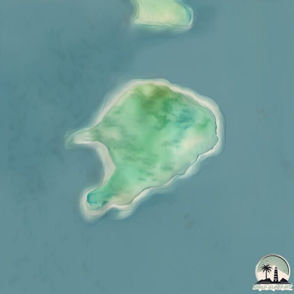
Welcome to Pulau Kluang, a Tropical island in the Indian Ocean, part of the majestic Indian Ocean. This guide offers a comprehensive overview of what makes Pulau Kluang unique – from its geography and climate to its population, infrastructure, and beyond. Dive into the details:
- Geography and Size: Explore the island’s size and location.
- Climate and Weather: Weather patterns and temperature.
- Topography and Nature: Uncover the natural wonders of the island.
- Infrastructure and Travelling: Insights on reaching, staying, and making the most of your visit.
- News and Headlines: Latest News.
Geography and size of Pulau Kluang
Size: 1.445 km²
Coastline: 5.3 km
Ocean: Indian Ocean
Sea: Indian Ocean
Continent: Asia
Pulau Kluang is a Small Island spanning 1.4 km² with a coastline of 5.3 km.
Archipel: Greater Sunda Islands – A group of large islands in Southeast Asia, including Borneo, Sumatra, Java, and Sulawesi, known for their rich biodiversity and cultural diversity.
Tectonic Plate: Sunda – Extends across Southeast Asia, encompassing parts of the Sunda Shelf, known for its interaction with the Australian Plate, contributing to volcanic activity in Indonesia.
The geographic heart of the island is pinpointed at these coordinates:
Latitude: 5.1151186 / Longitude: 95.28955924
Climate and weather of Pulau Kluang
Climate Zone: Tropical
Climate Details: Tropical Rainforest Climate
Temperature: Hot
Climate Characteristics: This climate is typified by heavy rainfall throughout the year, high humidity, and consistently high temperatures, leading to lush rainforests and rich biodiversity. Seasonal temperature variations are minimal.
Topography and nature of Pulau Kluang
Timezone: UTC+07:00
Timezone places: Asia/Jakarta
Max. Elevation: 4 m
Mean Elevation: -14 m
Vegetation: Evergreen Broadleaf Forest
Tree Coverage: 59%
The mean elevation is -14 m. The highest elevation on the island reaches approximately 4 meters above sea level. The island is characterized by Plains: Flat, low-lying lands characterized by a maximum elevation of up to 200 meters. On islands, plains are typically coastal lowlands or central flat areas.
Dominating Vegetation: Evergreen Broadleaf Forest
Characterized by dense, lush canopies of broadleaf trees that retain their leaves year-round. These forests are typically found in tropical and subtropical regions and are known for their high biodiversity. Pulau Kluang has a tree cover of 59 %.
Vegetation: 4 vegetation zones – Diverse Island
Four distinct vegetation zones mark these islands as ecologically diverse. They might feature varied landscapes such as forests, beaches, grasslands, and rocky areas. Such diversity reflects the island’s complex ecological interactions and varied habitats, which can support a rich array of wildlife and plant species.
Infrastructure and Travelling to Pulau Kluang
Does the island have a public airport? no.
There is no public and scheduled airport on Pulau Kluang. The nearest airport is Sultan Iskandar Muda International Airport, located 47 km away.
Does the island have a major port? no.
There are no major ports on Pulau Kluang. The closest major port is ULEELHEUE, approximately 50 km away.
The mean population of Pulau Kluang is 19 per km². Pulau Kluang is Gently Populated. The island belongs to Indonesia.
Continuing your journey, Pulau Peunasu is the next notable island, situated merely km away.
Kluang ISLAND


Indonesia is classified as Emerging region: MIKT: Mexico, Indonesia, South Korea, and Turkey – Economies recognized for their development potential and emerging market status. The level of income is Lower middle income.
News – Latest Updates and Headlines from Pulau Kluang
Stay informed with the most recent news and important headlines from Pulau Kluang. Here’s a roundup of the latest developments.
Please note: The data used here has been primarily extracted from satellite readings. Deviations from exact values may occur, particularly regarding the height of elevations and population density. Land area and coastline measurements refer to average values at mean high tide.