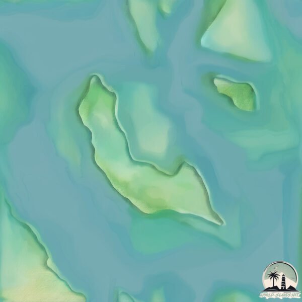
Welcome to Pulau Lemas, a Tropical island in the South China Sea, part of the majestic Pacific Ocean. This guide offers a comprehensive overview of what makes Pulau Lemas unique – from its geography and climate to its population, infrastructure, and beyond. Dive into the details:
Geography and size of Pulau Lemas
Size: 0.591 km²
Coastline: 4.6 km
Ocean: Pacific Ocean
Sea: South China Sea
Continent: Asia
Pulau Lemas is a Tiny Island spanning 0.591 km² with a coastline of 4.6 km.
Archipel: Greater Sunda Islands – A group of large islands in Southeast Asia, including Borneo, Sumatra, Java, and Sulawesi, known for their rich biodiversity and cultural diversity.
Tectonic Plate: Sunda – Extends across Southeast Asia, encompassing parts of the Sunda Shelf, known for its interaction with the Australian Plate, contributing to volcanic activity in Indonesia.
The geographic heart of the island is pinpointed at these coordinates:
Latitude: 0.87246904 / Longitude: 103.79647584
Climate and weather of Pulau Lemas
Climate Zone: Tropical
Climate Details: Tropical Rainforest Climate
Temperature: Hot
Climate Characteristics: This climate is typified by heavy rainfall throughout the year, high humidity, and consistently high temperatures, leading to lush rainforests and rich biodiversity. Seasonal temperature variations are minimal.
Topography and nature of Pulau Lemas
Timezone: UTC+07:00
Timezone places: Asia/Jakarta
Max. Elevation: 6 m
Mean Elevation: 4 m
Vegetation: Evergreen Broadleaf Forest
Tree Coverage: 31%
The mean elevation is 4 m. The highest elevation on the island reaches approximately 6 meters above sea level. The island is characterized by Plains: Flat, low-lying lands characterized by a maximum elevation of up to 200 meters. On islands, plains are typically coastal lowlands or central flat areas.
Dominating Vegetation: Evergreen Broadleaf Forest
Characterized by dense, lush canopies of broadleaf trees that retain their leaves year-round. These forests are typically found in tropical and subtropical regions and are known for their high biodiversity. Pulau Lemas has a tree cover of 31 %.
Vegetation: 1 vegetation zones – Minimal Diversity Island
These islands exhibit the most basic level of ecological diversity, often characterized by a single dominant vegetation type. This could be due to extreme environmental conditions, limited land area, or significant human impact. They represent unique ecosystems where specific species have adapted to thrive in these singular environments.
Infrastructure and Travelling to Pulau Lemas
Does the island have a public airport? no.
There is no public and scheduled airport on Pulau Lemas. The nearest airport is Hang Nadim International Airport, located 45 km away.
Does the island have a major port? no.
There are no major ports on Pulau Lemas. The closest major port is SEKUPANG, approximately 31 km away.
The mean population of Pulau Lemas is 278 per km². Pulau Lemas is Moderately Inhabited. The island belongs to Indonesia.
Continuing your journey, Pulau Sugi is the next notable island, situated merely km away.
Never Visit This Island…
Would you visit the North Sentinel Island? All credit goes to the original creator: @nelkfilmz Join this channel to get access to ...Never Visit This Island…
Would you visit the North Sentinel Island? All credit goes to the ...
Would you visit the North Sentinel Island? All credit goes to the original creator: @nelkfilmz Join this channel to get access to ...
The island of Queimada Grande, where the only living thing is hundreds of thousands of snakes,
The island of Queimada Grande, where the only living thing is hundreds ...
The island of Queimada Grande, where the only living thing is hundreds of thousands of snakes,
Found Moana Island on Google Earth! #googleearth #shorts
Impossible Feat: Surviving on North Sentinel Island
Will he survive? #impossiblefeats #ai #aishorts.
Will he survive? #impossiblefeats #ai #aishorts.
Have you heard of this country before?! Welcome to PALAU 🇵🇼 We just arrived in this tiny island
Have you heard of this country before?! Welcome to PALAU We just ...
Have you heard of this country before?! Welcome to PALAU We just arrived in this tiny island nation in the western Pacific, ...
lemas di kg salang pulau tioman | snorkeling coral island
I Found Moana Island🏝 On Google Earth😱 #shorts #moana
I Found Moana Island On Google Earth #shorts #shortvideo #moana ...
I Found Moana Island On Google Earth #shorts #shortvideo #moana #googleearth #googlemaps #ytshorts #viral #viralshort ...
Rare Videotape of North Sentinel Island 🏝 #shorts
LEMAS | Remaja Hilang Dibawa Arus Di Pulau Giam
Seorang remaja lelaki dikhuatiri lemas ketika melakukan aktiviti laut ...
Seorang remaja lelaki dikhuatiri lemas ketika melakukan aktiviti laut di Pulau Giam berhampiran pantai Teluk Nipah, Pulau ...
TENTERA MAUT, SEORANG HILANG | Kes Babitkan Lemas, Punca Sebenar Masih Disiasat
Punca kejadian yang mengorbankan seorang anggota tentera manakala ...
Punca kejadian yang mengorbankan seorang anggota tentera manakala seorang lagi masih hilang ketika melaksanakan operasi ...
Snorkeling di Pulau Perhentian‼️ Adzreen hampir lemas! #travel #pulau #snorkeling #island
The Isle Of Man TT - Most Hardcore Extreme Sport In The World 🌎
Road racing empire Subscribe Consider joining our memberships to ...
Road racing empire Subscribe Consider joining our memberships to support us, support real road racing ...
$50,000 Cayman Islands
Learn more here: thenextgenbusiness.com #shorts #salary #taxes ...
Learn more here: thenextgenbusiness.com #shorts #salary #taxes #caymanislands #democrat #republican.
🌊 Ultimate Betrayal on a Deserted Island #shorts
Ultimate Betrayal on a Deserted Island #shorts.
Ultimate Betrayal on a Deserted Island #shorts.
Surviving the World's Most Deadliest Islands!
We regret going to these islands! special thanks to ...
We regret going to these islands! special thanks to @JayPrehistoricPetsTV for helping with snake island and special thanks to ...
EVERY CODE In Island Of Move!
In this short, I'm showing you ALL 6 CODES in Roblox's ISLAND OF MOVE! ...
In this short, I'm showing you ALL 6 CODES in Roblox's ISLAND OF MOVE! Enjoy! SUBSCRIBE & Turn On Notifications To Never ...
Why You Should NOT Travel to The Faroe Islands
Anggota tentera maut, seorang lagi hilang di Pulau Mataking
Menurut kenyataan itu, dua anggota tentera berkenaan sedang ...
Menurut kenyataan itu, dua anggota tentera berkenaan sedang melaksanakan Operasi Pasir Sektor Semporna Siri 3/2025 di ...
The Most Remote Uninhabited Island in the World 📍 Bouvet Island 🏝️#map #geography #explanation
Did you know where is the most remote uninhibited island in the world? ...
Did you know where is the most remote uninhibited island in the world? Where is Bouvet Island? Transcription: What if you want to ...
Pegawai 69 Komando maut ketika latihan menyelam di Pulau Mataking
Seorang pegawai kanan pasukan elit PDRM, Inspektor Khairul Azhar ...
Seorang pegawai kanan pasukan elit PDRM, Inspektor Khairul Azhar Kamaruddin dari 69 Komando, meninggal dunia ketika ...
Mati lemas Di pulau sibu
rettoshisha @rettohotel To PULAU SIBU.
rettoshisha @rettohotel To PULAU SIBU.
Beautiful Maldives in the 5* resort Como Cocoa Island 🤩🏝️ #maldives #luxurytravel #bestresorts
Como Cocoa Island is a 5* Luxury Resort in the Maldives with 30 ...
Como Cocoa Island is a 5* Luxury Resort in the Maldives with 30 overwater villas.
snake island in Brazil #sanakeislandbrazil #brazil #snakes #island #stone #sea #naturalvideo
snake island in Brazil #sanakeislandbrazil #brazil #snakes #island ...
snake island in Brazil #sanakeislandbrazil #brazil #snakes #island #stone #sea #naturalvideo my YouTube channel "Treasure of ...
Snake Island #brazil #south #america #earth #climatechange #snake #upsc #ias #animation #gigachad
Indonesia is classified as Emerging region: MIKT: Mexico, Indonesia, South Korea, and Turkey – Economies recognized for their development potential and emerging market status. The level of income is Lower middle income.
News – Latest Updates and Headlines from Pulau Lemas
Stay informed with the most recent news and important headlines from Pulau Lemas. Here’s a roundup of the latest developments.
Loading...
Please note: The data used here has been primarily extracted from satellite readings. Deviations from exact values may occur, particularly regarding the height of elevations and population density. Land area and coastline measurements refer to average values at mean high tide.