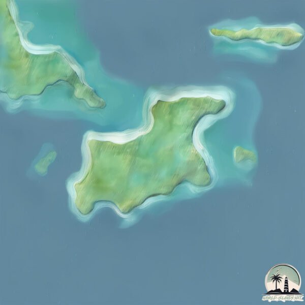
Welcome to Pulau Lintang, a Tropical island in the South China Sea, part of the majestic Pacific Ocean. This guide offers a comprehensive overview of what makes Pulau Lintang unique – from its geography and climate to its population, infrastructure, and beyond. Dive into the details:
Geography and size of Pulau Lintang
Size: 1.699 km²
Coastline: 7 km
Ocean: Pacific Ocean
Sea: South China Sea
Continent: Asia
Pulau Lintang is a Small Island spanning 1.7 km² with a coastline of 7 km.
Archipel: Malay Archipelago – The world’s largest archipelago, located between mainland Southeast Asia and Australia, known for its immense biodiversity and cultural diversity.
Tectonic Plate: Sunda – Extends across Southeast Asia, encompassing parts of the Sunda Shelf, known for its interaction with the Australian Plate, contributing to volcanic activity in Indonesia.
The geographic heart of the island is pinpointed at these coordinates:
Latitude: 2.71875486 / Longitude: 106.25968042
Climate and weather of Pulau Lintang
Climate Zone: Tropical
Climate Details: Tropical Rainforest Climate
Temperature: Hot
Climate Characteristics: This climate is typified by heavy rainfall throughout the year, high humidity, and consistently high temperatures, leading to lush rainforests and rich biodiversity. Seasonal temperature variations are minimal.
Topography and nature of Pulau Lintang
Timezone: UTC+07:00
Timezone places: Asia/Jakarta
Max. Elevation: 27 m
Mean Elevation: 24 m
Vegetation: Agricultural Mosaic
Tree Coverage: 91%
The mean elevation is 24 m. The highest elevation on the island reaches approximately 27 meters above sea level. The island is characterized by Plains: Flat, low-lying lands characterized by a maximum elevation of up to 200 meters. On islands, plains are typically coastal lowlands or central flat areas.
Dominating Vegetation: Agricultural Mosaic
A mix of cropland and natural vegetation, often seen in rural landscapes where agricultural fields are interspersed with patches of natural habitats. Pulau Lintang has a tree cover of 91 %.
Vegetation: 6 vegetation zones – Very Highly Diverse Island
Islands in this range are ecological powerhouses, showcasing a wide array of vegetation zones. Each zone, from lush rainforests to arid scrublands, coastal mangroves to mountainous regions, contributes to a complex and interdependent ecosystem. These islands are often hotspots of biodiversity, supporting numerous species and intricate ecological processes.
Infrastructure and Travelling to Pulau Lintang
Does the island have a public airport? no.
There is no public and scheduled airport on Pulau Lintang. The nearest airport is Tioman Airport, located 233 km away.
Does the island have a major port? no.
There are no major ports on Pulau Lintang. The closest major port is TAREMPAH, approximately 55 km away.
The mean population of Pulau Lintang is 33 per km². Pulau Lintang is Gently Populated. The island belongs to Indonesia.
Continuing your journey, Pulau Airabu is the next notable island, situated merely km away.
Inilah Titik Nol Dunia yang Tersembunyi di Tengah Laut!
Tahukah kamu, di mana pusat dunia berada? Sebagian orang percaya pusat dunia itu di Mekkah, Arab Saudi. Ada juga yang ...Inilah Titik Nol Dunia yang Tersembunyi di Tengah Laut!
Tahukah kamu, di mana pusat dunia berada? Sebagian orang percaya pusat ...
Tahukah kamu, di mana pusat dunia berada? Sebagian orang percaya pusat dunia itu di Mekkah, Arab Saudi. Ada juga yang ...
Pulau Bulang Lintang
di pulau ini ada makam pahlawan benderaha kerajaan lingga kalau ...
di pulau ini ada makam pahlawan benderaha kerajaan lingga kalau rajanya di makam kan di pulau penyengat tanjung pinang, ...
2018 Jun 22 : Kenangan Jalan Lintas Tengah Sumatera Pulau Lintang Bathin Sorolangun Jambi
Video lainnya klik link ini : ...
Eksplor Pulau Labun
Pulau labun, recomended bsnget.
Pulau labun, recomended bsnget.
Pulau Makalehi | Pulau Terluar di Sulawesi Utara
omzepro#outdooractivity#GIS#surveyandmapping.
omzepro#outdooractivity#GIS#surveyandmapping.
TERNYATA DI PULAU BULANG LINTANG MAKAM PAHLAWAN TEMENGGUNG ABDUL JAMAL
PULAU PALING BERBAHAYA DI DUNIA
Manado - pulau miangas, sulawesi utara🇲🇨#manado #traveling #pelayaran#reels #shortvidio #wisata #fyp
Pulau Kawaluso | Pulau Terluar di Sulawesi Utara
omzepro#outdooractivity#GIS#surveyandmapping.
omzepro#outdooractivity#GIS#surveyandmapping.
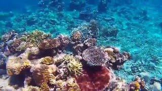
Snorkeling Pulau Lintang, June 5 2015
Video from our first snorkel on our Borneo trip, Pulau Lintang, ...
Video from our first snorkel on our Borneo trip, Pulau Lintang, Anambas Archipeligo, South China Sea. This is all part of the Coral ...
100 Hari Minecraft Pulau Surga Hardcore
Mencari Keberadaan Pulau Ter indah Di Dunia bersama Kapten Lintang dan ...
Mencari Keberadaan Pulau Ter indah Di Dunia bersama Kapten Lintang dan Kapten Dendi, Letsgooooo KASIH AKU KEKUATAN ...
Sore di Antara Pulau Penjang dan Pulau Lintang, Kec. Tambelan, Kepri
pulau dekat pilipina ini masih wilayah indonesia....rute pesawat ke miangas #indonesia #shorts
For Rent | Commercial Shoplot | Lintang Burma, Pulau Tikus, near Wine Shop #sylvialeeproperties
FOR RENT Type: 2 Storey Shophouse Location: Lintang Burma, Pulau ...
FOR RENT Type: 2 Storey Shophouse Location: Lintang Burma, Pulau Tikus, 10250 George Town, Penang. Land: 1400 sq ft ...
pulau lintang (sarolangun)
Jangan Lupa...Like, Comment, Share and Subscribe! IG : jib96 yunusjib.
Jangan Lupa...Like, Comment, Share and Subscribe! IG : jib96 yunusjib.
Pulau Karamian! Pulau administrasi Sumenep yang lebih dekat ke Kalimantan
Pulau karamian termasuk ke wilayah administrasi kabupaten sumenep, ...
Pulau karamian termasuk ke wilayah administrasi kabupaten sumenep, lebih tepatnya di kecamatan masalembu. Pulau karamian ...
Pulau Bulang Lintang, 2 Januari 2013
Liburan team remaja Fresh Shekinah Batam ke Pulau Bulang Lintang dalam ...
Liburan team remaja Fresh Shekinah Batam ke Pulau Bulang Lintang dalam rangka merayakan natal dan tahun baru. Pulau ...
100 Hari Minecraft PULAU BEDROCK Hardcore
Aku, Kapten Lintang dan Kapten Dendi mencoba Bertahan Hidup 100 Hari ...
Aku, Kapten Lintang dan Kapten Dendi mencoba Bertahan Hidup 100 Hari di Pulau yang penuh dengan Block BEDROCK, ...
Satu Pulau Bisa Bohongi Seluruh Dunia?!”
Pulau ini muncul di peta dunia… tapi gak pernah ada. Ilmuwan datang ke ...
Pulau ini muncul di peta dunia… tapi gak pernah ada. Ilmuwan datang ke koordinatnya, dan yang mereka temukan cuma lautan ...
Pulau Bulang Lintang part 2. Kepulauan Riau Indonesia 2023.
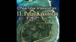
Pulau Kakorotan
omzegeo #surveyandmapping #geografi #infogeografi.
omzegeo #surveyandmapping #geografi #infogeografi.
100 Hari Minecraft Parasite island Hardcore
Aku terjebak Di Pulau yang Terinfeksi Parasite Apocalypse Selama 100 ...
Aku terjebak Di Pulau yang Terinfeksi Parasite Apocalypse Selama 100 Hari. KASIH AKU KEKUATAN 15.000 LIKE++ Dan AKU ...
Lintang Burma Pulau Tikus, commercial 2 storey shophouse, brand new #PenangCommercials
COMMERCIAL FOR RENT Property Type: 2 Storey Shophouse Location: ...
COMMERCIAL FOR RENT Property Type: 2 Storey Shophouse Location: Lintang Burma, Pulau Tikus, ...
Julukan Lima Pulau Besar di Indonesia #shorts
Pulau Sumatera Pulau ini dikenal dengan nama lain yaitu Pulau Percha, ...
Pulau Sumatera Pulau ini dikenal dengan nama lain yaitu Pulau Percha, Andalas, atau Suwarnadwipa (bahasa Sanskerta, yang ...
Pulau Bulang - Batam, Wisata Makam Temenggung Abdul Jamal dan Pusaka Sejarah
tidak hanya perairan selat yang cantik, di Pulau Bulang atau tepatnya ...
tidak hanya perairan selat yang cantik, di Pulau Bulang atau tepatnya Pulau Bulang Lintang 30 menit menggunakan perahu ...
Indonesia is classified as Emerging region: MIKT: Mexico, Indonesia, South Korea, and Turkey – Economies recognized for their development potential and emerging market status. The level of income is Lower middle income.
News – Latest Updates and Headlines from Pulau Lintang
Stay informed with the most recent news and important headlines from Pulau Lintang. Here’s a roundup of the latest developments.
Loading...
Please note: The data used here has been primarily extracted from satellite readings. Deviations from exact values may occur, particularly regarding the height of elevations and population density. Land area and coastline measurements refer to average values at mean high tide.