Pulau Luang
Welcome to Pulau Luang, a Tropical island in the Banda Sea, part of the majestic Pacific Ocean. This guide offers a comprehensive overview of what makes Pulau Luang unique – from its geography and climate to its population, infrastructure, and beyond. Dive into the details:
- Geography and Size: Explore the island’s size and location.
- Climate and Weather: Weather patterns and temperature.
- Topography and Nature: Uncover the natural wonders of the island.
- Infrastructure and Travelling: Insights on reaching, staying, and making the most of your visit.
- News and Headlines: Latest News.
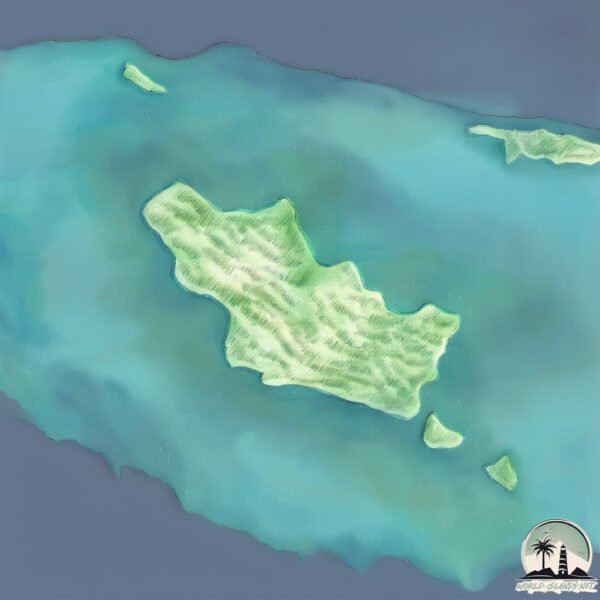
Geography and size of Pulau Luang
Size: 6.535 km²
Coastline: 12.3 km
Ocean: Pacific Ocean
Sea: Banda Sea
Continent: Oceania
Pulau Luang is a Small Island spanning 6.5 km² with a coastline of 12.3 km.
Archipel: Melanesia – A subregion of Oceania in the southwestern Pacific Ocean, including countries like Fiji, Solomon Islands, and Vanuatu, known for their diverse cultures and languages.
Tectonic Plate: Sunda – Extends across Southeast Asia, encompassing parts of the Sunda Shelf, known for its interaction with the Australian Plate, contributing to volcanic activity in Indonesia.
The geographic heart of the island is pinpointed at these coordinates:
Latitude: -8.1781119 / Longitude: 128.7011973
Climate and weather of Pulau Luang
Climate Zone: Tropical
Climate Details: Tropical Savanna, Wet
Temperature: Hot
Climate Characteristics: Defined by distinct wet and dry seasons with high temperatures year-round. Pronounced rainfall occurs during the wet season, while the dry season is marked by drought.
Topography and nature of Pulau Luang
Timezone: UTC+09:00
Timezone places: Asia/Tokyo
Max. Elevation: 117 m
Mean Elevation: 82 m
Vegetation: Agricultural Mosaic
Tree Coverage: 39%
The mean elevation is 82 m. The highest elevation on the island reaches approximately 117 meters above sea level. The island is characterized by Plains: Flat, low-lying lands characterized by a maximum elevation of up to 200 meters. On islands, plains are typically coastal lowlands or central flat areas.
Dominating Vegetation: Agricultural Mosaic
A mix of cropland and natural vegetation, often seen in rural landscapes where agricultural fields are interspersed with patches of natural habitats. Pulau Luang has a tree cover of 39 %.
Vegetation: 7 vegetation zones – Very Highly Diverse Island
Islands in this range are ecological powerhouses, showcasing a wide array of vegetation zones. Each zone, from lush rainforests to arid scrublands, coastal mangroves to mountainous regions, contributes to a complex and interdependent ecosystem. These islands are often hotspots of biodiversity, supporting numerous species and intricate ecological processes.
Infrastructure and Travelling to Pulau Luang
Does the island have a public airport? no.
There is no public and scheduled airport on Pulau Luang. The nearest airport is Jos Orno Imsula Airport, located 86 km away.
Does the island have a major port? no.
There are no major ports on Pulau Luang. The closest major port is SAUMLAKI, approximately 287 km away.
The mean population of Pulau Luang is 18 per km². Pulau Luang is Gently Populated. The island belongs to Indonesia.
Continuing your journey, Pulau Sermata is the next notable island, situated merely km away.
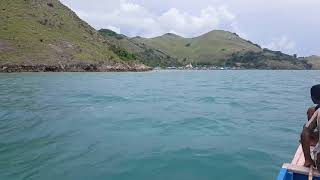
The Luang Island.. amazing view


Indonesia is classified as Emerging region: MIKT: Mexico, Indonesia, South Korea, and Turkey – Economies recognized for their development potential and emerging market status. The level of income is Lower middle income.
News – Latest Updates and Headlines from Pulau Luang
Stay informed with the most recent news and important headlines from Pulau Luang. Here’s a roundup of the latest developments.
Please note: The data used here has been primarily extracted from satellite readings. Deviations from exact values may occur, particularly regarding the height of elevations and population density. Land area and coastline measurements refer to average values at mean high tide.