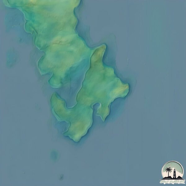
Welcome to Pulau Marege, a Tropical island in the Banda Sea, part of the majestic Pacific Ocean. This guide offers a comprehensive overview of what makes Pulau Marege unique – from its geography and climate to its population, infrastructure, and beyond. Dive into the details:
Geography and size of Pulau Marege
Size: 1.473 km²
Coastline: 8.4 km
Ocean: Pacific Ocean
Sea: Banda Sea
Continent: Asia
Pulau Marege is a Small Island spanning 1.5 km² with a coastline of 8.4 km.
Archipel: Greater Sunda Islands – A group of large islands in Southeast Asia, including Borneo, Sumatra, Java, and Sulawesi, known for their rich biodiversity and cultural diversity.
Tectonic Plate: Sunda – Extends across Southeast Asia, encompassing parts of the Sunda Shelf, known for its interaction with the Australian Plate, contributing to volcanic activity in Indonesia.
The geographic heart of the island is pinpointed at these coordinates:
Latitude: -3.28174544 / Longitude: 122.43445422
Climate and weather of Pulau Marege
Climate Zone: Tropical
Climate Details: Tropical Rainforest Climate
Temperature: Hot
Climate Characteristics: This climate is typified by heavy rainfall throughout the year, high humidity, and consistently high temperatures, leading to lush rainforests and rich biodiversity. Seasonal temperature variations are minimal.
Topography and nature of Pulau Marege
Timezone: UTC+08:00
Timezone places: Australia/Perth
Max. Elevation: 81 m
Mean Elevation: 49 m
Vegetation: Evergreen Needleleaf Forest
Tree Coverage: 100%
The mean elevation is 49 m. The highest elevation on the island reaches approximately 81 meters above sea level. The island is characterized by Plains: Flat, low-lying lands characterized by a maximum elevation of up to 200 meters. On islands, plains are typically coastal lowlands or central flat areas.
Dominating Vegetation: Evergreen Needleleaf Forest
Dominated by evergreen coniferous trees such as pines and firs, which retain their needle-like leaves throughout the year. These forests are often found in cooler climates. Pulau Marege has a tree cover of 100 %.
Vegetation: 3 vegetation zones – Moderately Diverse Island
These islands start to show a broader range of ecological niches. With three vegetation zones, they may offer a mix of ecosystems like coastal areas, inland woods, and perhaps a distinct wetland or dry area. This diversity supports a wider range of flora and fauna, making these islands more ecologically complex than those with minimal diversity.
Infrastructure and Travelling to Pulau Marege
Does the island have a public airport? no.
There is no public and scheduled airport on Pulau Marege. The nearest airport is Haluoleo Airport, located 88 km away.
Does the island have a major port? no.
There are no major ports on Pulau Marege. The closest major port is KENDARI, approximately 77 km away.
The mean population of Pulau Marege is 20 per km². Pulau Marege is Gently Populated. The island belongs to Indonesia.
Continuing your journey, Pulau Labengke is the next notable island, situated merely km away.
Blox Fruits: How to Find Mirage Island & The Blue Gear (2025 Guide)
Welcome to Rao RK Gaming! Your ultimate hub for Roblox Blox Fruits content, tips, live streams, and more. Subscribe and join the ...Blox Fruits: How to Find Mirage Island & The Blue Gear (2025 Guide)
Welcome to Rao RK Gaming! Your ultimate hub for Roblox Blox Fruits ...
Welcome to Rao RK Gaming! Your ultimate hub for Roblox Blox Fruits content, tips, live streams, and more. Subscribe and join the ...
Part 35 | How to spawn mirage island! 🕵️🏝️ #foryou #roblox #bloxfruits #anime #mirage #island
Best Way to Spawn Mirage Island in #bloxfruits
Best Way To Spawn Mirage Island in Blox Fruits #roblox #bloxfurit
Welcome to Rao RK Gaming! Your ultimate hub for Roblox Blox Fruits ...
Welcome to Rao RK Gaming! Your ultimate hub for Roblox Blox Fruits content, tips, guide, and more. Subscribe and join the RAO ...
Best Way To Spawn Mirage Island in Blox Fruits
Welcome to Rao RK Gaming! Your ultimate hub for Roblox Blox Fruits ...
Welcome to Rao RK Gaming! Your ultimate hub for Roblox Blox Fruits content, tips, live streams, and more. Subscribe and join the ...
How to Find Mirage Island Fast in Blox Fruits | Top Tips & Tricks
roblox #rblxadv #ayze #ayzetips.
roblox #rblxadv #ayze #ayzetips.
🏝️How to Find Mirage Island *Fast & Easy* (🌊Blox Fruits) #shorts #bloxfruits #roblox
...
Spawn Mirage and Find Blue Gear Locations Guide - Blox Fruits Update 2025
Spawn Mirage and Find Blue Gear Locations Guide - Blox Fruits Update ...
Spawn Mirage and Find Blue Gear Locations Guide - Blox Fruits Update 2025 ✔️Like and Subscribe! Click the bell and turn ...
How to Find Mirage Island FAST in Blox Fruits Update 26! 🌙 (Easy Spawn Guide)
Want to unlock Mirage Island in Blox Fruits Update 26? In this video, ...
Want to unlock Mirage Island in Blox Fruits Update 26? In this video, I'll show you step-by-step how to increase your spawn ...
Good Mirage Island Stock #bloxfruits #roblox
bloxfruits #roblox #english #gaming #shorts.
bloxfruits #roblox #english #gaming #shorts.
💀Helping everyone in Mirage Island #bloxfruits #mirage #newvideo #bloxfruitsupdate #fyp #viralreel
I found mirage island in just 2nd level #mirage #bloxfruitindian ...
I found mirage island in just 2nd level #mirage #bloxfruitindian #kilvish #killwish #newvideo #viralvideos #mirageisland ...
After so many hours looking for mirage island to find blue gear - Blox Fruits
After so many hours looking for mirage island to find blue gear - Blox ...
After so many hours looking for mirage island to find blue gear - Blox Fruits ✔️Like and Subscribe! Click the bell and turn on ...
Easiest Way to Spawn Mirage Island after Update 26 in Blox Fruits
Learn the easiest and most effective way to spawn Mirage Island after ...
Learn the easiest and most effective way to spawn Mirage Island after Update 26 in Blox Fruits! Join our Discord for Mirage, ...
How To Spawn MIRAGE ISLAND Blox Fruits 2025 Guide
How To Spawn MIRAGE ISLAND Blox Fruits 2025 Guide ✔️Like and ...
How To Spawn MIRAGE ISLAND Blox Fruits 2025 Guide ✔️Like and Subscribe! Click the bell and turn on all notifications!
How To Easily Find Mirage Isalnd Solo in Blox Fruits After New Update
In this video, we'll show you how to easily find Mirage Island solo in ...
In this video, we'll show you how to easily find Mirage Island solo in Blox Fruits after the new update. We'll walk you through a ...
How to Spawn Mirage Island FAST in Blox Fruits (2025 Guide)
Learn the fastest way to spawn Mirage Island in Blox Fruits! Follow ...
Learn the fastest way to spawn Mirage Island in Blox Fruits! Follow this step-by-step guide to increase your chances, avoid ...
*FASTEST* Way To Spawn Mirage Island In Blox Fruits
In this video, I will tell you how to spawn the mirage island and the ...
In this video, I will tell you how to spawn the mirage island and the FASTEST way to make it spawn. ─── SOCIALS ...
How I Found Mirage Island in 2 Minutes After Update 26 in 2025
In this video, I'll show you how I found Mirage Island in just 2 ...
In this video, I'll show you how I found Mirage Island in just 2 minutes after Update 26 in Blox Fruits (2025). This method is fast, ...
How to Find Mirage Island Easily In Blox Fruit
Learn the Easy Way to Spawn Mirage Island Easily In Blox Fruit! This ...
Learn the Easy Way to Spawn Mirage Island Easily In Blox Fruit! This step-by-step guide will walk you through everything you ...
Finding Blue gear and Mirage Island Now Vs Finding Then #bloxfruits #roblox #raceawakening
4 Best Location to Spawn Mirage Island in Blox Fruits #bloxfruits #shorts
Best 4 Location to Spawn Mirage Island in blox fruits ...
Best method to spawn mirage 100% spawn rate || Mirage Island Guide 2025 #bloxfruits #bloxfurit
Make sure to watch full video so you can perform your hunt well Drop a ...
Make sure to watch full video so you can perform your hunt well Drop a like If I helped you :3 Your opinions are appreciated put ...
Fastest Way to Spawn Mirage Island in Blox Fruits
In this video I will show you how to easily you can spawn Mirage ...
In this video I will show you how to easily you can spawn Mirage Island solo in blox fruits. We will start our hunt from the Tiki ...
How to get Blue Gear in Blox Fruits FAST
To get Blue Gear in Blox Fruits, use your mirror fractal on mirage ...
To get Blue Gear in Blox Fruits, use your mirror fractal on mirage island by finding the highest peak and stare at the moon in first ...
How to spawn mirage island in Blox Fruits
How to Spawn Mirage Island in Blox Fruits (Full Guide) In this video, ...
How to Spawn Mirage Island in Blox Fruits (Full Guide) In this video, I'll show you exactly how to spawn Mirage Island in Blox ...
Indonesia is classified as Emerging region: MIKT: Mexico, Indonesia, South Korea, and Turkey – Economies recognized for their development potential and emerging market status. The level of income is Lower middle income.
News – Latest Updates and Headlines from Pulau Marege
Stay informed with the most recent news and important headlines from Pulau Marege. Here’s a roundup of the latest developments.
Loading...
Please note: The data used here has been primarily extracted from satellite readings. Deviations from exact values may occur, particularly regarding the height of elevations and population density. Land area and coastline measurements refer to average values at mean high tide.