Welcome to Pulau Masalembu Besar, a Tropical island in the Java Sea, part of the majestic Pacific Ocean. This guide offers a comprehensive overview of what makes Pulau Masalembu Besar unique – from its geography and climate to its population, infrastructure, and beyond. Dive into the details:
Geography and size of Pulau Masalembu Besar
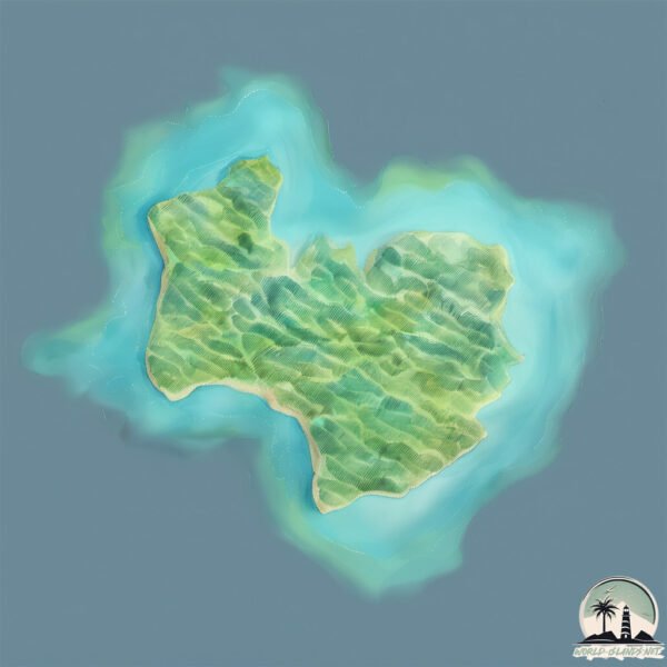
Size: 23.6 km²
Coastline: 29.9 km
Ocean: Pacific Ocean
Sea: Java Sea
Continent: Asia
Pulau Masalembu Besar is a Medium Island spanning 24 km² with a coastline of 30 km.
Archipel: Greater Sunda Islands – A group of large islands in Southeast Asia, including Borneo, Sumatra, Java, and Sulawesi, known for their rich biodiversity and cultural diversity.
Tectonic Plate: Somalia – A large tectonic plate covering the Horn of Africa and parts of the Indian Ocean, known for the East African Rift where it’s splitting away from the African Plate.
The geographic heart of the island is pinpointed at these coordinates:
Latitude: -5.5615841 / Longitude: 114.42365077
Climate and weather of Pulau Masalembu Besar
Climate Zone: Tropical
Climate Details: Tropical Monsoon Climate
Temperature: Hot
Climate Characteristics: Characterized by heavy rainfall, high humidity, and uniformly high temperatures, but with a distinct short dry season. It features a seasonal reversal of prevailing wind directions.
Topography and nature of Pulau Masalembu Besar
Timezone: UTC+07:00
Timezone places: Asia/Jakarta
Max. Elevation: 63 m
Mean Elevation: 19 m
Vegetation: Agricultural Mosaic
Tree Coverage: 47%
The mean elevation is 19 m. The highest elevation on the island reaches approximately 63 meters above sea level. The island is characterized by Plains: Flat, low-lying lands characterized by a maximum elevation of up to 200 meters. On islands, plains are typically coastal lowlands or central flat areas.
Dominating Vegetation: Agricultural Mosaic
A mix of cropland and natural vegetation, often seen in rural landscapes where agricultural fields are interspersed with patches of natural habitats. Pulau Masalembu Besar has a tree cover of 47 %.
Vegetation: 10 vegetation zones – Very Highly Diverse Island
Islands in this range are ecological powerhouses, showcasing a wide array of vegetation zones. Each zone, from lush rainforests to arid scrublands, coastal mangroves to mountainous regions, contributes to a complex and interdependent ecosystem. These islands are often hotspots of biodiversity, supporting numerous species and intricate ecological processes.
Infrastructure and Travelling to Pulau Masalembu Besar
Does the island have a public airport? no.
There is no public and scheduled airport on Pulau Masalembu Besar. The nearest airport is Bawean – Harun Thohir Airport, located 191 km away.
Does the island have a major port? no.
There are no major ports on Pulau Masalembu Besar. The closest major port is POLENG OIL FIELD, approximately 204 km away.
The mean population of Pulau Masalembu Besar is 522 per km². Pulau Masalembu Besar is Densely Populated. The island belongs to Indonesia.
Continuing your journey, Pulau Keramian is the next notable island, situated merely km away.
Pulau Masalembu: harta karun tersembunyi di tengah lautan indonesia!
Pulau Masalembu: harta karun tersembunyi di tengah lautan indonesia! Pulau Masalembu adalah bagian dari Kepulauan ...Pulau Masalembu: harta karun tersembunyi di tengah lautan indonesia!
Pulau Masalembu: harta karun tersembunyi di tengah lautan indonesia! ...
Pulau Masalembu: harta karun tersembunyi di tengah lautan indonesia! Pulau Masalembu adalah bagian dari Kepulauan ...
Suasana desa di pulau Masalembu, Kab Sumenep, Jawa Timur
Masalembu Akan Tenggelam Oleh Abrasi
Masalembu akan tenggelam oleh Abrasi. Keberadaan pulau masalembu ...
Masalembu akan tenggelam oleh Abrasi. Keberadaan pulau masalembu terancam dalam puluhan tahun ke depan. Pasalnya ...
Masalembu Itu di Mana?
Masalembu Itu di Mana?. Pulau Masalembu disebut juga segitiga bermuda ...
Masalembu Itu di Mana?. Pulau Masalembu disebut juga segitiga bermuda Indonesia. Pulau Masalembu dikenal sangat angker.
pulau ini masih wilayah jawa timur #masalembu #subscribe #shorts
Keberagaman di Segitiga Bermudanya Indonesia
Jika anda mendengar nama Pulau Masalembu, mungkin yang pertama kali ...
Jika anda mendengar nama Pulau Masalembu, mungkin yang pertama kali terlintas di pikiran anda adalah segitiga bermuda-nya ...
Trip to Masalembu, pulau Raas Besar, Pulau Masalembu, pulau di segitiga Bermuda Indonesia
Masalembu Island With PERSAPALAS
Kepulauan Masalembu adalah sebuah kepulauan di Laut Jawa dengan tiga ...
Kepulauan Masalembu adalah sebuah kepulauan di Laut Jawa dengan tiga pulau utama: Pulau Masalembu, Pulau ...
Pulau Masalembu ternyata termasuk Jawa Timur
Kepulauan Masalembu di Sumenep Jawa Timur tapi lebih dekat dengan ...
Kepulauan Masalembu di Sumenep Jawa Timur tapi lebih dekat dengan Kalimantan.
Welcome to beach masalembu island.
Jangan nilai dari bentuk abstraknya tapi nilailah dari bentuk ...
Jangan nilai dari bentuk abstraknya tapi nilailah dari bentuk realitanya. Mengenal lebih dekat pulau masalembu.
Pulau keramaian | masalembu
Sholat jumat dipulau kermaian. Waktu berlindung dari cuaca buruk laut jawa.
Sholat jumat dipulau kermaian. Waktu berlindung dari cuaca buruk laut jawa.
Jalan jalan Ke Pantai Sinyal di PULAU MASALEMBU || Healing PART 3 #jalanjalan#pantai
Assalamualaikum,, Halo teman teman kali ini saya akan merekomendasikan ...
Assalamualaikum,, Halo teman teman kali ini saya akan merekomendasikan tempat berlibur ke pantai yang sangat indah yaitu ...
#surabaya to #masalembu, at ship - edyfaerusshometown
Tinggi gelombang di pulau masalembu januari 2021
ini terjadi pada tanggal 30 januari 2021 guyss... di akhir bulan ...
ini terjadi pada tanggal 30 januari 2021 guyss... di akhir bulan sampai awal bulan ke 3 memang perairan masalembu ...
Mayoritas pekerjaan apakah yg berada di pulau masalembu ?
Wisata🏞️ | Kegiatan | Peristiwa | Budaya | Explore | Potret | Kuliner ...
View dari puncak tertinggi masalembu ||Jelajahi Masalembu bagian 1
Kepulauan masalembu adalah kepulauan yang yang berada diujung pulau ...
Kepulauan masalembu adalah kepulauan yang yang berada diujung pulau madura. Pulau masalembu ini mempunyai julukan ...
EKSPEDISI PULAU SEMBILAN DAN MASALEMBU: Melepas Tukik dan Bertemu Hiu - MDC FPK-ULM Channel
Tema Ekspedisi : Aksi nyata dalam mewujudkan Sustainable Development ...
Tema Ekspedisi : Aksi nyata dalam mewujudkan Sustainable Development Goals di Pulau Sembilan dan Masalembu. Kegiatan ...
Perubahan apa saja yang terjadi, jalan jalan Pulau Masalembu
Melihat lebih jauh perkembangan Pulau Masalembu dengan berkendara, ...
Melihat lebih jauh perkembangan Pulau Masalembu dengan berkendara, melihat perubahan apa saja yng terjadi. Infrastruktur ...
MASALEMBO yang Indah pantai Cemara yg original belum terjamah | Pantai Utara hadap TAMPO MAS 2
MASALEMBO yang Indah pantai Cemara yg original belum terjamah. Berikut ...
MASALEMBO yang Indah pantai Cemara yg original belum terjamah. Berikut vlog kami menjelajahi pantai ini di sore hari.
masalembu cuaca exstrim ! air laut mendidih
KRISIS AIR Bersih di Pulau Yang 95% Warganya Punya SAWAH😭⁉️ Berkunjung ke Sepangkur Besar, Sumenep🇮🇩
Bantu PPIT bangun sumur bor untuk warga Sepangkur Besar: ...
Bantu PPIT bangun sumur bor untuk warga Sepangkur Besar: ...
Pelabuhan Masalembu pulau Masalembo, pelabuhan di pulau Masalembu, segitiga Bermuda Indonesia
Fenomena Alam Pulau Masalembu, Sumenep Madura.
Wisata pulau masakambing. kec Masalembu, Kap. sumenep
Salam Lestari....!!!! #masakambing #masalembu #sumenep #Kepulauwan.
Salam Lestari....!!!! #masakambing #masalembu #sumenep #Kepulauwan.
MASALEMBU : Segitiga Pesona Indonesia
[Pulau Masalembu: Segitiga Pesona Indonesia] Kepulauan Masalembu ...
[Pulau Masalembu: Segitiga Pesona Indonesia] Kepulauan Masalembu merupakan wilayah terluar dari Provinsi Jawa Timur yang ...
Indonesia is classified as Emerging region: MIKT: Mexico, Indonesia, South Korea, and Turkey – Economies recognized for their development potential and emerging market status. The level of income is Lower middle income.
News – Latest Updates and Headlines from Pulau Masalembu Besar
Stay informed with the most recent news and important headlines from Pulau Masalembu Besar. Here’s a roundup of the latest developments.
Loading...
Please note: The data used here has been primarily extracted from satellite readings. Deviations from exact values may occur, particularly regarding the height of elevations and population density. Land area and coastline measurements refer to average values at mean high tide.