Pulau Meatimiarang
Welcome to Pulau Meatimiarang, a Tropical island in the Timor Sea, part of the majestic Indian Ocean. This guide offers a comprehensive overview of what makes Pulau Meatimiarang unique – from its geography and climate to its population, infrastructure, and beyond. Dive into the details:
- Geography and Size: Explore the island’s size and location.
- Climate and Weather: Weather patterns and temperature.
- Topography and Nature: Uncover the natural wonders of the island.
- Infrastructure and Travelling: Insights on reaching, staying, and making the most of your visit.
- News and Headlines: Latest News.
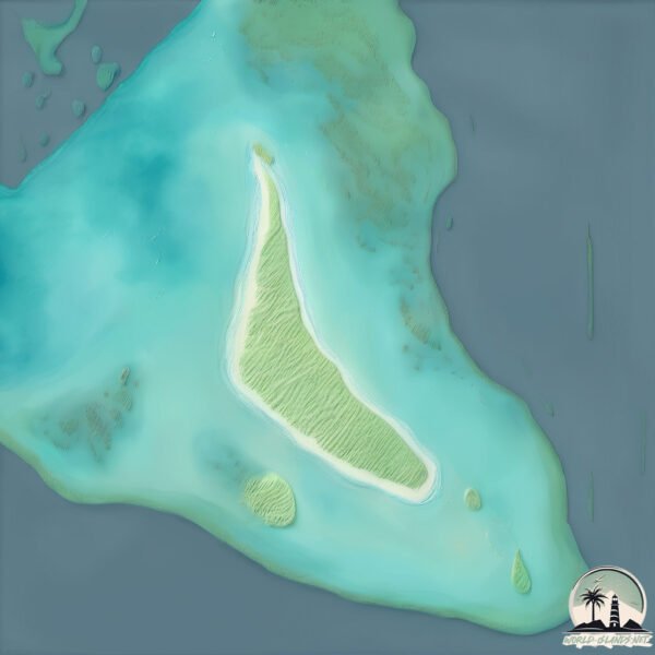
Geography and size of Pulau Meatimiarang
Size: 1.527 km²
Coastline: 7.1 km
Ocean: Indian Ocean
Sea: Timor Sea
Continent: Asia
Pulau Meatimiarang is a Small Island spanning 1.5 km² with a coastline of 7.1 km.
Archipel: Malay Archipelago – The world’s largest archipelago, located between mainland Southeast Asia and Australia, known for its immense biodiversity and cultural diversity.
Tectonic Plate: Pacific – The world’s largest tectonic plate, covering much of the Pacific Ocean, known for the Pacific Ring of Fire with extensive seismic and volcanic activity.
The geographic heart of the island is pinpointed at these coordinates:
Latitude: -8.33442286 / Longitude: 128.50064874
Climate and weather of Pulau Meatimiarang
Climate Zone: Tropical
Climate Details: Tropical Savanna, Wet
Temperature: Hot
Climate Characteristics: Defined by distinct wet and dry seasons with high temperatures year-round. Pronounced rainfall occurs during the wet season, while the dry season is marked by drought.
Topography and nature of Pulau Meatimiarang
Timezone: UTC+09:00
Timezone places: Asia/Tokyo
Max. Elevation: -2 m
Mean Elevation: -14 m
Vegetation: Agricultural Mosaic
Tree Coverage: 39%
The mean elevation is -14 m. Remarkably, this unique island barely emerges above the sea level, showcasing nature’s fascinating interplay with the ocean. The island is characterized by Plains: Flat, low-lying lands characterized by a maximum elevation of up to 200 meters. On islands, plains are typically coastal lowlands or central flat areas.
Dominating Vegetation: Agricultural Mosaic
A mix of cropland and natural vegetation, often seen in rural landscapes where agricultural fields are interspersed with patches of natural habitats. Pulau Meatimiarang has a tree cover of 39 %.
Vegetation: 2 vegetation zones – Low Diversity Island
Islands with two distinct vegetation zones offer slightly more ecological variety. These zones could be due to differences in elevation, moisture, or other environmental factors. While still limited in biodiversity, these islands may offer a contrast between the two zones, such as a coastline with mangroves and an inland area with grassland.
Infrastructure and Travelling to Pulau Meatimiarang
Does the island have a public airport? no.
There is no public and scheduled airport on Pulau Meatimiarang. The nearest airport is Jos Orno Imsula Airport, located 68 km away.
Does the island have a major port? no.
There are no major ports on Pulau Meatimiarang. The closest major port is SAUMLAKI, approximately 313 km away.
The mean population of Pulau Meatimiarang is 18 per km². Pulau Meatimiarang is Gently Populated. The island belongs to Indonesia.
Continuing your journey, Pulau Lakor is the next notable island, situated merely km away.
PULAU MEATIMIARANG - KABUPATEN MALUKU BARAT DAYA (18H)


Indonesia is classified as Emerging region: MIKT: Mexico, Indonesia, South Korea, and Turkey – Economies recognized for their development potential and emerging market status. The level of income is Lower middle income.
News – Latest Updates and Headlines from Pulau Meatimiarang
Stay informed with the most recent news and important headlines from Pulau Meatimiarang. Here’s a roundup of the latest developments.
Please note: The data used here has been primarily extracted from satellite readings. Deviations from exact values may occur, particularly regarding the height of elevations and population density. Land area and coastline measurements refer to average values at mean high tide.