Welcome to Pulau Merak Besar, a Tropical island in the Java Sea, part of the majestic Pacific Ocean. This guide offers a comprehensive overview of what makes Pulau Merak Besar unique – from its geography and climate to its population, infrastructure, and beyond. Dive into the details:
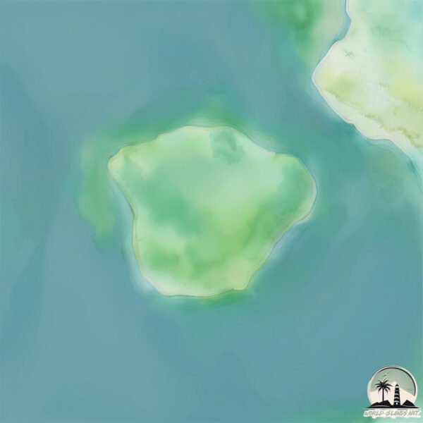
Geography and size of Pulau Merak Besar
Size: 0.483 km²
Coastline: 2.7 km
Ocean: Pacific Ocean
Sea: Java Sea
Continent: Asia
Pulau Merak Besar is a Tiny Island spanning 0.483 km² with a coastline of 2.7 km.
Archipel: Greater Sunda Islands – A group of large islands in Southeast Asia, including Borneo, Sumatra, Java, and Sulawesi, known for their rich biodiversity and cultural diversity.
Tectonic Plate: Sunda – Extends across Southeast Asia, encompassing parts of the Sunda Shelf, known for its interaction with the Australian Plate, contributing to volcanic activity in Indonesia.
The geographic heart of the island is pinpointed at these coordinates:
Latitude: -5.93363193 / Longitude: 105.98956301
Climate and weather of Pulau Merak Besar
Climate Zone: Tropical
Climate Details: Tropical Monsoon Climate
Temperature: Hot
Climate Characteristics: Characterized by heavy rainfall, high humidity, and uniformly high temperatures, but with a distinct short dry season. It features a seasonal reversal of prevailing wind directions.
Topography and nature of Pulau Merak Besar
Timezone: UTC+07:00
Timezone places: Asia/Jakarta
Max. Elevation: 18 m
Mean Elevation: 8 m
Vegetation: Mangrove Forest
Tree Coverage: 70%
The mean elevation is 8 m. The highest elevation on the island reaches approximately 18 meters above sea level. The island is characterized by Plains: Flat, low-lying lands characterized by a maximum elevation of up to 200 meters. On islands, plains are typically coastal lowlands or central flat areas.
Dominating Vegetation: Mangrove Forest
Found in coastal areas and river deltas, these unique wetland ecosystems are adapted to saline conditions and are crucial for coastal protection and biodiversity. Pulau Merak Besar has a tree cover of 70 %.
Vegetation: 2 vegetation zones – Low Diversity Island
Islands with two distinct vegetation zones offer slightly more ecological variety. These zones could be due to differences in elevation, moisture, or other environmental factors. While still limited in biodiversity, these islands may offer a contrast between the two zones, such as a coastline with mangroves and an inland area with grassland.
Infrastructure and Travelling to Pulau Merak Besar
Does the island have a public airport? no.
There is no public and scheduled airport on Pulau Merak Besar. The nearest airport is Soekarno-Hatta International Airport, located 77 km away.
Does the island have a major port? no.
There are no major ports on Pulau Merak Besar. The closest major port is MERAK MAS TERMINAL, approximately 2 km away.
The mean population of Pulau Merak Besar is 2403 per km². Pulau Merak Besar is Densely Populated. The island belongs to Indonesia.
Continuing your journey, Pulau Sebuku is the next notable island, situated merely km away.
Pulau Merak Besar Cilegon Banten || Juli 2025
Di Vidio ini kita akan menjelajahi sebuah pulau yang ada di Sebrang Cilegon Yaitu Pulau Merak Besar, untuk Pintu masuknya ...Pulau Merak Besar Cilegon Banten || Juli 2025
Di Vidio ini kita akan menjelajahi sebuah pulau yang ada di Sebrang ...
Di Vidio ini kita akan menjelajahi sebuah pulau yang ada di Sebrang Cilegon Yaitu Pulau Merak Besar, untuk Pintu masuknya ...
PULAU MERAK BESAR - Indonesia Island Tourism | September 2020 (Under Water View)
One of the island attractions in Cilegon, Banten - Indonesia that is ...
One of the island attractions in Cilegon, Banten - Indonesia that is easy to reach, cheap, beautiful, and comfortable is Merak Besar ...
Liburan Murah Tapi Indah ! Pulau Merak Besar Banten - Viewnya Gak Main- Main
Cara menuju pulau merak tujuan pulau merak besar , pelabuhan merak ...
Cara menuju pulau merak tujuan pulau merak besar , pelabuhan merak cilegon Banten. transportasi KRL Rawa buntu - rangkas ...
3-Hour Train Journey from Jakarta to a Countryside Island , Pulau Merak Besar , Banten
Hi I'm ash , I make vlogs from Indonesia and show you what life here ...
Hi I'm ash , I make vlogs from Indonesia and show you what life here is like. If you enjoy it, don't forget to subscribe for more ...
MODAL RECEH 1 DAY TRIP KE PULAU MERAK BESAR⁉️ INI RUTE DAN BIAYANYA 💸 | PULAU MERAK CILEGON
MODAL RECEH 1 DAY TRIP KE PULAU MERAK BESAR⁉️ INI RUTE DAN BIAYANYA | ...
MODAL RECEH 1 DAY TRIP KE PULAU MERAK BESAR⁉️ INI RUTE DAN BIAYANYA | PULAU MERAK CILEGON Banyak ...
Pulau Merak Besar #shorts #fyp #pulaumerakbesar #merak #cilegon #banten #beach #island #roblox
Liburan Anti Ribet & Anti Pungli! Pulau Merak Besar– Merak Kecil Naik KRL
Liburan murah meriah gak harus jauh dan mahal! Di video ini gue share ...
Liburan murah meriah gak harus jauh dan mahal! Di video ini gue share perjalanan liburan ke Pulau Merak Besar dan Pulau ...
Ke Pulau Merak Besar naik krl | liburan hemat
assalamualaikum liburan kaki ini versi low budget ke pulau di ujung ...
assalamualaikum liburan kaki ini versi low budget ke pulau di ujung banten. yang penting lokasinya bisa di jangkau kereta krl.
EPS : 1 • WAJIB KESINI‼️WISATA BARU‼️CUMA RP. 32 RIBU • TRIP : JAKARTA - PULAU MERAK BESAR
Pulau Merak BESAR ( View Drone Kota Cilegon Project )
PULAUMERAK #MERAK #CILEGON #PULAUMERAKBESAR #ASCNEWSCILEGON #ASCNEWS ...
PULAUMERAK #MERAK #CILEGON #PULAUMERAKBESAR #ASCNEWSCILEGON #ASCNEWS #CILEGON #KOTACILEGON ...
PULAU MERAK BESAR! 🏝️ Surga Tersembunyi Dekat Jakarta (Banten)
PULAU MERAK BESAR! 🏝️ Surga Tersembunyi Dekat Jakarta (Banten) Hai ...
PULAU MERAK BESAR! 🏝️ Surga Tersembunyi Dekat Jakarta (Banten) Hai Travelers! Kali ini kita akan membongkar RAHASIA ...
Liburan murah ke Pulau Merak Besar Banten
Halo Sobat Vista Holic! Kali ini kita akan mengajak kamu untuk ...
Halo Sobat Vista Holic! Kali ini kita akan mengajak kamu untuk jalan-jalan virtual ke salah satu surga tersembunyi di ujung barat ...
Wisata ke Pulau dengan Harga Terjangkau | Pulau Merak Besar
Halo assalamualaikum Apa kabarnya nih temen temen? Semoga dalam ...
Halo assalamualaikum Apa kabarnya nih temen temen? Semoga dalam keadaan sehat selalu ya Di video kali ini, saya ...
PP Dari Jakarta Ke Pulau Merak Besar || Termasuk Tempat Wisata Murah di Cilegon Banten
Video kali ini explore pulau merak besar dan ini perjalanan PP Jakarta ...
Video kali ini explore pulau merak besar dan ini perjalanan PP Jakarta merak Contact Business :
phillipdachi@gmail.com ...
Pulau Merak Besar #pulaumerakkecil #pulaumerakbesar #wisata #banten #cilegon #fypage #shorts
Pulau Merak Besar #thestory #pulaumerakbesar #cilegon
Pulau Merak Besar Banten
Ada yang bisa tebak ini dimana? Komen yah, makasih #visitbanten ...
Ada yang bisa tebak ini dimana? Komen yah, makasih #visitbanten #explorebanten #banten #cilegon #cilegonbanten.
Pulau Merak Besar | Kemping | Paijo geger ngajak pulang...
Nyoba record pulau kecil merak cilegon pake DJI Mini SE
DRONE DJI MIINI SE MUSIC : Weezer - Island In The Sun.
DRONE DJI MIINI SE MUSIC : Weezer - Island In The Sun.
LIBURAN KE PULAU MERAK BESAR, GAPAKE MAHAL! #foryou #merak #holiday #pantai #wisata
Akses dari dan ke Stasiun Merak, tinggal naik angkot merah. Cuma Rp 5.000.
Akses dari dan ke Stasiun Merak, tinggal naik angkot merah. Cuma Rp 5.000.
Trip Mancing Di Pulau Merak Besar
Pulau merak besar berlokasi di merak cilegon banten #angler #fishing ...
Pulau merak besar berlokasi di merak cilegon banten #angler #fishing #mamcingliar #mancingmania #pulaumerakbesar #merak ...
Pulau merak besar destinasi yang wajib kalian kunjungi
Ke Pulau merak besar naik krl. abis berapa???
Pulau merak besar🏝️ #pulaumerakbesar #fyp #foryou
PULAU MERAK BESAR POV Naik Perahu 🏝️⛵ #shorts
PULAU MERAK BESAR POV Naik Perahu. Pulang pergi Rp 20ribu Pulau Merak ...
PULAU MERAK BESAR POV Naik Perahu. Pulang pergi Rp 20ribu Pulau Merak Besar, Naik Perahu, POV, Pulang pergi, Murah, ...
Indonesia is classified as Emerging region: MIKT: Mexico, Indonesia, South Korea, and Turkey – Economies recognized for their development potential and emerging market status. The level of income is Lower middle income.
News – Latest Updates and Headlines from Pulau Merak Besar
Stay informed with the most recent news and important headlines from Pulau Merak Besar. Here’s a roundup of the latest developments.
Loading...
Please note: The data used here has been primarily extracted from satellite readings. Deviations from exact values may occur, particularly regarding the height of elevations and population density. Land area and coastline measurements refer to average values at mean high tide.