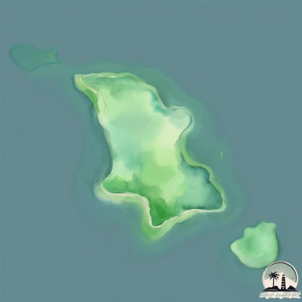
Pulau Nanaka
Welcome to Pulau Nanaka, a Tropical island in the Banda Sea, part of the majestic Pacific Ocean. This guide offers a comprehensive overview of what makes Pulau Nanaka unique – from its geography and climate to its population, infrastructure, and beyond. Dive into the details:
- Geography and Size: Explore the island’s size and location.
- Climate and Weather: Weather patterns and temperature.
- Topography and Nature: Uncover the natural wonders of the island.
- Infrastructure and Travelling: Insights on reaching, staying, and making the most of your visit.
- News and Headlines: Latest News.
Geography and size of Pulau Nanaka
Size: 0.891 km²
Coastline: 4.7 km
Ocean: Pacific Ocean
Sea: Banda Sea
Continent: Asia
Pulau Nanaka is a Tiny Island spanning 0.891 km² with a coastline of 4.7 km.
Archipel: Greater Sunda Islands – A group of large islands in Southeast Asia, including Borneo, Sumatra, Java, and Sulawesi, known for their rich biodiversity and cultural diversity.
Tectonic Plate: Molucca Sea – A small tectonic plate in the Molucca Sea in Indonesia, characterized by complex interactions with the surrounding Pacific, Eurasian, and Australian plates. Known for seismic activity and the formation of volcanic arcs.
The geographic heart of the island is pinpointed at these coordinates:
Latitude: -1.93615613 / Longitude: 121.48602248
Climate and weather of Pulau Nanaka
Climate Zone: Tropical
Climate Details: Tropical Rainforest Climate
Temperature: Hot
Climate Characteristics: This climate is typified by heavy rainfall throughout the year, high humidity, and consistently high temperatures, leading to lush rainforests and rich biodiversity. Seasonal temperature variations are minimal.
Topography and nature of Pulau Nanaka
Timezone: UTC+08:00
Timezone places: Australia/Perth
Max. Elevation: -4 m
Mean Elevation: -6 m
Vegetation: Evergreen Needleleaf Forest
Tree Coverage: 87%
The mean elevation is -6 m. Remarkably, this unique island barely emerges above the sea level, showcasing nature’s fascinating interplay with the ocean. The island is characterized by Plains: Flat, low-lying lands characterized by a maximum elevation of up to 200 meters. On islands, plains are typically coastal lowlands or central flat areas.
Dominating Vegetation: Evergreen Needleleaf Forest
Dominated by evergreen coniferous trees such as pines and firs, which retain their needle-like leaves throughout the year. These forests are often found in cooler climates. Pulau Nanaka has a tree cover of 87 %.
Vegetation: 3 vegetation zones – Moderately Diverse Island
These islands start to show a broader range of ecological niches. With three vegetation zones, they may offer a mix of ecosystems like coastal areas, inland woods, and perhaps a distinct wetland or dry area. This diversity supports a wider range of flora and fauna, making these islands more ecologically complex than those with minimal diversity.
Infrastructure and Travelling to Pulau Nanaka
Does the island have a public airport? no.
There is no public and scheduled airport on Pulau Nanaka. The nearest airport is Maleo Airport, located 35 km away.
Does the island have a major port? no.
There are no major ports on Pulau Nanaka. The closest major port is KOLONODALE, approximately 17 km away.
The mean population of Pulau Nanaka is 20 per km². Pulau Nanaka is Gently Populated. The island belongs to Indonesia.
Continuing your journey, Sulawesi is the next notable island, situated merely km away.
Pasir Panjang Nanaka Island | Kaka Ai Vlog


Indonesia is classified as Emerging region: MIKT: Mexico, Indonesia, South Korea, and Turkey – Economies recognized for their development potential and emerging market status. The level of income is Lower middle income.
News – Latest Updates and Headlines from Pulau Nanaka
Stay informed with the most recent news and important headlines from Pulau Nanaka. Here’s a roundup of the latest developments.
- Indonesian army deploys snipers on key highway to safeguard Eid exodus - Arab News PKby "indonesia" - Google News on 11 March 2026
Indonesian army deploys snipers on key highway to safeguard Eid exodus Arab News PK
- Taiwan, Indonesia trade deals to open more doors for U.S. pork - National Hog Farmerby "indonesia" - Google News on 11 March 2026
Taiwan, Indonesia trade deals to open more doors for U.S. pork National Hog Farmer
- B50 or B60: Stagnant Palm Oil Output Can Hamper Indonesia’s Biodiesel Dream - Jakarta Globeby "indonesia" - Google News on 11 March 2026
B50 or B60: Stagnant Palm Oil Output Can Hamper Indonesia’s Biodiesel Dream Jakarta Globe
- Indonesia president wants sovereign fund Danantara to have 5% return on assets - marketscreener.comby "indonesia" - Google News on 11 March 2026
Indonesia president wants sovereign fund Danantara to have 5% return on assets marketscreener.com
- Everywhere Insiders 37: Saudi Enrichment, IEEPA Tariffs, and Indonesia Nickel - The Good Men Projectby "indonesia" - Google News on 11 March 2026
Everywhere Insiders 37: Saudi Enrichment, IEEPA Tariffs, and Indonesia Nickel The Good Men Project
- South Asian destinations draw rising interest from Indonesian travellers - TTG Asiaby "indonesia" - Google News on 11 March 2026
South Asian destinations draw rising interest from Indonesian travellers TTG Asia
- Algarve ‘killer nurse’ may dodge deportation from Indonesia - Portugal Residentby "indonesia" - Google News on 11 March 2026
Algarve ‘killer nurse’ may dodge deportation from Indonesia Portugal Resident
- 2026/17 “Youth’s Solidarity Beyond Borders: What Encourages Indonesian Muslim Students to Boycott Israel?” by Iim Halimatusa’diyah and Aptiani Nur Jannah - ISEAS-Yusof Ishakby "indonesia" - Google News on 11 March 2026
2026/17 “Youth’s Solidarity Beyond Borders: What Encourages Indonesian Muslim Students to Boycott Israel?” by Iim Halimatusa’diyah and Aptiani Nur Jannah ISEAS-Yusof Ishak
- Amar Bank empowers MSMEs empowerment to promote Indonesia’s digital economy - Independent Observerby "indonesia" - Google News on 11 March 2026
Amar Bank empowers MSMEs empowerment to promote Indonesia’s digital economy Independent Observer
- Freeport Indonesia employee shot dead at Papua’s Grasberg mine - TimesLIVEby "indonesia" - Google News on 11 March 2026
Freeport Indonesia employee shot dead at Papua’s Grasberg mine TimesLIVE
Please note: The data used here has been primarily extracted from satellite readings. Deviations from exact values may occur, particularly regarding the height of elevations and population density. Land area and coastline measurements refer to average values at mean high tide.