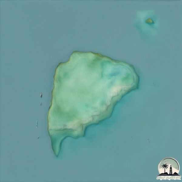
Welcome to Pulau Peli, a Tropical island in the South Pacific Ocean, part of the majestic Pacific Ocean. This guide offers a comprehensive overview of what makes Pulau Peli unique – from its geography and climate to its population, infrastructure, and beyond. Dive into the details:
Geography and size of Pulau Peli
Size: 2.099 km²
Coastline: 5.9 km
Ocean: Pacific Ocean
Sea: South Pacific Ocean
Continent: Oceania
Pulau Peli is a Small Island spanning 2.1 km² with a coastline of 5.9 km.
Archipel: Melanesia – A subregion of Oceania in the southwestern Pacific Ocean, including countries like Fiji, Solomon Islands, and Vanuatu, known for their diverse cultures and languages.
Tectonic Plate: Sunda – Extends across Southeast Asia, encompassing parts of the Sunda Shelf, known for its interaction with the Australian Plate, contributing to volcanic activity in Indonesia.
The geographic heart of the island is pinpointed at these coordinates:
Latitude: -1.37943702 / Longitude: 130.92338112
Climate and weather of Pulau Peli
Climate Zone: Tropical
Climate Details: Tropical Rainforest Climate
Temperature: Hot
Climate Characteristics: This climate is typified by heavy rainfall throughout the year, high humidity, and consistently high temperatures, leading to lush rainforests and rich biodiversity. Seasonal temperature variations are minimal.
Topography and nature of Pulau Peli
Timezone: UTC+09:00
Timezone places: Asia/Tokyo
Max. Elevation: 19 m
Mean Elevation: 16 m
Vegetation: Mangrove Forest
Tree Coverage: 99%
The mean elevation is 16 m. The highest elevation on the island reaches approximately 19 meters above sea level. The island is characterized by Plains: Flat, low-lying lands characterized by a maximum elevation of up to 200 meters. On islands, plains are typically coastal lowlands or central flat areas.
Dominating Vegetation: Mangrove Forest
Found in coastal areas and river deltas, these unique wetland ecosystems are adapted to saline conditions and are crucial for coastal protection and biodiversity. Pulau Peli has a tree cover of 99 %.
Vegetation: 4 vegetation zones – Diverse Island
Four distinct vegetation zones mark these islands as ecologically diverse. They might feature varied landscapes such as forests, beaches, grasslands, and rocky areas. Such diversity reflects the island’s complex ecological interactions and varied habitats, which can support a rich array of wildlife and plant species.
Infrastructure and Travelling to Pulau Peli
Does the island have a public airport? no.
There is no public and scheduled airport on Pulau Peli. The nearest airport is Domine Eduard Osok Airport, located 66 km away.
Does the island have a major port? no.
There are no major ports on Pulau Peli. The closest major port is SALAWATI, approximately 6 km away.
The mean population of Pulau Peli is 26 per km². Pulau Peli is Gently Populated. The island belongs to Indonesia.
Continuing your journey, Salawati is the next notable island, situated merely km away.
#SiapaPergiDiaMati | Official 'PULAU' International Trailer | In Cinema 9 MARCH 2023 |
This is an INTERNATIONAL TRAILER Version PULAU | Malaysia's Supernatural Thriller Film | 9 March 2023 Officially di ...#SiapaPergiDiaMati | Official 'PULAU' International Trailer | In Cinema 9 MARCH 2023 |
This is an INTERNATIONAL TRAILER Version PULAU | Malaysia's ...
This is an INTERNATIONAL TRAILER Version PULAU | Malaysia's Supernatural Thriller Film | 9 March 2023 Officially di ...
PULAU (Official Trailer) - Di Pawagam 9 MAC 2023
Percutian sekumpulan anak muda bertukar menjadi mimpi ngeri yang tidak ...
Percutian sekumpulan anak muda bertukar menjadi mimpi ngeri yang tidak berkesudahan selepas kalah dalam pertaruhan .
Pulau (2023) Horror Movie Recap | Horror Recap | Movie Recap Horror
Pulau (2023) Horror Movie Recap | Horror Recap | Movie Recap Horror A ...
Pulau (2023) Horror Movie Recap | Horror Recap | Movie Recap Horror A group's island dare turns into a fight for survival when ...
Pulau (2023) Movie Explained in English | Pulau: Witch Curse Island Story Summary
In this video, we dive deep into the terrifying world of Pulau (2023), ...
In this video, we dive deep into the terrifying world of Pulau (2023), a chilling horror film about a cursed island haunted by a ...
🎥 Pulau (2023 Movie)
Pulau (2023 Movie) 1hr 54mins • Horror/Adventure 🎞️ A group of friends ...
Pulau (2023 Movie) 1hr 54mins • Horror/Adventure 🎞️ A group of friends on vacation set out to explore a mysterious island ...
Pulau (2023) Horror Movie Explained in Hindi/Urdu | Haunted Island Full Story | Witch Curse Mystery
Pulau (2023) Horror Movie Explained in Hindi/Urdu | Haunted Island ...
Pulau (2023) Horror Movie Explained in Hindi/Urdu | Haunted Island Full Story | Witch Curse Mystery Friends, today we bring you ...
🎥 Pulau — 2023 #movierecap
Pulau is a 2023 Malaysian Malay-language supernatural horror film ...
Pulau is a 2023 Malaysian Malay-language supernatural horror film directed by Euho. It stars Alif Satar, Amelia Henderson, Ikmal ...
Found Moana Island on Google Earth! #googleearth #shorts
$1 vs $250,000,000 Private Island!
Watch until the end to see how crazy the last island is Play my ALL ...
Watch until the end to see how crazy the last island is Play my ALL NEW MrBeast's Disco Dop level in Stumble Guys today!
Fishermen's Terrifying Encounter with the Sentinelese Tribe
Fishermen's Terrifying Encounter with the Sentinelese Tribe ...
Fishermen's Terrifying Encounter with the Sentinelese Tribe Subscribe!: @MostAmazingTop10 #northsentinelisland #theories ...
Te Fiti in real life ✨ #disney #shorts #moana #mountains
Life on Pitcairn Island - home of the descendants of the mutineers from HMS Bounty
Watch the three-part Britain's Treasure Islands documentary series on ...
Watch the three-part Britain's Treasure Islands documentary series on BBC FOUR, starting Tue 12 Apr 2016 21:00. (repeated Wed ...
Terjebak Di Pulau Terkutuk Untuk Selama Lamanya❗Film Horror PULAU 2023
TERJEBAK DIPULAU TERKUTUK UNTUK SELAMA LAMANYA❗FILM HORROR PULAU 2023 ...
TERJEBAK DIPULAU TERKUTUK UNTUK SELAMA LAMANYA❗FILM HORROR PULAU 2023 Kali ini kita akan membahas alur ...
Te fiti real island from Moana
Bertahan hidup di pulau tidak berpenghuni #cuplikanfilm
gadis ini sudah kelaparan selama 10 hari. Setelah kerja keras, ia ...
gadis ini sudah kelaparan selama 10 hari. Setelah kerja keras, ia berhasil menangkap beberapa ikan kecil. Tapi alih-alih ...
Bissagos Islands, on the Mysterious Islands of West Africa
We invite you to discover the Bissagos Islands, an isolated territory ...
We invite you to discover the Bissagos Islands, an isolated territory of Guinee Bissau, in West Africa. These sacred lands resemble ...
The Strange and Curious Galapagos Island Mystery
Today we look at the almost inconceivable events that took place on ...
Today we look at the almost inconceivable events that took place on The Galapagos Islands in the early 1930's, events that are ...
Thomas go to the Island of Sodor Fallout ☢️😱 #thomasanimation
Please subscribe, like and poor every engines #Shorts ...
Please subscribe, like and poor every engines #Shorts #ThomasTheTankEngine #ThomasAnimation.
🌊 Life of Pi – The Miracle Island 🦁🌴
Adrift at sea with Richard Parker the tiger, Pi is on the brink of ...
Adrift at sea with Richard Parker the tiger, Pi is on the brink of collapse—food long gone, sickness setting in, and even the mighty ...
Sodor fallout #flipaclip #animation #2d #shorts
Hancock-Pacific Galapagos Expedition: The Empress of the Galapagos, 1933-1935
WARNING: The following video contains images of human remains, which ...
WARNING: The following video contains images of human remains, which some viewers may find disturbing. The following clip, is ...
🦖 Dinosaur Island Adventure | Fluffy Pobi and Fluffy Petty 🧼🚿
pororo #pororomovie #pororothemovie #kids #animation ...
pororo #pororomovie #pororothemovie #kids #animation #dinosaurislandadventure #shorts #funny #shortsvideo ...
Indonesia is classified as Emerging region: MIKT: Mexico, Indonesia, South Korea, and Turkey – Economies recognized for their development potential and emerging market status. The level of income is Lower middle income.
News – Latest Updates and Headlines from Pulau Peli
Stay informed with the most recent news and important headlines from Pulau Peli. Here’s a roundup of the latest developments.
Loading...
Please note: The data used here has been primarily extracted from satellite readings. Deviations from exact values may occur, particularly regarding the height of elevations and population density. Land area and coastline measurements refer to average values at mean high tide.