Welcome to Pulau Plum, a Tropical island in the Halmahera Sea, part of the majestic Pacific Ocean. This guide offers a comprehensive overview of what makes Pulau Plum unique – from its geography and climate to its population, infrastructure, and beyond. Dive into the details:
Geography and size of Pulau Plum
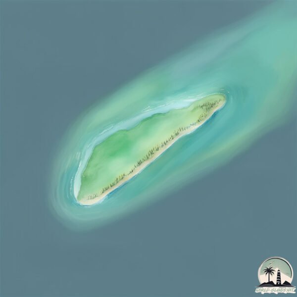
Size: 0.254 km²
Coastline: 2.4 km
Ocean: Pacific Ocean
Sea: Halmahera Sea
Continent: Oceania
Pulau Plum is a Tiny Island spanning 0.254 km² with a coastline of 2.4 km.
Archipel: Melanesia – A subregion of Oceania in the southwestern Pacific Ocean, including countries like Fiji, Solomon Islands, and Vanuatu, known for their diverse cultures and languages.
Tectonic Plate: Birds Head – Also known as the Bird’s Head Plate, it is a small tectonic plate in the vicinity of the Bird’s Head Peninsula in West Papua. The plate is noted for its interactions with the Pacific, Australian, and Philippine Sea plates, contributing to the geological complexity of the region.
The geographic heart of the island is pinpointed at these coordinates:
Latitude: 0.71065939 / Longitude: 128.52077397
Climate and weather of Pulau Plum
Climate Zone: Tropical
Climate Details: Tropical Rainforest Climate
Temperature: Hot
Climate Characteristics: This climate is typified by heavy rainfall throughout the year, high humidity, and consistently high temperatures, leading to lush rainforests and rich biodiversity. Seasonal temperature variations are minimal.
Topography and nature of Pulau Plum
Timezone: UTC+09:00
Timezone places: Asia/Tokyo
Max. Elevation: -15 m
Mean Elevation: -17 m
Vegetation: Evergreen Broadleaf Forest
Tree Coverage: 83%
The mean elevation is -17 m. Remarkably, this unique island barely emerges above the sea level, showcasing nature’s fascinating interplay with the ocean. The island is characterized by Plains: Flat, low-lying lands characterized by a maximum elevation of up to 200 meters. On islands, plains are typically coastal lowlands or central flat areas.
Dominating Vegetation: Evergreen Broadleaf Forest
Characterized by dense, lush canopies of broadleaf trees that retain their leaves year-round. These forests are typically found in tropical and subtropical regions and are known for their high biodiversity. Pulau Plum has a tree cover of 83 %.
Vegetation: 1 vegetation zones – Minimal Diversity Island
These islands exhibit the most basic level of ecological diversity, often characterized by a single dominant vegetation type. This could be due to extreme environmental conditions, limited land area, or significant human impact. They represent unique ecosystems where specific species have adapted to thrive in these singular environments.
Infrastructure and Travelling to Pulau Plum
Does the island have a public airport? no.
There is no public and scheduled airport on Pulau Plum. The nearest airport is Buli Airport, located 28 km away.
Does the island have a major port? no.
There are no major ports on Pulau Plum. The closest major port is PATANI, approximately 46 km away.
The mean population of Pulau Plum is 17 per km². Pulau Plum is Gently Populated. The island belongs to Indonesia.
Continuing your journey, Pulau Sayafi is the next notable island, situated merely km away.
Waterparks "Plum Island"
Plum Island” off Waterparks' debut album, Double Dare, available now. Find CDs + merch at http://waterparks.merchnow.com or ...Waterparks "Plum Island"
Plum Island” off Waterparks' debut album, Double Dare, available now. ...
Plum Island is Where Science, Secrets, and Conspiracies Collide #plumisland #lymedisease #history
Plum Island, a federally owned research site off the Connecticut ...
Plum Island, a federally owned research site off the Connecticut coast, has a long and complex history. Once home to Cold ...
Plum Island Horror : More of a Bad Thing
Join this channel to get access to perks: ...
WATERPARKS: PLUM ISLAND
TICKETS FOR OUR FIRST US HEADLINER ARE ON SALE NOW! Tickets: ...
Why New York's Plum Island Is Totally Forbidden: Secrets of the Mysterious Island
Plum Island, New York, has been shrouded in mystery for over 50 years. ...
Plum Island, New York, has been shrouded in mystery for over 50 years. From secret animal disease research to conspiracy ...
No one is allowed to visit this island
no one is allowed to visit this island near New York Plum Island ...
no one is allowed to visit this island near New York Plum Island Animal Disease Center was established in 1954 with the primary ...
Plum Island Lab | America's Most Secret: Structures
Plum Island is a hot spot for serenity off the coast of Mass.
Plum Island is a hot spot for serenity off the coast of Mass. ...
Plum Island is a hot spot for serenity off the coast of Mass. Subscribe to WCVB on YouTube now for more:
http://bit.ly/1e8lAMZ Get ...
The Plum Island Experiments: What Really Happened at Lab 257?
PlumIsland #Lab257 #AmericasStrangestHistory Based off a bestselling ...
PlumIsland #Lab257 #AmericasStrangestHistory Based off a bestselling book "Lab 257." Just eight miles off the coast of ...
They Tried to Create Monsters on Plum Island
Plum Island, a remote facility off the coast of New York, became one ...
Plum Island, a remote facility off the coast of New York, became one of America's most secretive research centers during the Cold ...
Why New York's Plum Island is Totally Forbidden
Plum Island, located off the northeastern coast of Long Island, New ...
Plum Island, located off the northeastern coast of Long Island, New York, has a rich history spanning centuries. Originally known ...
Is This How The World Will End? The Mystery of Plum Island
Is This How The World Will End? The mystery of Plum Island #mystery ...
Is This How The World Will End? The mystery of Plum Island #mystery #scary #podcast #scarystories In tonights Podcast we talk ...
Sea Change: Protecting Plum Island
Plum Island is a narrow, 11-mile long stretch of sand called a barrier ...
Plum Island is a narrow, 11-mile long stretch of sand called a barrier island. Barrier islands protect the mainland coast, preserve ...
Press Members Get An Inside Look At The Secretive Plum Island Animal Disease Center
By Video Journalist Waldo Cabrera Members of The Long Island Press ...
By Video Journalist Waldo Cabrera Members of The Long Island Press Club were invited for a tour of the mysterious Plum Island ...
Plum Island Under Voluntary Evacuation
Plum Island residents is under a voluntary evacuation to ensure their ...
Plum Island residents is under a voluntary evacuation to ensure their safety during the Nor'Easter. WBZ-TV's Gary Brode reports.
Plum Island
Provided to YouTube by Believe SAS Plum Island · Peter Herbolzheimer ...
Provided to YouTube by Believe SAS Plum Island · Peter Herbolzheimer Rhythm Combination & Brass Friends and Silhouettes ...
Human remains found on Plum Island beach
Investigators conducted an extensive search of Plum Island beach on ...
Investigators conducted an extensive search of Plum Island beach on Sunday after human bones were found washed up on shore ...
Discover Plum Island: Beaches, Beauty, and Mystique
Uncover the unique charm of Plum Island and its distinctive aspen-like ...
Uncover the unique charm of Plum Island and its distinctive aspen-like shape. Explore the stunning beaches and find out why this ...
Plum Island
Plum Island: Biological Linchpin of an Archipelago Louise Harrison, ...
Plum Island: Biological Linchpin of an Archipelago Louise Harrison, New York Outreach Coordinator, Plum Island Campaign, ...
Plum Island: A Barrier Beach Under Stress Episode 1
Pilot episode for a possible series of videos sponsored by Storm Surge ...
Pilot episode for a possible series of videos sponsored by Storm Surge to show the effects of extreme weather and sea level rise ...
7 people transported to hospital after incident at Plum Island Animal Disease Center
7 staff members were hospitalized after an incident on Plum Island in ...
7 staff members were hospitalized after an incident on Plum Island in New York. For more Local News from WFSB: ...
Inside America's Only Foreign Animal Disease Laboratory: Plum Island
About the size of Central Park and a few miles off the coast of Long ...
About the size of Central Park and a few miles off the coast of Long Island, Plum Island houses the nation's only laboratory that is ...
Woman found dead in Plum Island
The body of an adult female was discovered on Plum Island on Sunday ...
The body of an adult female was discovered on Plum Island on Sunday morning. Subscribe to WCVB on YouTube now for more: ...
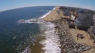
Plum Island Point Live Cam
Indonesia is classified as Emerging region: MIKT: Mexico, Indonesia, South Korea, and Turkey – Economies recognized for their development potential and emerging market status. The level of income is Lower middle income.
News – Latest Updates and Headlines from Pulau Plum
Stay informed with the most recent news and important headlines from Pulau Plum. Here’s a roundup of the latest developments.
Loading...
Please note: The data used here has been primarily extracted from satellite readings. Deviations from exact values may occur, particularly regarding the height of elevations and population density. Land area and coastline measurements refer to average values at mean high tide.