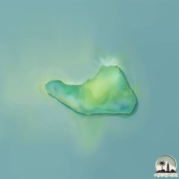
Welcome to Pulau Putri, a Tropical island in the South China Sea, part of the majestic Pacific Ocean. This guide offers a comprehensive overview of what makes Pulau Putri unique – from its geography and climate to its population, infrastructure, and beyond. Dive into the details:
Geography and size of Pulau Putri
Size: 0.11 km²
Coastline: 1.4 km
Ocean: Pacific Ocean
Sea: South China Sea
Continent: Asia
Pulau Putri is a Tiny Island spanning 0.11 km² with a coastline of 1.4 km.
Archipel: Greater Sunda Islands – A group of large islands in Southeast Asia, including Borneo, Sumatra, Java, and Sulawesi, known for their rich biodiversity and cultural diversity.
Tectonic Plate: Sunda – Extends across Southeast Asia, encompassing parts of the Sunda Shelf, known for its interaction with the Australian Plate, contributing to volcanic activity in Indonesia.
The geographic heart of the island is pinpointed at these coordinates:
Latitude: -1.70440413 / Longitude: 105.71146553
Climate and weather of Pulau Putri
Climate Zone: Tropical
Climate Details: Tropical Rainforest Climate
Temperature: Hot
Climate Characteristics: This climate is typified by heavy rainfall throughout the year, high humidity, and consistently high temperatures, leading to lush rainforests and rich biodiversity. Seasonal temperature variations are minimal.
Topography and nature of Pulau Putri
Timezone: UTC+07:00
Timezone places: Asia/Jakarta
Max. Elevation: 1 m
Mean Elevation: 1 m
Vegetation: Mangrove Forest
Tree Coverage: 69%
The mean elevation is 1 m. The highest elevation on the island reaches approximately 1 meters above sea level. The island is characterized by Plains: Flat, low-lying lands characterized by a maximum elevation of up to 200 meters. On islands, plains are typically coastal lowlands or central flat areas.
Dominating Vegetation: Mangrove Forest
Found in coastal areas and river deltas, these unique wetland ecosystems are adapted to saline conditions and are crucial for coastal protection and biodiversity. Pulau Putri has a tree cover of 69 %.
Vegetation: 1 vegetation zones – Minimal Diversity Island
These islands exhibit the most basic level of ecological diversity, often characterized by a single dominant vegetation type. This could be due to extreme environmental conditions, limited land area, or significant human impact. They represent unique ecosystems where specific species have adapted to thrive in these singular environments.
Infrastructure and Travelling to Pulau Putri
Does the island have a public airport? no.
There is no public and scheduled airport on Pulau Putri. The nearest airport is Depati Amir Airport, located 69 km away.
Does the island have a major port? no.
There are no major ports on Pulau Putri. The closest major port is BLINYU, approximately 11 km away.
The mean population of Pulau Putri is 82 per km². Pulau Putri is Gently Populated. The island belongs to Indonesia.
Continuing your journey, Bangka is the next notable island, situated merely km away.
Jalan jalan ke pulau putri di kepulauan seribu 2021
jalan jalan privite ke pulau putri bersama keluarga kakak, seru banget, semua happy, main di laut 2 hari gak berasa, rekomended ...Jalan jalan ke pulau putri di kepulauan seribu 2021
jalan jalan privite ke pulau putri bersama keluarga kakak, seru ...
jalan jalan privite ke pulau putri bersama keluarga kakak, seru banget, semua happy, main di laut 2 hari gak berasa, rekomended ...
PULAU PUTRI | Wisata Pulau Seribu
Pulau Putri adalah salah satu pulau dari Kepulauan Seribu yang ...
Pulau Putri adalah salah satu pulau dari Kepulauan Seribu yang dikelola sebagai sebuah Resort, Pulau Putri mempunyai ...
Liburan ke Pulau Putri Kepulauan Seribu
Pulau Putri merupakan salah 1 pulau di Kepulauan Seribu. Panorama di ...
Pulau Putri merupakan salah 1 pulau di Kepulauan Seribu. Panorama di darat dan lautnya sangatlah indah. Yuk saksikan ...
Liburan ke Pulau Putri di Kepulauan Seribu | JELANG SIANG
JelangSiangTTV | #PulauPutri | #KepulauanSeribu | Dok : Jelang Siang ...
JelangSiangTTV | #PulauPutri | #KepulauanSeribu | Dok : Jelang Siang Trans TV.
Beauty Resort Pulau Putri 🏝️
Keindahan Pulau Putri Resort tiada tanding di Pulau Seribu bagian ...
Keindahan Pulau Putri Resort tiada tanding di Pulau Seribu bagian Utara. Wisatawan local maupun mancanegara sering sekali ...
Outing Pulau putri 2 hari 1 malam #kepulauan seribu
Kegiatan tahunan kali ini kita ke pulau putri kepulauan seribu. 2 Hari ...
Kegiatan tahunan kali ini kita ke pulau putri kepulauan seribu. 2 Hari 1 malam. Hari pertama : Berangkat dari Dermaga 9 Marina ...
Vacation at Pulau Putri / Island Putri, kepulauan seribu, jakarta
Pulau Putri Resort Jakarta 👸
Pulau Putri adalah salah satu pulau resort yang ada di kepulauan ...
Pulau Putri adalah salah satu pulau resort yang ada di kepulauan seribu Utara.. wisata pulau putri begitu sangat lengkap dan ...
PULAU PUTRI / TRIP TO PUTRI ISLAND RESORT - JAKARTA INDONESIA / 31 JULY 2020 / NEW NORMAL
WISATA PULAU PUTRI NONGSA BATAM | Pulau Mungil Di Perbatasan Singapura | Wisata Batam
Pulau Puteri Nongsa Batam adalah salah satu pulau terluar Batam yang ...
Pulau Puteri Nongsa Batam adalah salah satu pulau terluar Batam yang berbatasan langsung dengan Singapura. Pulau ini ...
Pemandangan Drone Wisata PULAU PUTRI Kota Batam | Batam PUTRI Island | Batam Drone View
Pemandangan Wisata PULAU PUTRI Batam Dari Atas Langit | PUTRI Island ...
Pemandangan Wisata PULAU PUTRI Batam Dari Atas Langit | PUTRI Island Batam | Drone Aerial View Batam | Tujuan Wisata ...
Pulau Putri
Pulau Putri means Putri Island. An island located in the Thousand ...
Pulau Putri means Putri Island. An island located in the Thousand Islands area, 50km North of Jakarta. A beautiful outdoor ...
Pulau Putri #thousandislandstrip ❀
On 24th to 25th October, we went to Pulau Putri in the thousand ...
On 24th to 25th October, we went to Pulau Putri in the thousand islands located in Indonesia. It was an amazing trip! 🙂 Click for ...
Keliling Pulau Tonduk │ Terkenal dengan pulau "Putri" di Kec Raas, Sumenep
pulautonduk #tondukisland Tonduk adalah salah satu desa yang berada di ...
pulautonduk #tondukisland Tonduk adalah salah satu desa yang berada di wilayah Raas, Kabupaten Sumenep, Provinsi Jawa ...
Wisata Pulau Sepa, Surga Tersembunyi di Kepulauan Seribu
Butuh penyegaran, buat recharge energi? Yuk, kunjungi Sepa Island ...
Butuh penyegaran, buat recharge energi? Yuk, kunjungi Sepa Island Resort. Pesona pantainya yang bersih dan cantik cocok ...
Tunnel Aquarium Pulau Putri Resort | Wisata Pulau Seribu
Terowongan bawah laut ( Tunnel Aquarium ) ini merupakan satu-satunya ...
Terowongan bawah laut ( Tunnel Aquarium ) ini merupakan satu-satunya dari seluruh pulau yang ada di Kepulauan Seribu, ...
Review Wisata Pulau Putri 2 hari 1 malam #kepulauanseribu
Februari 2023 saya dan rombongan teman ke pulau putri menggunakan jasa ...
Februari 2023 saya dan rombongan teman ke pulau putri menggunakan jasa travel wisata yang biasa digunakan di pulau ...
Indonesien Island Pulau Putri 1981
One week Island vacation in the Java Sea North of Jakarta. Beauty ...
One week Island vacation in the Java Sea North of Jakarta. Beauty nature, clear sea and good for snorkling / diving. Analog Video ...
Pulau Putri Kepulauan Seribu
Pulau Putri
Only 1.5 hours from Jakarta, lies Pulau Putri (Princess Island) ...
Only 1.5 hours from Jakarta, lies Pulau Putri (Princess Island) waiting for you to come visit. Contact us at ...
Pulau Tonduk, Berjuluk Pulau Putri Karena Mayoritas Perempuan NET5
Subscribe Official NET. News Youtube Channel: ...
Pulau Putri, NongsaKota Batam #fyp #batamcenter #kotabatam #drone #beach
pulau putri- kepulauan seribu
pulau putri- kepulauan seribu Pulau Putri didirikan pada tahun 1973, ...
pulau putri- kepulauan seribu Pulau Putri didirikan pada tahun 1973, kini telah menjadi resort di Kepulauan Seribu Jakarta, ...
Pulau putri
Open trip pulau seribu, hunting dan model . . . . . Dm for IG ...
Open trip pulau seribu, hunting dan model . . . . . Dm for IG @ereycawas #trip #hunting #photograf #modeling #model #cantik ...
#part 1- Pesona Pulau Putri ( Bawean Island )
Indonesia is classified as Emerging region: MIKT: Mexico, Indonesia, South Korea, and Turkey – Economies recognized for their development potential and emerging market status. The level of income is Lower middle income.
News – Latest Updates and Headlines from Pulau Putri
Stay informed with the most recent news and important headlines from Pulau Putri. Here’s a roundup of the latest developments.
Loading...
Please note: The data used here has been primarily extracted from satellite readings. Deviations from exact values may occur, particularly regarding the height of elevations and population density. Land area and coastline measurements refer to average values at mean high tide.