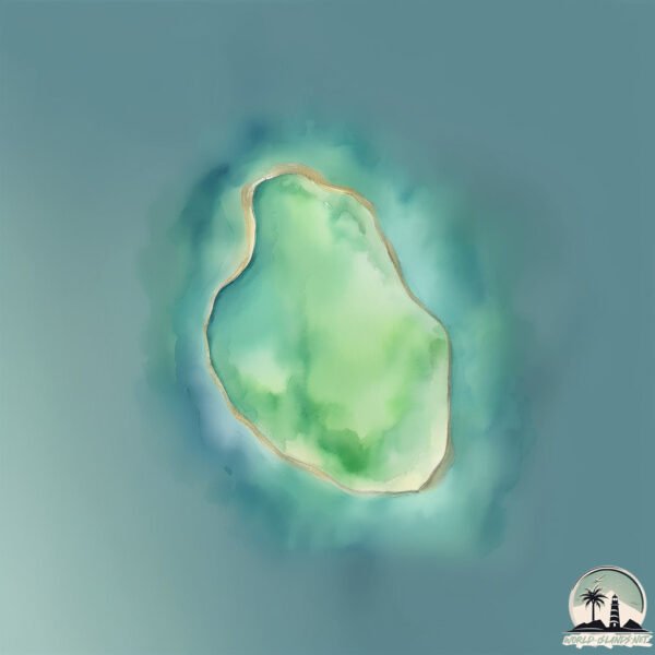
Welcome to Pulau Samut, a Tropical island in the Indian Ocean, part of the majestic Indian Ocean. This guide offers a comprehensive overview of what makes Pulau Samut unique – from its geography and climate to its population, infrastructure, and beyond. Dive into the details:
Geography and size of Pulau Samut
Size: 0.217 km²
Coastline: 1.9 km
Ocean: Indian Ocean
Sea: Indian Ocean
Continent: Asia
Pulau Samut is a Tiny Island spanning 0.217 km² with a coastline of 1.9 km.
Archipel: Malay Archipelago – The world’s largest archipelago, located between mainland Southeast Asia and Australia, known for its immense biodiversity and cultural diversity.
Tectonic Plate: Sunda – Extends across Southeast Asia, encompassing parts of the Sunda Shelf, known for its interaction with the Australian Plate, contributing to volcanic activity in Indonesia.
The geographic heart of the island is pinpointed at these coordinates:
Latitude: 2.13087378 / Longitude: 97.35120192
Climate and weather of Pulau Samut
Climate Zone: Tropical
Climate Details: Tropical Rainforest Climate
Temperature: Hot
Climate Characteristics: This climate is typified by heavy rainfall throughout the year, high humidity, and consistently high temperatures, leading to lush rainforests and rich biodiversity. Seasonal temperature variations are minimal.
Topography and nature of Pulau Samut
Timezone: UTC+07:00
Timezone places: Asia/Jakarta
Max. Elevation: 1 m
Mean Elevation: -4 m
Vegetation: Evergreen Broadleaf Forest
Tree Coverage: 83%
The mean elevation is -4 m. The highest elevation on the island reaches approximately 1 meters above sea level. The island is characterized by Plains: Flat, low-lying lands characterized by a maximum elevation of up to 200 meters. On islands, plains are typically coastal lowlands or central flat areas.
Dominating Vegetation: Evergreen Broadleaf Forest
Characterized by dense, lush canopies of broadleaf trees that retain their leaves year-round. These forests are typically found in tropical and subtropical regions and are known for their high biodiversity. Pulau Samut has a tree cover of 83 %.
Vegetation: 1 vegetation zones – Minimal Diversity Island
These islands exhibit the most basic level of ecological diversity, often characterized by a single dominant vegetation type. This could be due to extreme environmental conditions, limited land area, or significant human impact. They represent unique ecosystems where specific species have adapted to thrive in these singular environments.
Infrastructure and Travelling to Pulau Samut
Does the island have a public airport? no.
There is no public and scheduled airport on Pulau Samut. The nearest airport is Syekh Hamzah Fansyuri Airport, located 70 km away.
Does the island have a major port? no.
There are no major ports on Pulau Samut. The closest major port is SIBOLGA, approximately 163 km away.
The mean population of Pulau Samut is 84 per km². Pulau Samut is Gently Populated. The island belongs to Indonesia.
Continuing your journey, Tuangku is the next notable island, situated merely km away.
🇹🇭 FULL TOUR Koh Samet - Thailand 🏝️ 100% BETTER Than Koh Larn
Full Tour of Koh Samet, Thailand. Discover the island's best beaches, clear waters, top spots and explore. See the best bays and ...🇹🇭 FULL TOUR Koh Samet - Thailand 🏝️ 100% BETTER Than Koh Larn
Full Tour of Koh Samet, Thailand. Discover the island's best beaches, ...
Full Tour of Koh Samet, Thailand. Discover the island's best beaches, clear waters, top spots and explore. See the best bays and ...
We Never Knew KOH SAMET Was Like This! 🏝️ Bangkok’s Nearby Paradise
Check out our most trusted travel luggage by clicking the link (Use ...
Check out our most trusted travel luggage by clicking the link (Use code: "FN10" for 10% off): ...
I Stayed at Thailand's BEST ISLAND 🇹🇭 Luxury vs Budget
Enjoying Paradise in Thaiand ft. Koh Samet - Head to ...
Koh Samet Travel Guide | Must KNOW before you go to KOH SAMET
Looking for the most important things to know before visiting Koh ...
Looking for the most important things to know before visiting Koh Samet? Look no further! In this video, I've noted everything you ...
Koh Samet is Thailand’s HIDDEN GEM You NEED to See!
Is Koh Samet Thailand's Best Hidden Island? *Access our Private ...
Is Koh Samet Thailand's Best Hidden Island? *Access our Private Thailand Map with over 300 Google Maps Locations* ...
🥇 BEST island in Thailand Right Now
Koh Samet is a small, beautiful island not far from Bangkok. It has ...
Koh Samet is a small, beautiful island not far from Bangkok. It has soft sand, clear water, and a fun but relaxed feel. In this video, I ...
Koh Samet, Thailand - Ultimate Island Getaway Near Bangkok
Travel with us in real time and in this video discover Koh Samet, one ...
Travel with us in real time and in this video discover Koh Samet, one of Thailand's most beautiful islands and the perfect tropical ...
I Finally Visited KOH SAMET 🇹🇭 But Is It Really Thailand's BEST Island?
Finally I came to Koh Samet - Thailand - Head to ...
Koh Samet Guide for First Timers (save MONEY & TIME!)
12 Free Thailand Guides, Courses, Lists: ...
koh samet thailand: save money
Koh Samet, located only 2 1/2 hours away from Bangkok via a direct ...
Koh Samet, located only 2 1/2 hours away from Bangkok via a direct highway, is one of the favorite getaway islands for the people ...
Explore Koh Samet's Most Popular Beach - White Sands Beach 🇹🇭 Thailand
White Sands Beach on Koh Samet Island, the longest and most popular ...
White Sands Beach on Koh Samet Island, the longest and most popular Beach on this tropical Island Paradise. Just 2,5 hours ...
koh samet island is rayongs most famous attraction
Remember, this is only a short clip! Watch the full video on my ...
Remember, this is only a short clip! Watch the full video on my channel where I talk about 5 reasons to consider before traveling to ...
Rent Motorbike 🇹🇭 Ko Samet Island Thailand Beaches
Wow! You Won’t Believe What Happens on Koh Samet Island 🇹🇭
Welcome to the beautiful island of Koh Samet! Join me as I explore one ...
Welcome to the beautiful island of Koh Samet! Join me as I explore one of Thailand's most stunning island getaways.
Don't Visit KOH SAMUI Until You've Seen This!
Don't Visit KOH SAMUI Until You've Seen This! Discover the hidden gems ...
Don't Visit KOH SAMUI Until You've Seen This! Discover the hidden gems of Koh Samui while avoiding the notorious tourist traps ...
Clear Ocean in Thailand 🇹🇭 Koh Samet Island
Best Places to visit in Thailand. Must visit Island. #thailand #thailandtravel
Discover the 5 must-visit islands in Thailand that offer crystal-clear ...
Discover the 5 must-visit islands in Thailand that offer crystal-clear waters, stunning beaches, and unforgettable experiences!
This is KOH SAMET 🇹🇭 Thailand's Best Island is right next to Bangkok
Just a few hours from Bangkok lies one of Thailand's best-kept secrets ...
Just a few hours from Bangkok lies one of Thailand's best-kept secrets — Koh Samet (Ko Samet / Ko Samed). This small but ...
Most beautiful beach on the island koh Samet
City Tour 🇹🇭 Ko Samet Island Thailand Beaches
Ever heard about Koh Samet Island in Thailand?
Ever heard about Koh Samet Island in Thailand? Just a 2 1/2 - 3-hour ...
Ever heard about Koh Samet Island in Thailand? Just a 2 1/2 - 3-hour drive from bustling Bangkok. Koh Samet Island is fairly ...
Pattaya to Koh Samet 🇹🇭 Ferry Ride & Island Resort Tour
Pattaya to Koh Samet Ferry Ride & Island Resort Tour Join us on a ...
Pattaya to Koh Samet Ferry Ride & Island Resort Tour Join us on a travel day adventure as we leave busy Pattaya behind ...
Koh Samet This is a MUST Visit Island🇹🇭
10 Years Travelling Thailand and you can still get surprised. We ...
10 Years Travelling Thailand and you can still get surprised. We stayed close to the Gulf of Thailand for Koh Chang and Koh Kood ...
KOH SAMUI, THAILAND | 10 Incredible Things To Do In & Around Koh Samui
Koh Samui is located in the southern Gulf of Thailand. It's the ...
Koh Samui is located in the southern Gulf of Thailand. It's the largest island of the Samui Archipelago and the second-largest in ...
Top 10 Things To Do in Koh Samet
Looking for the best things to do in Koh Samet? Look no further! In ...
Looking for the best things to do in Koh Samet? Look no further! In this video, I've listed the top 10 places to visit in Koh Samet.
Indonesia is classified as Emerging region: MIKT: Mexico, Indonesia, South Korea, and Turkey – Economies recognized for their development potential and emerging market status. The level of income is Lower middle income.
News – Latest Updates and Headlines from Pulau Samut
Stay informed with the most recent news and important headlines from Pulau Samut. Here’s a roundup of the latest developments.
Loading...
Please note: The data used here has been primarily extracted from satellite readings. Deviations from exact values may occur, particularly regarding the height of elevations and population density. Land area and coastline measurements refer to average values at mean high tide.