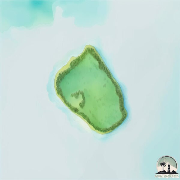
Welcome to Pulau Selatan, a Tropical island in the Banda Sea, part of the majestic Pacific Ocean. This guide offers a comprehensive overview of what makes Pulau Selatan unique – from its geography and climate to its population, infrastructure, and beyond. Dive into the details:
Geography and size of Pulau Selatan
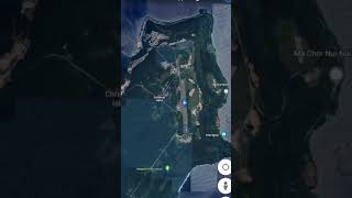
Size: 0.225 km²
Coastline: 1.9 km
Ocean: Pacific Ocean
Sea: Banda Sea
Continent: Oceania
Pulau Selatan is a Tiny Island spanning 0.225 km² with a coastline of 1.9 km.
Archipel: Melanesia – A subregion of Oceania in the southwestern Pacific Ocean, including countries like Fiji, Solomon Islands, and Vanuatu, known for their diverse cultures and languages.
Tectonic Plate: Banda Sea – A small plate in the eastern Indonesian region, known for complex interactions with the Australian and Pacific plates, leading to notable seismic and volcanic activity.
The geographic heart of the island is pinpointed at these coordinates:
Latitude: -5.51004301 / Longitude: 127.55378169
Climate and weather of Pulau Selatan
Climate Zone: Tropical
Climate Details: Tropical Rainforest Climate
Temperature: Hot
Climate Characteristics: This climate is typified by heavy rainfall throughout the year, high humidity, and consistently high temperatures, leading to lush rainforests and rich biodiversity. Seasonal temperature variations are minimal.
Topography and nature of Pulau Selatan
Timezone: UTC+09:00
Timezone places: Asia/Tokyo
Max. Elevation: 3 m
Mean Elevation: 3 m
Vegetation: Evergreen Broadleaf Forest
Tree Coverage: 62%
The mean elevation is 3 m. The highest elevation on the island reaches approximately 3 meters above sea level. The island is characterized by Plains: Flat, low-lying lands characterized by a maximum elevation of up to 200 meters. On islands, plains are typically coastal lowlands or central flat areas.
Dominating Vegetation: Evergreen Broadleaf Forest
Characterized by dense, lush canopies of broadleaf trees that retain their leaves year-round. These forests are typically found in tropical and subtropical regions and are known for their high biodiversity. Pulau Selatan has a tree cover of 62 %.
Vegetation: 1 vegetation zones – Minimal Diversity Island
These islands exhibit the most basic level of ecological diversity, often characterized by a single dominant vegetation type. This could be due to extreme environmental conditions, limited land area, or significant human impact. They represent unique ecosystems where specific species have adapted to thrive in these singular environments.
Infrastructure and Travelling to Pulau Selatan
Does the island have a public airport? no.
There is no public and scheduled airport on Pulau Selatan. The nearest airport is Pattimura International Airport, located 208 km away.
Does the island have a major port? no.
There are no major ports on Pulau Selatan. The closest major port is AMBON, approximately 214 km away.
The mean population of Pulau Selatan is 18 per km². Pulau Selatan is Gently Populated. The island belongs to Indonesia.
Continuing your journey, Pulau Ambelau is the next notable island, situated merely km away.
Pulau Terluar di Selatan Jawa Timur
Terbang dari Jakarta ke Nusa Barong.Pulau Terluar di Selatan Jawa Timur
Terbang dari Jakarta ke Nusa Barong.
Terbang dari Jakarta ke Nusa Barong.
Dimanakah Pulau Paling Selatan Indonesia ? #mentoyo_pedia
Pulau 🏝️ paling selatan Indonesia dengan menggunakan animasi balon ...
Pulau 🏝️ paling selatan Indonesia dengan menggunakan animasi balon udara. untuk pulau yang paling utara adalah....
Wisata Pulau Dutungan #wisata #pejalan #barru
Pulau Dutungan, Destinasi Wisata Keren di Sulsel #wisata #healing #traveling #barru #sulsel
this is not maldives, but WIDI island is in Halmahera Selatan INDONESIA
Widi Island, South Halmahera is Maldives island Indonesia version. ...
Widi Island, South Halmahera is Maldives island Indonesia version. Kepulauan Widi adalah tempat yang sangat Indah, biasa ...
Pesona dan Keindahan Pulau Pagang - Pesisir Selatan, Sudah Pernah Kesini Dunsanak? #sumbar
Kepulauan Selayar: Keajaiban Di Paling Ujung Selatan Sulawesi Yang Belum Seluruhnya Diketahui!
Kepulauan Selayar: Keajaiban Di Paling Ujung Selatan Sulawesi Yang ...
Kepulauan Selayar: Keajaiban Di Paling Ujung Selatan Sulawesi Yang Belum Seluruhnya Diketahui! Kepulauan Selayar, adalah ...
Mengenal Cocos Island, Pulau Selatan Jawa Milik Australia Yang Dihuni Bangsa Melayu
Pulau Cocos, juga dikenal sebagai Pulau Keeling, adalah sebuah atol ...
Pulau Cocos, juga dikenal sebagai Pulau Keeling, adalah sebuah atol tropis yang terletak di Samudera Hindia, sekitar 2.750 km ...
Pulau Ndana, Surga Tersembunyi di Selatan Indonesia
Pulau Ndana mungkin masih jarang terdengar karena lantaran berada di ...
Pulau Ndana mungkin masih jarang terdengar karena lantaran berada di titik terdepan selatan Indonesia. Meski begitu, pulau ...
Pulau Berpenghuni Terpencil di Dunia?
Pulau Berpenghuni Terpencil di Dunia? @mkmthings #pitcairnislands ...
Pulau Berpenghuni Terpencil di Dunia? @mkmthings #pitcairnislands #pitcairn #adamstown #ocean #oceanía #oceania ...
Pulau Misterius di Indonesia #Shorts
Bagaimana Pulau Natuna Membelah Geografi Malaysia
PALING SELATAN‼️ Penuh Perjuangan Ke Pulau Ndana Di Ujung Selatan Indonesia - Kembara Nusa Eps - 23
Perjalanan Touring di NTT Kembara Nusa saya lanjutkan ya, setelah ...
Perjalanan Touring di NTT Kembara Nusa saya lanjutkan ya, setelah mendapatkan informasi tentang pulau Ndana, saya makin ...
PULAU KERAYAAN - KOTABARU - Wisata Kalimantan
Google Map : ========================================== Sosial Media ...
Google Map : ========================================== Sosial Media Lain nya ...
Kenapa China Membangunkan Pulau Spratly Di Laut China Selatan
Join "Membership" APHD Channel dan pilih "Exclusive video" untuk ...
Join "Membership" APHD Channel dan pilih "Exclusive video" untuk mendapatkan akses video eksklusif JOIN NOW ...
PULAU SETAN | Tempat Paling Ikonik Di Kawasan Wisata Mandeh | Kabupaten Pesisir Selatan, Sumbar
Pulau Setan merupakan salah satu pulau yang terdapat di Kawasan Objek ...
Pulau Setan merupakan salah satu pulau yang terdapat di Kawasan Objek Wisata Mandeh Kecamatan Koto XI Tarusan ...
5 fakta Pulau Cocos, pulau terpencil milik Australia yang terletak di selatan Pulau Jawa
5 fakta unik tentang Pulau Cocos, pulau terpencil milik Australia yang ...
5 fakta unik tentang Pulau Cocos, pulau terpencil milik Australia yang terletak di selatan Pulau Jawa, Indonesia.
Eksotis Kepulauan Batu (Rock Island), Nias Selatan
Kepulauan Batu Nias Selatan, Keindahan Nias Selatan, meliputi ...
Kepulauan Batu Nias Selatan, Keindahan Nias Selatan, meliputi pulau-pulau yang termasuk kedalam bentang alamnya.
Pulau Ndana, Pulau Paling Selatan Indonesia
Cocos Island: Daerah Australia Rasa Indonesia
EXPLORENESIA || Pulau Mengkudu ( Mengkudu Island ) , Lampung Selatan
MENGKUDU wisata pulau mengkudu ini mulai populer pada tahun 2015 saat ...
MENGKUDU wisata pulau mengkudu ini mulai populer pada tahun 2015 saat banyak pengunjung yang mengabadikan foto ...
Pulau Laut Natuna ‼️ Pulau Penjaga Kedaulatan Indonesia di Laut Cina Selatan #pulaulaut #natuna
Inilah Pulau Laut, pulau terluar Indonesia yang berada di Kabupaten ...
Inilah Pulau Laut, pulau terluar Indonesia yang berada di Kabupaten Natuna, Provinsi Kepulauan Riau. Pulau ini memiliki luas ...
Keindahan Pelabuhan Tuapejat di Mentawai
Pulau Rote, Pulau Berpenghuni Paling selatan Indonesia dekat Australia #pulaurote #rote #ProvinsiNTT
Inilah Pulau Rote, pulau paling selatan di Indonesia! Terletak di ...
Inilah Pulau Rote, pulau paling selatan di Indonesia! Terletak di Provinsi Nusa Tenggara Timur, pulau ini berada tepat di bawah ...
Di selatan Pulau Jawa, ada pulau kecil memiliki bandara, namun bukan milik Negara Indonesia
Pulau kecil di selatan jawa yang memiliki bandara.
Pulau kecil di selatan jawa yang memiliki bandara.
Indonesia is classified as Emerging region: MIKT: Mexico, Indonesia, South Korea, and Turkey – Economies recognized for their development potential and emerging market status. The level of income is Lower middle income.
News – Latest Updates and Headlines from Pulau Selatan
Stay informed with the most recent news and important headlines from Pulau Selatan. Here’s a roundup of the latest developments.
Loading...
Please note: The data used here has been primarily extracted from satellite readings. Deviations from exact values may occur, particularly regarding the height of elevations and population density. Land area and coastline measurements refer to average values at mean high tide.