Welcome to Pulau Sumadra, a Tropical island in the Java Sea, part of the majestic Pacific Ocean. This guide offers a comprehensive overview of what makes Pulau Sumadra unique – from its geography and climate to its population, infrastructure, and beyond. Dive into the details:
Geography and size of Pulau Sumadra
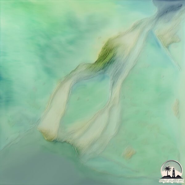
Size: 2.771 km²
Coastline: 9.9 km
Ocean: Pacific Ocean
Sea: Java Sea
Continent: Asia
Pulau Sumadra is a Small Island spanning 2.8 km² with a coastline of 9.9 km.
Archipel: Greater Sunda Islands – A group of large islands in Southeast Asia, including Borneo, Sumatra, Java, and Sulawesi, known for their rich biodiversity and cultural diversity.
Tectonic Plate: Sunda – Extends across Southeast Asia, encompassing parts of the Sunda Shelf, known for its interaction with the Australian Plate, contributing to volcanic activity in Indonesia.
The geographic heart of the island is pinpointed at these coordinates:
Latitude: -2.89715349 / Longitude: 111.42670833
Climate and weather of Pulau Sumadra
Climate Zone: Tropical
Climate Details: Tropical Rainforest Climate
Temperature: Hot
Climate Characteristics: This climate is typified by heavy rainfall throughout the year, high humidity, and consistently high temperatures, leading to lush rainforests and rich biodiversity. Seasonal temperature variations are minimal.
Topography and nature of Pulau Sumadra
Timezone: UTC+07:00
Timezone places: Asia/Jakarta
Max. Elevation: 9 m
Mean Elevation: 8 m
Vegetation: Mangrove Forest
Tree Coverage: 78%
The mean elevation is 8 m. The highest elevation on the island reaches approximately 9 meters above sea level. The island is characterized by Plains: Flat, low-lying lands characterized by a maximum elevation of up to 200 meters. On islands, plains are typically coastal lowlands or central flat areas.
Dominating Vegetation: Mangrove Forest
Found in coastal areas and river deltas, these unique wetland ecosystems are adapted to saline conditions and are crucial for coastal protection and biodiversity. Pulau Sumadra has a tree cover of 78 %.
Vegetation: 4 vegetation zones – Diverse Island
Four distinct vegetation zones mark these islands as ecologically diverse. They might feature varied landscapes such as forests, beaches, grasslands, and rocky areas. Such diversity reflects the island’s complex ecological interactions and varied habitats, which can support a rich array of wildlife and plant species.
Infrastructure and Travelling to Pulau Sumadra
Does the island have a public airport? no.
There is no public and scheduled airport on Pulau Sumadra. The nearest airport is Iskandar Airport, located 33 km away.
Does the island have a major port? no.
There are no major ports on Pulau Sumadra. The closest major port is KUMAI, approximately 34 km away.
The mean population of Pulau Sumadra is 29 per km². Pulau Sumadra is Gently Populated. The island belongs to Indonesia.
Continuing your journey, Pulau Gelam is the next notable island, situated merely km away.
Tropical Paradise a.k.a📍Raja Ampat, Indonesia
The Raja Ampat archipelago straddles the Equator and forms part of Coral Triangle which contains the richest marine biodiversity ...Tropical Paradise a.k.a📍Raja Ampat, Indonesia
The Raja Ampat archipelago straddles the Equator and forms part of ...
The Raja Ampat archipelago straddles the Equator and forms part of Coral Triangle which contains the richest marine biodiversity ...
PULAU WEH: An Ultimate Guide to Indonesia's Hidden Island
Discover Weh Island, the northernmost tip of Sumatra, Indonesia. Enjoy ...
Discover Weh Island, the northernmost tip of Sumatra, Indonesia. Enjoy stunning views, serene holidays, amazing snorkeling, and ...
Pulau kuda sable island #shorts
PULAU MISTERIUS, ADA YANG TAHU NAMANYA? #kepri #indonesia
Pulau Paling Terpencil?
Pulau Paling Terpencil? #mkmthings #tristandacunha #remoteisland.
Pulau Paling Terpencil? #mkmthings #tristandacunha #remoteisland.
Christmas Island, Kehidupan Muslim di Pulau Natal
Christmas Island atau pulau natal, adalah wilayah luar Australia yang ...
Christmas Island atau pulau natal, adalah wilayah luar Australia yang Terletak di Samudra Hindia. Jaraknya sekitar 350 kilometer ...
Pulau Misterius di Indonesia #Shorts
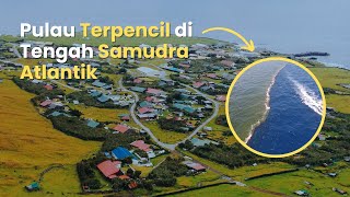
Tristan da Cunha: Pulau Terpencil di Tengah Samudra Atlantik
Jelajahi kehidupan unik di Tristan da Cunha, pulau paling terpencil di ...
Jelajahi kehidupan unik di Tristan da Cunha, pulau paling terpencil di dunia yang terletak di tengah Samudra Atlantik!
Pulau Berpenghuni Terpencil di Dunia?
Pulau Berpenghuni Terpencil di Dunia? @mkmthings #pitcairnislands ...
Pulau Berpenghuni Terpencil di Dunia? @mkmthings #pitcairnislands #pitcairn #adamstown #ocean #oceanía #oceania ...
INCREDIBLE Maldives. Is this REAL? #shorts #maldives Cc: ishotmaldives
Incredible Soneva Jani Resort in Maldives. Cc: ishotmaldives One of ...
Incredible Soneva Jani Resort in Maldives. Cc: ishotmaldives One of the best resorts in Maldives and in the whole world.
5 Best Islands to Visit Near Phuket: Stunning Island Getaways
Discover the 5 best islands to visit near Phuket for a perfect ...
Discover the 5 best islands to visit near Phuket for a perfect getaway! From the stunning Similan Islands to the famous Phi Phi ...
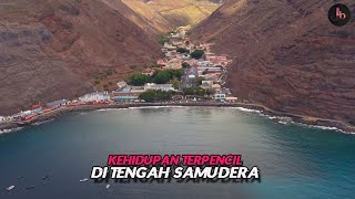
Pulau Terpencil di Tengah Samudera Dihuni Ribuan Manusia
Saint Helena adalah wilayah seberang laut Inggris yang terletak di ...
Saint Helena adalah wilayah seberang laut Inggris yang terletak di Samudera Atlantik Selatan. Wilayah ini merupakan teritorial di ...
Escape to Paradise: Shebara Island 🌊✨
Less than 2 hours from Riyadh and Jeddah, Shebara Island is your ...
Less than 2 hours from Riyadh and Jeddah, Shebara Island is your ultimate winter escape! Dive into the Red Sea's luxury vibes ...
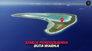
Pulau Terpencil Yang Dihuni Orang Buta Warna
Pingelap atau populer dengan sebutan pulau Mikronesia adalah sebuah ...
Pingelap atau populer dengan sebutan pulau Mikronesia adalah sebuah wilayah yang lokasinya berada di antara Hawaii dan ...
Why Everyone is Talking About Mauritius: The Ultimate Island Paradise!
Mauritius, a breathtaking jewel, is a tropical paradise known for its ...
Mauritius, a breathtaking jewel, is a tropical paradise known for its crystal-clear turquoise waters, pristine white-sand beaches, ...
Koh Phi Phi 🏝️ Krabi , Thailand 🇹🇭 #thailand #travel #vacation #boat #trip #beach #islandlife
Pulau Pandang Batu Bara Sumatera Utara #pulaupandang #disumutaja #wisatasumut #sumut
Beautiful Maldives in the 5* resort Como Cocoa Island 🤩🏝️ #maldives #luxurytravel #bestresorts
Como Cocoa Island is a 5* Luxury Resort in the Maldives with 30 ...
Como Cocoa Island is a 5* Luxury Resort in the Maldives with 30 overwater villas.
Pulau Pasir di Atlantik yang Jadi Rumah Kuda Liar
Pastikan Subscribe untuk tahu berita terupdate di Bogor Hallo Bogor ...
Pastikan Subscribe untuk tahu berita terupdate di Bogor Hallo Bogor mengulas seputar berita Bogor hari ini website ...
Snake Island #brazil #south #america #earth #climatechange #snake #upsc #ias #animation #gigachad
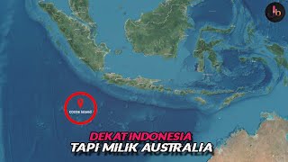
Cocos Island, Pulau Milik Australia Yang Dihuni Orang Keturunan Indonesia
Cocos Keeling Island atau Kepulauan Cocos adalah sebuah pulau ...
Cocos Keeling Island atau Kepulauan Cocos adalah sebuah pulau terpencil di Asia Tenggara yang diatur pemerintahannya oleh ...
Dubai and many artificial islands Palm Jumeirah, Palm Jebel Ali #shorts
ᙖᙓᗩᙀTIᖴᙀᒪ ᙏᙀSIᙅ ᗩᑎᗪ ᐯIᙓᙎ ║* ...
ᙖᙓᗩᙀTIᖴᙀᒪ ᙏᙀSIᙅ ᗩᑎᗪ ᐯIᙓᙎ ║* ...
JANGAN PERNAH BERANI DATANG KE PULAU INI! #shorts #primitive
Suku pedalaman India yg terisolasi dari dunia suku sentinel di ...
Suku pedalaman India yg terisolasi dari dunia suku sentinel di sentinel island #sukupedalaman #terisolasi #primitif #india ...
Andaman and Nicobar Islands map (simplified) #shorts
Berburu & Panen Monster di Pulau Terpencil! 🏝️ Terlihat indah, di balik layar Bibir pecah-pecah 🔥
spearfishing #fishing #catchandcook #camping #beautiful #beach ...
spearfishing #fishing #catchandcook #camping #beautiful #beach #adventure #hunting.
Indonesia is classified as Emerging region: MIKT: Mexico, Indonesia, South Korea, and Turkey – Economies recognized for their development potential and emerging market status. The level of income is Lower middle income.
News – Latest Updates and Headlines from Pulau Sumadra
Stay informed with the most recent news and important headlines from Pulau Sumadra. Here’s a roundup of the latest developments.
Loading...
Please note: The data used here has been primarily extracted from satellite readings. Deviations from exact values may occur, particularly regarding the height of elevations and population density. Land area and coastline measurements refer to average values at mean high tide.