Welcome to Pulau Terbang Selatan, a Tropical island in the Banda Sea, part of the majestic Pacific Ocean. This guide offers a comprehensive overview of what makes Pulau Terbang Selatan unique – from its geography and climate to its population, infrastructure, and beyond. Dive into the details:
Geography and size of Pulau Terbang Selatan
Size: 4.491 km²
Coastline: 11.4 km
Ocean: Pacific Ocean
Sea: Banda Sea
Continent: Oceania
Pulau Terbang Selatan is a Small Island spanning 4.5 km² with a coastline of 11.4 km.
Archipel: Melanesia – A subregion of Oceania in the southwestern Pacific Ocean, including countries like Fiji, Solomon Islands, and Vanuatu, known for their diverse cultures and languages.
Tectonic Plate: Banda Sea – A small plate in the eastern Indonesian region, known for complex interactions with the Australian and Pacific plates, leading to notable seismic and volcanic activity.
The geographic heart of the island is pinpointed at these coordinates:
Latitude: -7.36933598 / Longitude: 128.55864695
Climate and weather of Pulau Terbang Selatan
Climate Zone: Tropical
Climate Details: Tropical Savanna, Wet
Temperature: Hot
Climate Characteristics: Defined by distinct wet and dry seasons with high temperatures year-round. Pronounced rainfall occurs during the wet season, while the dry season is marked by drought.
Topography and nature of Pulau Terbang Selatan
Timezone: UTC+09:00
Timezone places: Asia/Tokyo
Max. Elevation: 67 m
Mean Elevation: 34 m
Vegetation: Evergreen Broadleaf Forest
Tree Coverage: 60%
The mean elevation is 34 m. The highest elevation on the island reaches approximately 67 meters above sea level. The island is characterized by Plains: Flat, low-lying lands characterized by a maximum elevation of up to 200 meters. On islands, plains are typically coastal lowlands or central flat areas.
Dominating Vegetation: Evergreen Broadleaf Forest
Characterized by dense, lush canopies of broadleaf trees that retain their leaves year-round. These forests are typically found in tropical and subtropical regions and are known for their high biodiversity. Pulau Terbang Selatan has a tree cover of 60 %.
Vegetation: 5 vegetation zones – Highly Diverse Island
With five different vegetation zones, these islands offer a rich tapestry of ecosystems. The variety could include dense forests, open meadows, wetlands, coastal zones, and more. This level of diversity supports an intricate web of life, with each zone playing a vital role in the overall ecological health and balance of the island.
Infrastructure and Travelling to Pulau Terbang Selatan
Does the island have a public airport? no.
There is no public and scheduled airport on Pulau Terbang Selatan. The nearest airport is Jos Orno Imsula Airport, located 111 km away.
Does the island have a major port? no.
There are no major ports on Pulau Terbang Selatan. The closest major port is SAUMLAKI, approximately 311 km away.
The mean population of Pulau Terbang Selatan is 18 per km². Pulau Terbang Selatan is Gently Populated. The island belongs to Indonesia.
Continuing your journey, Damar is the next notable island, situated merely km away.
Cocos Island, Pulau Milik Australia Yang Dihuni Orang Keturunan Indonesia
Cocos Keeling Island atau Kepulauan Cocos adalah sebuah pulau terpencil di Asia Tenggara yang diatur pemerintahannya oleh ...Cocos Island, Pulau Milik Australia Yang Dihuni Orang Keturunan Indonesia
Cocos Keeling Island atau Kepulauan Cocos adalah sebuah pulau ...
Cocos Keeling Island atau Kepulauan Cocos adalah sebuah pulau terpencil di Asia Tenggara yang diatur pemerintahannya oleh ...
PULAU NATAL - Dekat Indonesia milik Australia dihuni melayu Malaysia
Teritori Pulau Natal adalah wilayah eksternal Australia di Samudra ...
Teritori Pulau Natal adalah wilayah eksternal Australia di Samudra Hindia yang terdiri dari pulau dengan nama yang sama. Pulau ...
Bissagos Islands, on the Mysterious Islands of West Africa
We invite you to discover the Bissagos Islands, an isolated territory ...
We invite you to discover the Bissagos Islands, an isolated territory of Guinee Bissau, in West Africa. These sacred lands resemble ...
KISAH NYATA TAHUN 1944 TERDAMPAR BERSAMA SUSTER DI PULAU KOSONG SAMUDERA PASIFIK
Heaven Knows Mr. Allison tahun 1957. Mengisahkan seorang pria yang ...
Heaven Knows Mr. Allison tahun 1957. Mengisahkan seorang pria yang terdampar di sebuah pulau terpencil. Dan di pulau itu dia ...
Satu daratan yang kini terbagi dua? inilah Pulau Tasmania
asmania adalah sebuah negara bagian Australia dan pulau dengan nama ...
asmania adalah sebuah negara bagian Australia dan pulau dengan nama yang sama. Beribu kota di Hobart, negara bagian ini ...
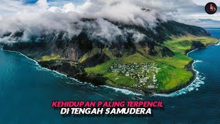
Kehidupan Paling Terpencil di Dunia Yang Berada di Tengah Samudera
Tristan de Cunha atau sering disebut dengan singkatan TDC ini ...
Tristan de Cunha atau sering disebut dengan singkatan TDC ini berlokasi di bagian selatan samudera Atlantik dengan ibu kota ...
Арктика: Мир Вечной Мерзлоты | Интересные факты про Арктику
природа #животные #растения #география #планетаземля Приветствую, Вы ...
природа #животные #растения #география #планетаземля Приветствую, Вы на канале "Планета Земля". Здесь мы будем ...
Apa itu yang tersembunyi di Pulau Sentinel Utara yang terlarang?
Apa itu yang tersembunyi di Pulau Sentinel Utara yang terlarang?
Apa itu yang tersembunyi di Pulau Sentinel Utara yang terlarang?
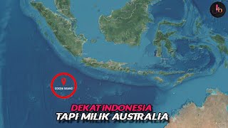
Dekat Dengan Indonesia tapi milik Australia, Inilah Pulau Natal
Apa yang kalian ketahui tentang pulau natal? Pada video kali ini kita ...
Apa yang kalian ketahui tentang pulau natal? Pada video kali ini kita akan membahas pulau yang letaknya tidak terlalu jauh dari ...
Rise of the Jurassic | SCIENCE FICTION | Full Movie in English
A young scientist and her team arrive at a mysterious island, looking ...
A young scientist and her team arrive at a mysterious island, looking for answers as to what happened to her father who ...
BISA TERTIPU KALO GAK TELITI! Ternyata Negara ini Mirip Dengan Indonesia, Bahkan Ada Kecocokan DNA
Sudah jadi hal yang lumrah jika warna bendera Indonesia memiliki ...
Sudah jadi hal yang lumrah jika warna bendera Indonesia memiliki kemiripan dengan beberapa negara lainnya. Tapi apa jadinya ...
開箱台北沖繩新航線✈️沖繩・宮古島一次攻略!不會潛水也能近距離看海龜🤩|沖繩景點・沖繩美食・沖繩必吃・沖繩自由行・吉田社長 Japan TV
日航旗下「JTA日本越洋航空」全新航線即將開航✈️ 台北(桃園)飛往沖繩(那霸)又多一個航班的好選擇啦!機上服務超好, ...
日航旗下「JTA日本越洋航空」全新航線即將開航✈️ 台北(桃園)飛往沖繩(那霸)又多一個航班的好選擇啦!機上服務超好, ...
Malaysia Fishing Trip
Fishing in Malaysia” is extraordinarily diverse and incredibly ...
Fishing in Malaysia” is extraordinarily diverse and incredibly unusual. In a voyage of discovery throughout the Malay Peninsula ...
Verdict! Iwo Jima: Hell on Earth | Wargame | Boardgame | Solo | WW2 | Review
The verdict is in! This is an overview and review of the solitaire war ...
The verdict is in! This is an overview and review of the solitaire war board game Iwo Jima: Hell on Earth. Designed by Jose ...
Philippines Develop Military Bases in Most Strategic Island in West PH Sea CLAIMED by China
viral #china #history #geopolitics In the South China Sea, power is ...
viral #china #history #geopolitics In the South China Sea, power is not always announced with gunfire. Sometimes it arrives ...
🔥【New】【Multi Sub】Job Change: BOSS Legion EP1-82#anime #animation
anime #animation #donghua #動漫#二次元#new anime If you want to watch ...
anime #animation #donghua #動漫#二次元#new anime If you want to watch exciting, exciting and passionate anime, come to ...
Pemandangan Diatas Awan Dari Pesawat Garuda Menuju Makassar, Intip Pulau Kecil Ditengah Lautan
Japan’s New Mach 7 Missile Is a Terrifying Superweapon
For decades, Japan relied on a shield. A powerful one—but a shield ...
For decades, Japan relied on a shield. A powerful one—but a shield nonetheless. Its postwar constitution defined a strictly ...
【Full】【Multi Sub】Receiving billions as a disciple EP 1-130 #animation
anime #animation #donghua #動漫#二次元#new anime Bai Yu came to the fantasy ...
anime #animation #donghua #動漫#二次元#new anime Bai Yu came to the fantasy world and became the head of the Baiyu Sect, ...
Terbang view keren Surabaya - Bali, deretan gunung, lautan awan rapat & latar sunset. Citilink sore
Terbang view keren Surabaya - Bali, deretan gunung, lautan awan rapat ...
Terbang view keren Surabaya - Bali, deretan gunung, lautan awan rapat & latar sunset. Citilink sore. Ini adalah vlog review ...
🌠【斗破苍穹】BTTH Episode 100-180 Full丨超长合集,一口气看过瘾!
每日更新精彩内容,歡迎訂閲!喜歡我分享的動漫請點點訂閱 和贊 支持我哦~ #一号新番社#国漫#动漫解说#cartoon #anime ...
每日更新精彩内容,歡迎訂閲!喜歡我分享的動漫請點點訂閱 和贊 支持我哦~ #一号新番社#国漫#动漫解说#cartoon #anime ...
【FULL】《網遊現實融合:戰神天團聽我調遣》網遊降臨現實!普通玩家意外收徒,座下竟全是天庭戰神!托塔天王、二郎神聽候調遣,打怪如同砍瓜切菜,副本BOSS不堪一擊,他率戰神天團稱霸全服! #逆襲#漫畫
劇情簡介:網遊世界突然降臨現實,林辰還是那個不起眼的普通玩家。一次收徒,他直接解鎖逆天驚喜—— 座下徒弟全是天庭戰神!
劇情簡介:網遊世界突然降臨現實,林辰還是那個不起眼的普通玩家。一次收徒,他直接解鎖逆天驚喜—— 座下徒弟全是天庭戰神!
【Multi SUB】神召:我能召喚滿級BOSS Divine Summoning: I Can Summon a Max-Level Boss EP1-83 #動態漫畫 #anime #男频
00:00 ...
00:00 加入Qixiang-YouTube会员抢先看更多精彩动漫:https://www.youtube.com/channel/UCJSAZ5pbDi8StbSbJI1riEg/join ...
🇳🇿不是第一次來,卻第一次好好旅行|第一站奧克蘭|南半球的夏天|紐西蘭跨年旅行#1
本影片是2025年年底至2026年年初在紐西蘭旅行期間拍攝的影片。 拍攝設備主要是SONY FX30。 ———————————— 如果 ...
本影片是2025年年底至2026年年初在紐西蘭旅行期間拍攝的影片。 拍攝設備主要是SONY FX30。 ———————————— 如果 ...
Is China About To Invade Taiwan?
China's military buildup has put its adversaries on edge while Beijing ...
China's military buildup has put its adversaries on edge while Beijing has fixed its eyes on Taiwan. But what's going on here?
Indonesia is classified as Emerging region: MIKT: Mexico, Indonesia, South Korea, and Turkey – Economies recognized for their development potential and emerging market status. The level of income is Lower middle income.
News – Latest Updates and Headlines from Pulau Terbang Selatan
Stay informed with the most recent news and important headlines from Pulau Terbang Selatan. Here’s a roundup of the latest developments.
Loading...
Please note: The data used here has been primarily extracted from satellite readings. Deviations from exact values may occur, particularly regarding the height of elevations and population density. Land area and coastline measurements refer to average values at mean high tide.