Pulau Teun
Welcome to Pulau Teun, a Tropical island in the Banda Sea, part of the majestic Pacific Ocean. This guide offers a comprehensive overview of what makes Pulau Teun unique – from its geography and climate to its population, infrastructure, and beyond. Dive into the details:
- Geography and Size: Explore the island’s size and location.
- Climate and Weather: Weather patterns and temperature.
- Topography and Nature: Uncover the natural wonders of the island.
- Infrastructure and Travelling: Insights on reaching, staying, and making the most of your visit.
- News and Headlines: Latest News.
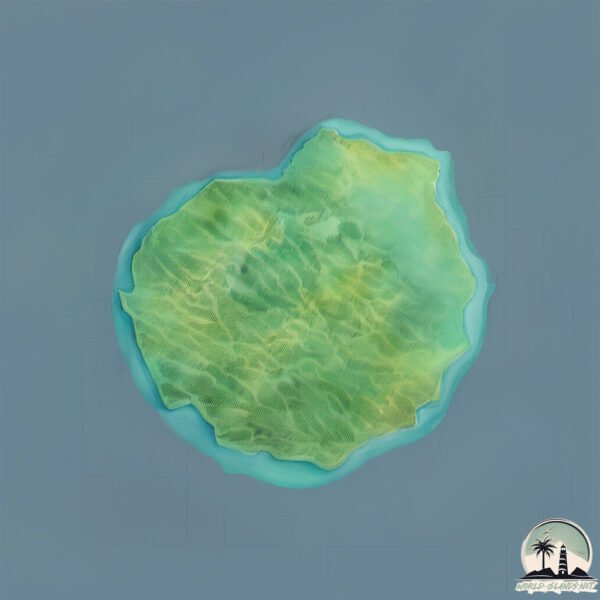
Geography and size of Pulau Teun
Size: 13.9 km²
Coastline: 15.8 km
Ocean: Pacific Ocean
Sea: Banda Sea
Continent: Oceania
Pulau Teun is a Medium Island spanning 14 km² with a coastline of 16 km.
Archipel: Melanesia – A subregion of Oceania in the southwestern Pacific Ocean, including countries like Fiji, Solomon Islands, and Vanuatu, known for their diverse cultures and languages.
Tectonic Plate: Australia – A major tectonic plate covering Australia, New Zealand, and parts of the Indian and Pacific Oceans, known for its relative stability and occasional seismic activity.
The geographic heart of the island is pinpointed at these coordinates:
Latitude: -6.97110726 / Longitude: 129.14336443
Climate and weather of Pulau Teun
Climate Zone: Tropical
Climate Details: Tropical Monsoon Climate
Temperature: Hot
Climate Characteristics: Characterized by heavy rainfall, high humidity, and uniformly high temperatures, but with a distinct short dry season. It features a seasonal reversal of prevailing wind directions.
Topography and nature of Pulau Teun
Timezone: UTC+09:00
Timezone places: Asia/Tokyo
Max. Elevation: 534 m
Mean Elevation: 271 m
Vegetation: Deciduous Broadleaf Forest
Tree Coverage: 54%
The mean elevation is 271 m. The highest elevation on the island reaches approximately 534 meters above sea level. The island is characterized by Plateau: Elevated flatlands rising sharply above the surrounding area, with a maximum elevation over 500 meters but a mean elevation less than 300 meters, forming unique highland areas on islands.
Dominating Vegetation: Deciduous Broadleaf Forest
Composed of broadleaf trees that shed their leaves seasonally. These forests are commonly found in temperate zones and experience distinct seasonal changes. Pulau Teun has a tree cover of 54 %.
Vegetation: 9 vegetation zones – Very Highly Diverse Island
Islands in this range are ecological powerhouses, showcasing a wide array of vegetation zones. Each zone, from lush rainforests to arid scrublands, coastal mangroves to mountainous regions, contributes to a complex and interdependent ecosystem. These islands are often hotspots of biodiversity, supporting numerous species and intricate ecological processes.
Infrastructure and Travelling to Pulau Teun
Does the island have a public airport? no.
There is no public and scheduled airport on Pulau Teun. The nearest airport is Jos Orno Imsula Airport, located 187 km away.
Does the island have a major port? no.
There are no major ports on Pulau Teun. The closest major port is SAUMLAKI, approximately 263 km away.
The mean population of Pulau Teun is 18 per km². Pulau Teun is Gently Populated. The island belongs to Indonesia.
Continuing your journey, Pulau Nila is the next notable island, situated merely km away.
Aerial video of Teun island, Maluku, Indonesia


Indonesia is classified as Emerging region: MIKT: Mexico, Indonesia, South Korea, and Turkey – Economies recognized for their development potential and emerging market status. The level of income is Lower middle income.
News – Latest Updates and Headlines from Pulau Teun
Stay informed with the most recent news and important headlines from Pulau Teun. Here’s a roundup of the latest developments.
- Feed has no items.
Please note: The data used here has been primarily extracted from satellite readings. Deviations from exact values may occur, particularly regarding the height of elevations and population density. Land area and coastline measurements refer to average values at mean high tide.