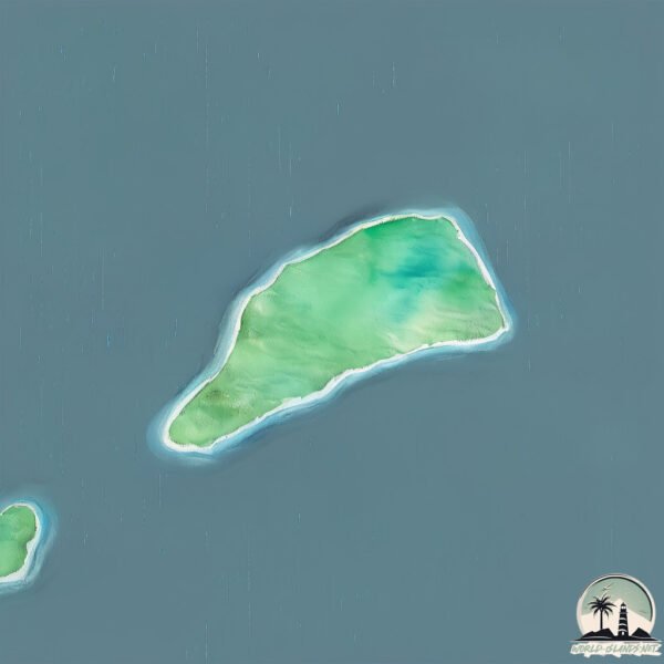
Welcome to Pulau Yar, a Tropical island in the Halmahera Sea, part of the majestic Pacific Ocean. This guide offers a comprehensive overview of what makes Pulau Yar unique – from its geography and climate to its population, infrastructure, and beyond. Dive into the details:
Geography and size of Pulau Yar
Size: 4.161 km²
Coastline: 9.3 km
Ocean: Pacific Ocean
Sea: Halmahera Sea
Continent: Oceania
Pulau Yar is a Small Island spanning 4.2 km² with a coastline of 9.3 km.
Archipel: Melanesia – A subregion of Oceania in the southwestern Pacific Ocean, including countries like Fiji, Solomon Islands, and Vanuatu, known for their diverse cultures and languages.
Tectonic Plate: Sunda – Extends across Southeast Asia, encompassing parts of the Sunda Shelf, known for its interaction with the Australian Plate, contributing to volcanic activity in Indonesia.
The geographic heart of the island is pinpointed at these coordinates:
Latitude: -0.7370026 / Longitude: 130.14163594
Climate and weather of Pulau Yar
Climate Zone: Tropical
Climate Details: Tropical Rainforest Climate
Temperature: Hot
Climate Characteristics: This climate is typified by heavy rainfall throughout the year, high humidity, and consistently high temperatures, leading to lush rainforests and rich biodiversity. Seasonal temperature variations are minimal.
Topography and nature of Pulau Yar
Timezone: UTC+09:00
Timezone places: Asia/Tokyo
Max. Elevation: 34 m
Mean Elevation: 12 m
Vegetation: Evergreen Broadleaf Forest
Tree Coverage: 74%
The mean elevation is 12 m. The highest elevation on the island reaches approximately 34 meters above sea level. The island is characterized by Plains: Flat, low-lying lands characterized by a maximum elevation of up to 200 meters. On islands, plains are typically coastal lowlands or central flat areas.
Dominating Vegetation: Evergreen Broadleaf Forest
Characterized by dense, lush canopies of broadleaf trees that retain their leaves year-round. These forests are typically found in tropical and subtropical regions and are known for their high biodiversity. Pulau Yar has a tree cover of 74 %.
Vegetation: 4 vegetation zones – Diverse Island
Four distinct vegetation zones mark these islands as ecologically diverse. They might feature varied landscapes such as forests, beaches, grasslands, and rocky areas. Such diversity reflects the island’s complex ecological interactions and varied habitats, which can support a rich array of wildlife and plant species.
Infrastructure and Travelling to Pulau Yar
Does the island have a public airport? no.
There is no public and scheduled airport on Pulau Yar. The nearest airport is Marinda Airport, located 77 km away.
Does the island have a major port? no.
There are no major ports on Pulau Yar. The closest major port is SAILOLOF, approximately 87 km away.
The mean population of Pulau Yar is 8 per km². Pulau Yar is Gently Populated. The island belongs to Indonesia.
Continuing your journey, Pulau Gag is the next notable island, situated merely km away.
Meri Yule Island_Tasik_Yard_(Jaytee ft.Initial Jay) 2023 PNG Music - Unofficial Video.
This Music video is an unofficial video created purposely for entertainment. Official Music is produced & sang by Tasik Yard band.Meri Yule Island_Tasik_Yard_(Jaytee ft.Initial Jay) 2023 PNG Music - Unofficial Video.
This Music video is an unofficial video created purposely for ...
This Music video is an unofficial video created purposely for entertainment. Official Music is produced & sang by Tasik Yard band.
kaho na pyaar hai at Poda island krabhi🔥💜✨#Thailand #Best of Memories #A Trip to Cherish #GS love
Hawaii's Forbidden Island 🚷 Tourists Banned on Niʻihau 🏝️
The forbidden mysteries of Niʻihau, the elusive Hawaiian island that ...
The forbidden mysteries of Niʻihau, the elusive Hawaiian island that has been off-limits to humans for over a century. Hawaii's ...
We Found SQUID GAME in Google Earth 🌎 😱😱😱
Like Share Subscribe ❤️ Thanks for Watching !!! #squidgame ...
Like Share Subscribe ❤️ Thanks for Watching !!! #squidgame #squidgamesoundtrack #googleearth.
Snake Island (Full Documentary)
The highest concentration of one of the most venomous snakes in the ...
The highest concentration of one of the most venomous snakes in the world is located about 90 miles off the coast of Santos, ...
Is This The Biggest Snake On Snake Island ⁉️ #snake
Temple of Massa al Dajjal| Dajjal in Guffa| Dajjal Cave | Dajal | Astola Island
Created by @MuhammadAdnan3115 #Dajjal #Islamic #History.
Created by @MuhammadAdnan3115 #Dajjal #Islamic #History.
Andaman and Nicobar Islands map (simplified) #shorts
#Dubai Palm Jumeirah Aerial View
Did you see the @burjalarab? ✈️ Take the window seat when flying to ...
Did you see the @burjalarab? ✈️ Take the window seat when flying to Dubai for a breathtaking aerial view of the iconic Palm ...
Snake Island Brazil #shorts #viralvideo
shorts #factshorts.
shorts #factshorts.
Best Beach in the World | Maya Bay | Thailand Travel Vlog | Phi Phi Island
Best Beach in the World | Maya Bay | Thailand Travel Vlog | Phi Phi ...
Best Beach in the World | Maya Bay | Thailand Travel Vlog | Phi Phi Island This stunning location is Maya Bay which is a ...
Yemen, Mystery of Socotra Island, the Lost World, Dajjal Island in Yemen
Mystery of Socotra, the Lost World, Dajjal Island in Yemen.... In the ...
Mystery of Socotra, the Lost World, Dajjal Island in Yemen.... In the small Island of the Indian Ocean, there is a mysterious island ...
To Andaman and nicobar islands 😊😊
This Village Is Hanging on a Volcanic Mountain
It's hard to believe people built a village in mountains like this. ...
It's hard to believe people built a village in mountains like this. Hidden deep in the rugged mountains of Tenerife, Masca sits ...
lewat muara Tembalang - 9 pulau kerikil
Leaving sa DAS ISLAND OIL FIELD
Squid game island is real! I found on google maps and google earth #map #earth
Squid game island is real! I found on google maps and google earth ...
Squid game island is real! I found on google maps and google earth #map #earth @found.googleEarth @earthjourney2m ...
#shorts Tsunami Caught On Camera🔥#viral#Shorts monetization
shorts Tsunami Caught on Camera #youtubeshorts #viral #ytshorts short ...
shorts Tsunami Caught on Camera #youtubeshorts #viral #ytshorts short youtube shorts monetization@Persblogger Panipuri ...
Yas island , Radisson Blue Abu Dhabi
The excitement of going to a new place I've never been to before makes ...
The excitement of going to a new place I've never been to before makes me do ridiculous things Produced by Shenaz Treasury ...
Most Beautiful Islands of India: Lakshadweep | Agatti, Bangaram and Kavaratti Island
Lakshadweep is home to India's most beautiful islands, and I will ...
Lakshadweep is home to India's most beautiful islands, and I will explore these unexplored Islands of India like Agatti Island, ...
Maldives 🇲🇻 : Male city ✈️🌊😍#maldives #maldivesresorts #trending #shorts #tiktok
The Maldives, officially the Republic of Maldives, is an archipelagic ...
The Maldives, officially the Republic of Maldives, is an archipelagic state and country in South Asia, situated in the Indian Ocean.
Malaysia Muslim Country full Location Maps🇲🇾 #short #malaysia #muslim #maps #islam #viral #location
Malaysia Muslim Country full Location Maps #short #malaysia #muslim ...
Malaysia Muslim Country full Location Maps #short #malaysia #muslim #maps #islam #viral #location Entertainment ...
Pesan Rosyati Mak Pulau ⁉️ Sejarah nama Pulau Tikus ‼️
Rosyati nama asli beliau. 2 tahun setelah menjadi penganten beliau di ...
Rosyati nama asli beliau. 2 tahun setelah menjadi penganten beliau di boyong ke Pulau Tikus sama sekarang. Dengarkan suara ...
Bagaimana Pulau Sekecil ini Bisa Memiliki Populasi Lebih Banyak dari Rusia?
Selamat datang di kanal kami! Dalam video ini, kami akan membahas ...
Selamat datang di kanal kami! Dalam video ini, kami akan membahas Pulau Jawa, salah satu pulau terpadat di dunia yang ...
Indonesia is classified as Emerging region: MIKT: Mexico, Indonesia, South Korea, and Turkey – Economies recognized for their development potential and emerging market status. The level of income is Lower middle income.
News – Latest Updates and Headlines from Pulau Yar
Stay informed with the most recent news and important headlines from Pulau Yar. Here’s a roundup of the latest developments.
Loading...
Please note: The data used here has been primarily extracted from satellite readings. Deviations from exact values may occur, particularly regarding the height of elevations and population density. Land area and coastline measurements refer to average values at mean high tide.