Welcome to Rabbit, a Temperate island in the North Atlantic Ocean, part of the majestic Atlantic Ocean. This guide offers a comprehensive overview of what makes Rabbit unique – from its geography and climate to its population, infrastructure, and beyond. Dive into the details:
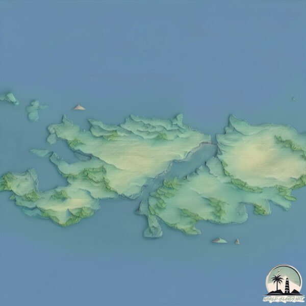
Geography and size of Rabbit
Size: 1.435 km²
Coastline: 17.1 km
Ocean: Atlantic Ocean
Sea: North Atlantic Ocean
Continent: Europe
Rabbit is a Small Island spanning 1.4 km² with a coastline of 17.1 km.
Archipel: British Isles – A group of islands off the northwest coast of mainland Europe, including Great Britain, Ireland, and over 6,000 smaller islands, known for their rich history and cultural diversity.
Tectonic Plate: Eurasia – One of the world’s largest tectonic plates, the Eurasian Plate covers a significant portion of Europe and Asia. It’s characterized by diverse geological features, including the Ural Mountains, the European Plain, and the Himalayas formed from its collision with the Indian Plate.
The geographic heart of the island is pinpointed at these coordinates:
Latitude: 53.84357468 / Longitude: -9.66318174
Climate and weather of Rabbit
Climate Zone: Temperate
Climate Details: Temperate Oceanic Climate
Temperature: Warm Summer
Climate Characteristics: Known for its moderate year-round temperatures with ample rainfall and no dry season. Warm summers are characteristic.
Topography and nature of Rabbit
Timezone: UTC±00:00
Timezone places: Europe/London
Max. Elevation: 7 m
Mean Elevation: 5 m
Vegetation: Open Woodland
Tree Coverage: 75%
The mean elevation is 5 m. The highest elevation on the island reaches approximately 7 meters above sea level. The island is characterized by Plains: Flat, low-lying lands characterized by a maximum elevation of up to 200 meters. On islands, plains are typically coastal lowlands or central flat areas.
Dominating Vegetation: Open Woodland
Characterized by sparsely distributed trees with open canopy allowing sunlight to penetrate, supporting grasses and shrubs underneath. Often found in drier or transitional environments. Rabbit has a tree cover of 75 %.
Vegetation: 4 vegetation zones – Diverse Island
Four distinct vegetation zones mark these islands as ecologically diverse. They might feature varied landscapes such as forests, beaches, grasslands, and rocky areas. Such diversity reflects the island’s complex ecological interactions and varied habitats, which can support a rich array of wildlife and plant species.
Infrastructure and Travelling to Rabbit
Does the island have a public airport? no.
There is no public and scheduled airport on Rabbit. The nearest airport is Connemara Regional Airport, located 71 km away.
Does the island have a major port? no.
There are no major ports on Rabbit. The closest major port is WESTPORT, approximately 13 km away.
The mean population of Rabbit is 30 per km². Rabbit is Gently Populated. The island belongs to Ireland.
Continuing your journey, Inishbofin is the next notable island, situated merely km away.
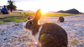
The Mystery of Rabbit Island
Imagine an island filled only with rabbits. Okunoshima is a small island in Japan's Inland Sea. It's called "Rabbit Island" because ...The Mystery of Rabbit Island
Imagine an island filled only with rabbits. Okunoshima is a small ...
Imagine an island filled only with rabbits. Okunoshima is a small island in Japan's Inland Sea. It's called "Rabbit Island" because ...
Rabbits On Okunoshima Island Swarm Tourist
A whopping 600 rabbits! Trip to Japan's Amazing Rabbit Island🐰
Please experience a travel to Japan! I visited Rabbit Island, which is ...
Please experience a travel to Japan! I visited Rabbit Island, which is full of rabbits. A cute and friendly bunny. The hotel's ...
Exclusive Tour of Rabbit Island Japan by a Bunny Expert
Shai took a trip to Ōkunoshima, Japan, otherwise known as The Rabbit ...
Shai took a trip to Ōkunoshima, Japan, otherwise known as The Rabbit Island. You won't believe how many rabbits he met there.
Why Is This Island Filled With Rabbits?
Imagine an island filled only with rabbits. Okunoshima is a small ...
Imagine an island filled only with rabbits. Okunoshima is a small island in Japan's Inland Sea. It's called "Rabbit Island" because ...
Freddie Gibbs - Rabbit Island (Official Visualizer)
Rabbit: “May I get on your lap?”
"Okunoshima" in Takehara City, Hiroshima Prefecture, Japan. This ...
"Okunoshima" in Takehara City, Hiroshima Prefecture, Japan. This island in the Seto Inland Sea is home to over 900 rabbits, and ...
See Why They Call It "Rabbit Island" | Nat Geo Wild
The small island of Ōkunoshima in Japan has become famous for a large ...
The small island of Ōkunoshima in Japan has become famous for a large and growing population of non-native rabbits.
The moment I petted the rabbit, it demanded more!
"Okunoshima" in Takehara City, Hiroshima Prefecture, Japan. This ...
"Okunoshima" in Takehara City, Hiroshima Prefecture, Japan. This island in the Seto Inland Sea is home to over 900 rabbits, and ...
Kawaii!The Only RABBIT ISLAND in the World - Uninhabited with 700 Wild Rabbits | Japanese Island
What is Ohkunojima? An uninhabited island belonging to Takehara City, ...
What is Ohkunojima? An uninhabited island belonging to Takehara City, Hiroshima Prefecture It takes about 15 minutes by boat ...
Rabbit Island in Japan 🇯🇵🏝🐰
The Only Bunny Island in the World 🏝️🐇 Visiting Japan’s Rabbit Paradise ✨
I visited Ōkunoshima in Hiroshima Prefecture. Ōkunoshima is the only ...
I visited Ōkunoshima in Hiroshima Prefecture. Ōkunoshima is the only island in the world where wild rabbits live. I was able to ...
BUNNY ISLAND : The fluffiest paradise in the world. 🐇
BUNNY ISLAND : The fluffiest paradise in the world. Bunny Island ...
BUNNY ISLAND : The fluffiest paradise in the world. Bunny Island actually exists! Sounds like a dream! Right? But it really ...
Rabbit: "What the heck is that sound?"
"Okunoshima" in Takehara City, Hiroshima Prefecture, Japan. This ...
"Okunoshima" in Takehara City, Hiroshima Prefecture, Japan. This island in the Seto Inland Sea is home to over 900 rabbits, and ...
Why is this island chock full of rabbits? 🐇🐇🐇 - BBC
The Dark, Twisted Truth About Rabbit Island Japan
Follow me on my journey to rabbit island, also known as Okunoshima in ...
Follow me on my journey to rabbit island, also known as Okunoshima in Japan. Here, I discover that not everything is as cute as it ...
Kerem Gell - Rabbit Island
Japan's RABBIT ISLAND - Incredible!
In this Rabbit Island pilot video, we visit Ōkunoshima (大久野島), a small ...
In this Rabbit Island pilot video, we visit Ōkunoshima (大久野島), a small island located in the Inland Sea of Japan in the city of ...
I petted the rabbit and it melted.
"Okunoshima" in Takehara City, Hiroshima Prefecture, Japan. This ...
"Okunoshima" in Takehara City, Hiroshima Prefecture, Japan. This island in the Seto Inland Sea is home to over 900 rabbits, and ...
[Rabbit Island, JAPAN] 600 rabbits live on Rabbit Island travel🐰🥕 Cute rabbit paradise! | 大久野島 うさぎ島
We visited “Rabbit Island,” the only rabbit paradise in the world. ...
We visited “Rabbit Island,” the only rabbit paradise in the world. (Okunoshima / Tadanoumi-cho, Takehara City, Hiroshima ...
Exploring Japan's Adorable Rabbit Island 🐰🌴 | Ōkunoshima
Inside Japan's Rabbit Island 🐰
I visited Japan's famous Rabbit Island, also known as Okunoshima, ...
I visited Japan's famous Rabbit Island, also known as Okunoshima, where hundreds of wild rabbits roam freely across the island.
[Rabbit Island, JAPAN] Cute baby rabbits in paradise🐰 Island of 600 wild bunnies🐇 | Okunoshima 大久野島
We visited the world's only rabbit paradise, "Rabbit Island" ...
We visited the world's only rabbit paradise, "Rabbit Island" (Okunoshima - Tadanoumi-cho, Takehara City, Hiroshima Prefecture).
History behind "Rabbit Island"
History behind "Rabbit Island"
History behind "Rabbit Island"
I petted a baby rabbit's butt and it melted.
"Okunoshima" in Takehara City, Hiroshima Prefecture, Japan. This ...
"Okunoshima" in Takehara City, Hiroshima Prefecture, Japan. This island in the Seto Inland Sea is home to over 900 rabbits, and ...
Ireland is classified as Developed region: nonG7: Developed economies outside of the Group of Seven, characterized by high income and advanced economic structures. The level of income is High income: OECD.
News – Latest Updates and Headlines from Rabbit
Stay informed with the most recent news and important headlines from Rabbit. Here’s a roundup of the latest developments.
Loading...
Please note: The data used here has been primarily extracted from satellite readings. Deviations from exact values may occur, particularly regarding the height of elevations and population density. Land area and coastline measurements refer to average values at mean high tide.


![[Rabbit Island, JAPAN] 600 rabbits live on Rabbit Island travel🐰🥕 Cute rabbit paradise! | 大久野島 うさぎ島](https://i.ytimg.com/vi/6Z_-j-qb7XM/mqdefault.jpg)


![[Rabbit Island, JAPAN] Cute baby rabbits in paradise🐰 Island of 600 wild bunnies🐇 | Okunoshima 大久野島](https://i.ytimg.com/vi/mQDmkgDE1_c/mqdefault.jpg)

