Welcome to Rabida, a Tropical island in the South Pacific Ocean, part of the majestic Pacific Ocean. This guide offers a comprehensive overview of what makes Rabida unique – from its geography and climate to its population, infrastructure, and beyond. Dive into the details:
Geography and size of Rabida
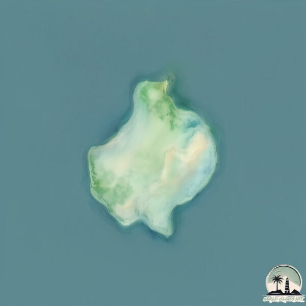
Size: 5.11 km²
Coastline: 10.5 km
Ocean: Pacific Ocean
Sea: South Pacific Ocean
Continent: South America
Rabida is a Small Island spanning 5.1 km² with a coastline of 10.5 km.
Archipel: Galapagos Islands – An Ecuadorian archipelago in the Pacific Ocean, famous for their unique wildlife and as a key location for evolutionary studies.
Tectonic Plate: North Andes – Located in South America, covering Colombia, Ecuador, and part of Venezuela, it is known for its seismic activity due to interactions with the South American Plate.
The geographic heart of the island is pinpointed at these coordinates:
Latitude: -0.41376581 / Longitude: -90.70860929
Climate and weather of Rabida
Climate Zone: Tropical
Climate Details: Tropical Savanna, Wet
Temperature: Hot
Climate Characteristics: Defined by distinct wet and dry seasons with high temperatures year-round. Pronounced rainfall occurs during the wet season, while the dry season is marked by drought.
Topography and nature of Rabida
Timezone: UTC-06:00
Timezone places: America/Chicago
Max. Elevation: 217 m
Mean Elevation: 143 m
Vegetation: Shrubland
Tree Coverage: 58%
The mean elevation is 143 m. The highest elevation on the island reaches approximately 217 meters above sea level. The island is characterized by Hills: Gently sloping landforms with rounded tops, having a maximum elevation between 200 and 500 meters. Hills contribute to a varied landscape on islands.
Dominating Vegetation: Shrubland
Dominated by shrubs and small bushes, these areas are typical in dry, rocky, or sandy environments, as well as in regions with poor soil fertility. Rabida has a tree cover of 58 %.
Vegetation: 7 vegetation zones – Very Highly Diverse Island
Islands in this range are ecological powerhouses, showcasing a wide array of vegetation zones. Each zone, from lush rainforests to arid scrublands, coastal mangroves to mountainous regions, contributes to a complex and interdependent ecosystem. These islands are often hotspots of biodiversity, supporting numerous species and intricate ecological processes.
Infrastructure and Travelling to Rabida
Does the island have a public airport? no.
There is no public and scheduled airport on Rabida. The nearest airport is Seymour Galapagos Ecological Airport, located 48 km away.
Does the island have a major port? no.
There are no major ports on Rabida. The closest major port is LA LIBERTAD, approximately 1105 km away.
The mean population of Rabida is 3 per km². Rabida is Gently Populated. The island belongs to Ecuador.
Continuing your journey, Santiago is the next notable island, situated merely km away.
Galapagos - A walk on Rabida Island
Rabida is a small, steeply-sloped island with red-sand shores, and was originally called Jervis. Despite its small size, Rabida has ...Galapagos - A walk on Rabida Island
Rabida is a small, steeply-sloped island with red-sand shores, and was ...
Rabida is a small, steeply-sloped island with red-sand shores, and was originally called Jervis. Despite its small size, Rabida has ...
Rabida Island Galapagos
Rabida Island has also been known as Jervis Island named in honor of ...
Rabida Island has also been known as Jervis Island named in honor of the 18th century British admiral John Jervis. In Ecuador it ...
Rabida Island Galápagos - Uncover the vibrant beauty of Rabida Island! 🌅🏝️ With its unique red sand
Rabida Island Galápagos - Uncover the vibrant beauty of Rabida Island! ...
Rabida Island Galápagos - Uncover the vibrant beauty of Rabida Island! 🏝️ With its unique red sand beaches and a backdrop ...
The Rare Wildlife of Rabida Island in Galápagos
Lindblad Expeditions-National Geographic guests explore Rabida Island ...
Lindblad Expeditions-National Geographic guests explore Rabida Island in the Galápagos, home to flamingos and birdlife found ...
Isleando Galápagos - Isla Rábida
Trip to Rabida Island, Galapagos cruise.
Rabida Island at the Galápagos. Where the beaches have turned red from ...
Rabida Island at the Galápagos. Where the beaches have turned red from oxidized minerals in the sand. Subscribe ...
Rabida Island: Galapagos, Ecuador | Spring 2024
Hello all! ➢Red Sand Beaches ➢Boobies, Marine Iguanas ➢Flamingos ➢ My ...
Hello all! ➢Red Sand Beaches ➢Boobies, Marine Iguanas ➢Flamingos ➢ My son, who edited this video: @NicoTetrox #iking ...
Rabida Island Galåpagos Archipelago January 2023
Various species of fish including Yellowtail Surgeonfish, Mexican ...
Various species of fish including Yellowtail Surgeonfish, Mexican Hogfish, a Galåpagos Sea Lion and a Bat Ray!
Rábida Island - The Galápagos Islands, Ecuador, South America
In 2019 I spent 8 Days on an amazing Boat Tour Of The Galápagos ...
In 2019 I spent 8 Days on an amazing Boat Tour Of The Galápagos Islands. Here is a selection of short video diaries of my trip.
Rabida Island the Galapagos with G Adventures
Tangling with Sealions both in and out of the water on this island of ...
Tangling with Sealions both in and out of the water on this island of “red” Rabida in the Galápagos Islands. #Sealions #galapagos ...
Discover the Red Sand Beaches of Rabida Island
Discover the Red Sand Beaches of Rabida Island Join us on a journey to ...
Discover the Red Sand Beaches of Rabida Island Join us on a journey to the stunning red sand beaches of Rabida Island in the ...
1 Week Galapagos Cruise | Santa Cruz | Isabela | Fernandina | Santiago | Rabida Islands
Spending 1 week cruising in the Galapagos was a dream come true! We ...
Spending 1 week cruising in the Galapagos was a dream come true! We started our journey on Baltra Island, spent a few days on ...
Galapagos Islands, Rabida, Island survey from the ship.
Galapagos Islands, Rabida, Island survey from the ship. Our daily ...
Galapagos Islands, Rabida, Island survey from the ship. Our daily briefing. Overview of the island from the ship, with it's orange ...
Rabida Island, Celebrity Xpedition
Videos by Mogens Hallas! See full review at ...
Rabida Island - A Red Sand Beach Paradise in the Galapagos Islands
Welcome to Rabida Island! A red sand paradise in the heart of the ...
Welcome to Rabida Island! A red sand paradise in the heart of the #Galapagos, where dramatic cliffs, vibrant landscapes, and ...
Rabida Island / Galapagos Cruise / Angelito I Yacht / Snorkeling time
My second best snorkeling that I have done in the Galapagos Islands ...
My second best snorkeling that I have done in the Galapagos Islands has been on Rabida Island.
Ecuador - Galápagos - Isla Rábida
Isla Rábida is one of the smaller islands of the Galápagos. We visited ...
Isla Rábida is one of the smaller islands of the Galápagos. We visited Ecuador on our overland trip from the Netherlands to South ...
Galapagos Santiago Island, Isabela Island,Rabida Island
Rabida Island Galapagos
Rabida Island Scenes, Galapagos.
Rabida Island Scenes, Galapagos.
Flamingos feeding in Rabida Island Galapagos Islands
A very short video showing flamingos feeding...they skim the top of ...
A very short video showing flamingos feeding...they skim the top of the water and make some interesting sounds while feeding.
Rabida Island, Galapagos
Tender Ride from Celebrity Flora.
Tender Ride from Celebrity Flora.
Galapagos: Black Turtle Cove 2025/5/24 + Rabida Island 5/25
Amazing Galapagos, Rabida Island Expedition Cruise Things to Do
What to do in the Galapagos? Rabida Island - join me on a tour ...
What to do in the Galapagos? Rabida Island - join me on a tour organized by the Galapagos expedition cruise and see what it ...
Rabida Island, Galapagos - A Walk & Snorkel from MS Xpedition
Please SUBSCRIBE to help keep this Channel Alive. A Video in our Quito ...
Please SUBSCRIBE to help keep this Channel Alive. A Video in our Quito & Galapagos Islands Playlist. After visiting Santiago ...
Exploring Galapagos - Beginning & Rabida Island
Ecuador is classified as Developing region: Regions characterized by lower income levels, with economies in the process of industrialization and modernization. The level of income is Upper middle income.
News – Latest Updates and Headlines from Rabida
Stay informed with the most recent news and important headlines from Rabida. Here’s a roundup of the latest developments.
Loading...
Please note: The data used here has been primarily extracted from satellite readings. Deviations from exact values may occur, particularly regarding the height of elevations and population density. Land area and coastline measurements refer to average values at mean high tide.