Ramanthali
Welcome to Ramanthali, a Tropical island in the Laccadive Sea, part of the majestic Indian Ocean. This guide offers a comprehensive overview of what makes Ramanthali unique – from its geography and climate to its population, infrastructure, and beyond. Dive into the details:
- Geography and Size: Explore the island’s size and location.
- Climate and Weather: Weather patterns and temperature.
- Topography and Nature: Uncover the natural wonders of the island.
- Infrastructure and Travelling: Insights on reaching, staying, and making the most of your visit.
- News and Headlines: Latest News.
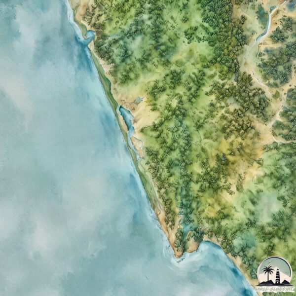
Geography and size of Ramanthali
Size: 34.6 km²
Coastline: 75.1 km
Ocean: Indian Ocean
Sea: Laccadive Sea
Continent: Asia
Ramanthali is a Medium Island spanning 35 km² with a coastline of 75 km.
Archipel: –
Tectonic Plate: Burma – Also known as the Burma Plate, it’s a minor tectonic plate in Southeast Asia, largely covering Burma (Myanmar) and parts of the Indian Ocean. It’s involved in the subduction process under the Eurasian Plate, contributing to seismic activity in the region.
The geographic heart of the island is pinpointed at these coordinates:
Latitude: 12.06317768 / Longitude: 75.19304136
Climate and weather of Ramanthali
Climate Zone: Tropical
Climate Details: Tropical Monsoon Climate
Temperature: Hot
Climate Characteristics: Characterized by heavy rainfall, high humidity, and uniformly high temperatures, but with a distinct short dry season. It features a seasonal reversal of prevailing wind directions.
Topography and nature of Ramanthali
Timezone: UTC+05:30
Timezone places: Asia/Kolkata
Max. Elevation: 178 m
Mean Elevation: 40 m
Vegetation: Open Woodland
Tree Coverage: 49%
The mean elevation is 40 m. The highest elevation on the island reaches approximately 178 meters above sea level. The island is characterized by Plains: Flat, low-lying lands characterized by a maximum elevation of up to 200 meters. On islands, plains are typically coastal lowlands or central flat areas.
Dominating Vegetation: Open Woodland
Characterized by sparsely distributed trees with open canopy allowing sunlight to penetrate, supporting grasses and shrubs underneath. Often found in drier or transitional environments. Ramanthali has a tree cover of 49 %.
Vegetation: 14 vegetation zones – Exceptionally Diverse Island
Islands with more than ten vegetation zones are among the most ecologically rich and varied in the world. These islands are akin to miniature continents, boasting an incredible array of ecosystems. The sheer range of habitats, from high peaks to deep valleys, rainforests to deserts, creates a mosaic of life that is unparalleled. They are crucial for conservation and ecological studies.
Infrastructure and Travelling to Ramanthali
Does the island have a public airport? no.
There is no public and scheduled airport on Ramanthali. The nearest airport is Kannur International Airport, located 37 km away.
Does the island have a major port? no.
There are no major ports on Ramanthali. The closest major port is AZHIKAL (AZHIKKAL), approximately 14 km away.
The mean population of Ramanthali is 629 per km². Ramanthali is Densely Populated. The island belongs to India.
Continuing your journey, Vypīn Island is the next notable island, situated merely km away.
PANDYALA ISLAND MOTORCYCLE RIDE / RIDERS /ROYAL ENFIELD / KANNUR / RAMANTHALI / PAYYANNUR


India is classified as Emerging region: BRIC: Brazil, Russia, India, and China – Economies noted for their rapid growth and increasing influence on global affairs. The level of income is Lower middle income.
News – Latest Updates and Headlines from Ramanthali
Stay informed with the most recent news and important headlines from Ramanthali. Here’s a roundup of the latest developments.
Please note: The data used here has been primarily extracted from satellite readings. Deviations from exact values may occur, particularly regarding the height of elevations and population density. Land area and coastline measurements refer to average values at mean high tide.