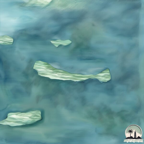
Welcome to Rathbone, a Polar island in the Greenland Sea, part of the majestic Arctic Ocean. This guide offers a comprehensive overview of what makes Rathbone unique – from its geography and climate to its population, infrastructure, and beyond. Dive into the details:
Geography and size of Rathbone
Size: 5.427 km²
Coastline: 16 km
Ocean: Arctic Ocean
Sea: Greenland Sea
Continent: Europe
Rathbone is a Small Island spanning 5.4 km² with a coastline of 16 km.
Archipel: –
Tectonic Plate: North America – Covers North America and parts of the Atlantic and Arctic Oceans, characterized by diverse geological features and varying levels of seismic activity.
The geographic heart of the island is pinpointed at these coordinates:
Latitude: 70.67225217 / Longitude: -21.46111226
Climate and weather of Rathbone
Climate Zone: Polar
Climate Details: Tundra
Temperature: Cold
Climate Characteristics: The tundra climate features long, extremely cold winters and short, cool summers. Vegetation is limited to mosses, lichens, and small shrubs due to the low temperatures and short growing seasons. Biodiversity is low, but some specialized species thrive.
Topography and nature of Rathbone
Timezone: UTC-01:00
Timezone places: America/Scoresbysund
Max. Elevation: 316 m
Mean Elevation: 169 m
Vegetation: Sparse Vegetation
Tree Coverage: 77%
The mean elevation is 169 m. The highest elevation on the island reaches approximately 316 meters above sea level. The island is characterized by Hills: Gently sloping landforms with rounded tops, having a maximum elevation between 200 and 500 meters. Hills contribute to a varied landscape on islands.
Dominating Vegetation: Sparse Vegetation
These regions have limited plant growth, typically due to extreme conditions like aridity or poor soils. Vegetation is scattered and consists of hardy plant species. Rathbone has a tree cover of 77 %.
Vegetation: 3 vegetation zones – Moderately Diverse Island
These islands start to show a broader range of ecological niches. With three vegetation zones, they may offer a mix of ecosystems like coastal areas, inland woods, and perhaps a distinct wetland or dry area. This diversity supports a wider range of flora and fauna, making these islands more ecologically complex than those with minimal diversity.
Infrastructure and Travelling to Rathbone
Does the island have a public airport? no.
There is no public and scheduled airport on Rathbone. The nearest airport is Ittoqqortoormiit Heliport, located 56 km away.
Does the island have a major port? no.
There are no major ports on Rathbone. The closest major port is BOLUNGAVIK, approximately 536 km away.
The mean population of Rathbone is 0 per km². Rathbone is Uninhabited. The island belongs to Denmark.
Continuing your journey, Turner Ø is the next notable island, situated merely km away.
THE ISLAND - Official Trailer (2023) Michael Jai White, Jackson Rathbone
THE ISLAND - Official Trailer (2023) Michael Jai White, Jackson Rathbone.THE ISLAND - Official Trailer (2023) Michael Jai White, Jackson Rathbone
THE ISLAND - Official Trailer (2023) Michael Jai White, Jackson Rathbone.
THE ISLAND - Official Trailer (2023) Michael Jai White, Jackson Rathbone.
GRUESOME DETAILS EMERGE IN LATEST EPSTEIN TRANCHE!
SUBSCRIBE TO THE NEW PAGE! @Rathbonee SUPPORT MY WORK AT PATREON: ...
Fog Island (1945) – Full Classic Mystery Thriller | Suspense Drama Movie
On a stormy island shrouded in fog, a reclusive man invites a group of ...
On a stormy island shrouded in fog, a reclusive man invites a group of guests—each with a dark secret and a reason to fear the ...
The Island (2023) Action Trailer with Michael Jay White & Jackson Rathbone
The Island (2023) when his brother is killed, LAPD officer Mark leaves ...
The Island (2023) when his brother is killed, LAPD officer Mark leaves the city to return to the island he grew up on. Seeking ...
THE ISLAND Official Trailer (2023)
First movie trailer for The island starring Michael jai white.
First movie trailer for The island starring Michael jai white.
1977: OLIVER REED at home in BROOME HALL | Nationwide | Classic Celebrity Interview | BBC Archive
Valerie Singleton takes a trip to Broome Hall in Surrey, the unlikely ...
Valerie Singleton takes a trip to Broome Hall in Surrey, the unlikely home of notorious hell raiser Oliver Reed. Reed is one of the ...
The Island Full Movie |Michael Jai White Jackson Rathbone,Gillian White, Edoardo Costa, Wayne Gordon
The Island full movie |Michael Jai White Jackson Rathbone,Gillian ...
The Island full movie |Michael Jai White Jackson Rathbone,Gillian White, Edoardo Costa, Wayne Gordon How i made $1000 ...
The Twilight Saga: Breaking Dawn - Part 2 (2012-2025) Cast Then and Now #shorts #thetwilightsaga
The Twilight Saga: Breaking Dawn - Part 2 (2012-2025) Cast Then and ...
The Twilight Saga: Breaking Dawn - Part 2 (2012-2025) Cast Then and Now then and now , robert pattinson , twilight , the twilight ...
Michael Jai White's #The Island 🏝️
The Death of Basil Rathbone
Leon Redbone And Dr. John - Frosty The Snowman (HQ)
Christmas 1990 release from the album "Christmas island" Courtesy of ...
Christmas 1990 release from the album "Christmas island" Courtesy of Private Music.
The Real Barbie Movie Trailer - Why play with a Plastic Doll when you can be one 💋💕🌴
Jackson Rathbone Interview: Twilight Wig
Catch Kellan Lutz & Jackson Rathbone at Fan Expo Canada Friday August ...
Catch Kellan Lutz & Jackson Rathbone at Fan Expo Canada Friday August 22-24, 2025 at the Metro Toronto Convention Centre ...
Sherlock Holmes: The Hound of the Baskervilles (1939) Detective Movie, Basil Rathbone, Nigel Bruce
Sherlock Holmes, The Hound of the Baskervilles, (1939), Detective ...
Sherlock Holmes, The Hound of the Baskervilles, (1939), Detective Movie, Basil Rathbone, Nigel Bruce Title: The Hound of the ...
Glenn Beck goes NUCLEAR after hearing the Rhode Island shooter’s identity
Glenn Beck loses it after hearing that the Rhode Island father who ...
Glenn Beck loses it after hearing that the Rhode Island father who murdered members of his family at a hockey game identified as ...
THE ISLAND (2023) Official Trailer | Michael Jai White, Jackson Rathbone, Gillian White
When his brother is killed, LAPD officer Mark (Michael J. White) ...
When his brother is killed, LAPD officer Mark (Michael J. White) leaves the city to return to the island he grew up on. Seeking ...
Ben Shapiro Responds To My Analysis of His Possible Lip Filler! #benshapiro #lipfiller
Ghislaine Maxwell accuser shares new details of alleged torture in new book
The trial of Ghislaine Maxwell is underway and we're hearing new ...
The trial of Ghislaine Maxwell is underway and we're hearing new details from one of her alleged victims. In her book, "Silenced ...
The Island 2023 movieClip Michael Jai White, Jackson Rathbone action thriller | Tia Entertainments
The Island 2023 movieClip Michael Jai White, Jackson Rathbone action ...
The Island 2023 movieClip Michael Jai White, Jackson Rathbone action thriller | Tia Entertainments #603 "When his brother is ...
🇰🇵 Day In My Life in North Korea
Day In My Life in North Korea #shorts.
Day In My Life in North Korea #shorts.
Charlie Kirk was irreplaceable
benshapiro #charliekirk #remembrance.
benshapiro #charliekirk #remembrance.
Twilight (2008) - Vampire Baseball Scene | Movieclips
Twilight - Vampire Baseball: Bella (Kristen Stewart) umpires a game of ...
Twilight - Vampire Baseball: Bella (Kristen Stewart) umpires a game of baseball with the Cullens. BUY THE MOVIE: ...
Treasure Island by Robert Louis Stevenson
Provided to YouTube by The Orchard Enterprises Treasure Island by ...
Provided to YouTube by The Orchard Enterprises Treasure Island by Robert Louis Stevenson · Basil Rathbone Basil Rathbone's ...
A Jewish Rabbi joke 😂
BEFORE you comment, please read: Yes I am aware that the joke is NOT ...
BEFORE you comment, please read: Yes I am aware that the joke is NOT THAT FUNNY. The irony is that it's all the people ...
Reality of wolf scenes shooting | Twilight BEHIND The SCENES | before CGI vs After CGI #shorts#wolf
Like and subscribe for more videos! ∆ I do not own any of these clips. ...
Like and subscribe for more videos! ∆ I do not own any of these clips. I upload them for entertainment purposes! Email me for any ...
Denmark is classified as Developed region: nonG7: Developed economies outside of the Group of Seven, characterized by high income and advanced economic structures. The level of income is High income: OECD.
News – Latest Updates and Headlines from Rathbone
Stay informed with the most recent news and important headlines from Rathbone. Here’s a roundup of the latest developments.
Loading...
Please note: The data used here has been primarily extracted from satellite readings. Deviations from exact values may occur, particularly regarding the height of elevations and population density. Land area and coastline measurements refer to average values at mean high tide.