Raton Grande
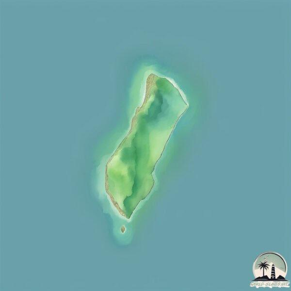
Welcome to Raton Grande, a Temperate island in the South Atlantic Ocean, part of the majestic Atlantic Ocean. This guide offers a comprehensive overview of what makes Raton Grande unique – from its geography and climate to its population, infrastructure, and beyond. Dive into the details:
- Geography and Size: Explore the island’s size and location.
- Climate and Weather: Weather patterns and temperature.
- Topography and Nature: Uncover the natural wonders of the island.
- Infrastructure and Travelling: Insights on reaching, staying, and making the most of your visit.
- News and Headlines: Latest News.
Geography and size of Raton Grande
Size: 0.171 km²
Coastline: 2 km
Ocean: Atlantic Ocean
Sea: South Atlantic Ocean
Continent: South America
Raton Grande is a Tiny Island spanning 0.171 km² with a coastline of 2 km.
Archipel: –
Tectonic Plate: South America – A major plate covering the South American continent and part of the Atlantic Ocean, known for the Andes mountain range and significant seismic and volcanic activity.
The geographic heart of the island is pinpointed at these coordinates:
Latitude: -27.47598021 / Longitude: -48.56253635
Climate and weather of Raton Grande
Climate Zone: Temperate
Climate Details: Humid Subtropical Climate
Temperature: Hot Summer
Climate Characteristics: With continuous rainfall and hot summers, this climate is common in some coastal regions, supporting diverse vegetation.
Topography and nature of Raton Grande
Timezone: UTC-03:00
Timezone places: America/Sao_Paulo
Max. Elevation: -2 m
Mean Elevation: -3 m
Vegetation: Evergreen Broadleaf Forest
Tree Coverage: 67%
The mean elevation is -3 m. Remarkably, this unique island barely emerges above the sea level, showcasing nature’s fascinating interplay with the ocean. The island is characterized by Plains: Flat, low-lying lands characterized by a maximum elevation of up to 200 meters. On islands, plains are typically coastal lowlands or central flat areas.
Dominating Vegetation: Evergreen Broadleaf Forest
Characterized by dense, lush canopies of broadleaf trees that retain their leaves year-round. These forests are typically found in tropical and subtropical regions and are known for their high biodiversity. Raton Grande has a tree cover of 67 %.
Vegetation: 1 vegetation zones – Minimal Diversity Island
These islands exhibit the most basic level of ecological diversity, often characterized by a single dominant vegetation type. This could be due to extreme environmental conditions, limited land area, or significant human impact. They represent unique ecosystems where specific species have adapted to thrive in these singular environments.
Infrastructure and Travelling to Raton Grande
Does the island have a public airport? no.
There is no public and scheduled airport on Raton Grande. The nearest airport is Batalhão de Operações Aéreas do CBMSC Heliport, located 15 km away.
Does the island have a major port? no.
There are no major ports on Raton Grande. The closest major port is ITAJAI, approximately 62 km away.
The mean population of Raton Grande is 0 per km². Raton Grande is Uninhabited. The island belongs to Brazil.
Continuing your journey, Ilha de Santa Catarina is the next notable island, situated merely km away.
How Giant Rats Clear Landmines 🤔


Brazil is classified as Emerging region: BRIC: Brazil, Russia, India, and China – Economies noted for their rapid growth and increasing influence on global affairs. The level of income is Upper middle income.
News – Latest Updates and Headlines from Raton Grande
Stay informed with the most recent news and important headlines from Raton Grande. Here’s a roundup of the latest developments.
Please note: The data used here has been primarily extracted from satellite readings. Deviations from exact values may occur, particularly regarding the height of elevations and population density. Land area and coastline measurements refer to average values at mean high tide.