Reads
Welcome to Reads, a Temperate island in the North Sea, part of the majestic Atlantic Ocean. This guide offers a comprehensive overview of what makes Reads unique – from its geography and climate to its population, infrastructure, and beyond. Dive into the details:
- Geography and Size: Explore the island’s size and location.
- Climate and Weather: Weather patterns and temperature.
- Topography and Nature: Uncover the natural wonders of the island.
- Infrastructure and Travelling: Insights on reaching, staying, and making the most of your visit.
- News and Headlines: Latest News.
Geography and size of Reads
Size: 1.059 km²
Coastline: 6.7 km
Ocean: Atlantic Ocean
Sea: North Sea
Continent: Europe
Reads is a Small Island spanning 1.1 km² with a coastline of 6.7 km.
Archipel: British Isles – A group of islands off the northwest coast of mainland Europe, including Great Britain, Ireland, and over 6,000 smaller islands, known for their rich history and cultural diversity.
Tectonic Plate: Eurasia – One of the world’s largest tectonic plates, the Eurasian Plate covers a significant portion of Europe and Asia. It’s characterized by diverse geological features, including the Ural Mountains, the European Plain, and the Himalayas formed from its collision with the Indian Plate.
The geographic heart of the island is pinpointed at these coordinates:
Latitude: 53.6869825 / Longitude: -0.55297936
Climate and weather of Reads
Climate Zone: Temperate
Climate Details: Temperate Oceanic Climate
Temperature: Warm Summer
Climate Characteristics: Known for its moderate year-round temperatures with ample rainfall and no dry season. Warm summers are characteristic.
Topography and nature of Reads
Timezone: UTC±00:00
Timezone places: Europe/London
Max. Elevation: 3 m
Mean Elevation: 0 m
Vegetation: Agricultural Mosaic
Tree Coverage: 54%
The mean elevation is 0 m. The highest elevation on the island reaches approximately 3 meters above sea level. The island is characterized by Plains: Flat, low-lying lands characterized by a maximum elevation of up to 200 meters. On islands, plains are typically coastal lowlands or central flat areas.
Dominating Vegetation: Agricultural Mosaic
A mix of cropland and natural vegetation, often seen in rural landscapes where agricultural fields are interspersed with patches of natural habitats. Reads has a tree cover of 54 %.
Vegetation: 2 vegetation zones – Low Diversity Island
Islands with two distinct vegetation zones offer slightly more ecological variety. These zones could be due to differences in elevation, moisture, or other environmental factors. While still limited in biodiversity, these islands may offer a contrast between the two zones, such as a coastline with mangroves and an inland area with grassland.
Infrastructure and Travelling to Reads
Does the island have a public airport? no.
There is no public and scheduled airport on Reads. The nearest airport is Humberside Airport, located 23 km away.
Does the island have a major port? no.
There are no major ports on Reads. The closest major port is NEW HOLLAND, approximately 18 km away.
The mean population of Reads is 31 per km². Reads is Gently Populated. The island belongs to United Kingdom.
The name of the island resonates across different cultures and languages. Here is how it is known around the world: Arabic: بريطانيا العظمى; German: Großbritannien; Spanish: Gran Bretaña; French: Grande-Bretagne; Portuguese: Grã-Bretanha; Russian: Великобритания; Chinese: 大不列顛島
Continuing your journey, Great Britain is the next notable island, situated merely km away.
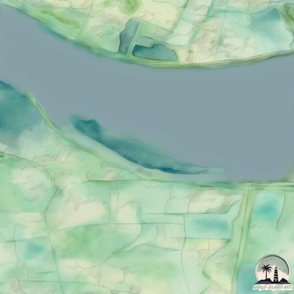
Parrot Anafi, a sunset flight over Reads Island on the river humber.


![The Island Inn: Amberjack Shores Book 1 [Full Audiobook] Beach Read | Sweet Romance | Womens Fiction](https://i.ytimg.com/vi/PCckA_y-B10/mqdefault.jpg)
![The Island Guest: Amberjack Shores Book 4 [Full Audiobook] Beach Read | Romance | Womens Fiction](https://i.ytimg.com/vi/lht93_TS1HY/mqdefault.jpg)


![Island Secrets: Amberjack Shores Book 2 [Full Audiobook] Beach Read | Sweet Romance | Womens Fiction](https://i.ytimg.com/vi/bB6uU8FVcIc/mqdefault.jpg)


![Island Storms: Amberjack Shores Book 3 [Full Audiobook] Beach Reads | Sweet Romance | Womens Fiction](https://i.ytimg.com/vi/Dj0BSJ86O_k/mqdefault.jpg)


United Kingdom is classified as Developed region: G7: Group of Seven – Major advanced economies, including Canada, France, Germany, Italy, Japan, the United Kingdom, and the United States. The level of income is High income: OECD.
News – Latest Updates and Headlines from Reads
Stay informed with the most recent news and important headlines from Reads. Here’s a roundup of the latest developments.
Please note: The data used here has been primarily extracted from satellite readings. Deviations from exact values may occur, particularly regarding the height of elevations and population density. Land area and coastline measurements refer to average values at mean high tide.