Recalada
Welcome to Recalada, a Polar island in the South Pacific Ocean, part of the majestic Pacific Ocean. This guide offers a comprehensive overview of what makes Recalada unique – from its geography and climate to its population, infrastructure, and beyond. Dive into the details:
- Geography and Size: Explore the island’s size and location.
- Climate and Weather: Weather patterns and temperature.
- Topography and Nature: Uncover the natural wonders of the island.
- Infrastructure and Travelling: Insights on reaching, staying, and making the most of your visit.
- News and Headlines: Latest News.
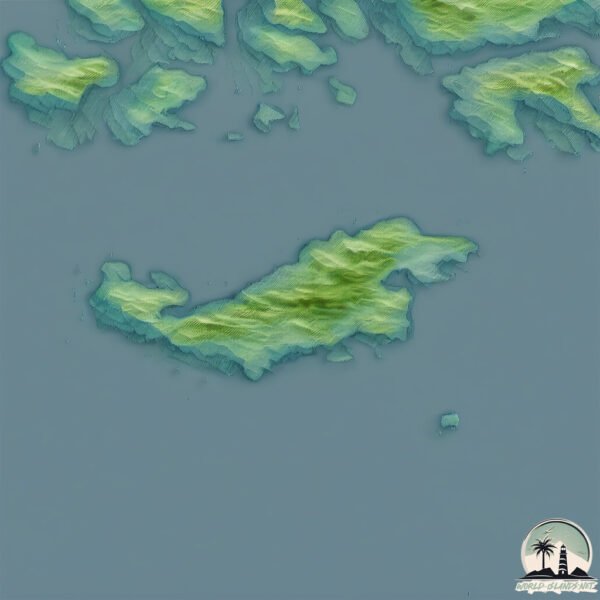
Geography and size of Recalada
Size: 69.3 km²
Coastline: 105.2 km
Ocean: Pacific Ocean
Sea: South Pacific Ocean
Continent: South America
Recalada is a Medium Island spanning 69 km² with a coastline of 105 km.
Archipel: Andes fueguinos – A subregion of Tierra del Fuego in the southernmost tip of South America, known for its rugged mountain landscapes and remote beauty.
Tectonic Plate: Scotia – Situated in the Southern Ocean, surrounding the Scotia Sea, between South America and Antarctica, known for the Scotia Arc and active seismicity.
The geographic heart of the island is pinpointed at these coordinates:
Latitude: -53.30340002 / Longitude: -74.15779092
Climate and weather of Recalada
Climate Zone: Polar
Climate Details: Tundra
Temperature: Cold
Climate Characteristics: The tundra climate features long, extremely cold winters and short, cool summers. Vegetation is limited to mosses, lichens, and small shrubs due to the low temperatures and short growing seasons. Biodiversity is low, but some specialized species thrive.
Topography and nature of Recalada
Timezone: UTC-04:00
Timezone places: America/La_Paz
Max. Elevation: 335 m
Mean Elevation: 113 m
Vegetation: Evergreen Broadleaf Forest
Tree Coverage: 68%
The mean elevation is 113 m. The highest elevation on the island reaches approximately 335 meters above sea level. The island is characterized by Hills: Gently sloping landforms with rounded tops, having a maximum elevation between 200 and 500 meters. Hills contribute to a varied landscape on islands.
Dominating Vegetation: Evergreen Broadleaf Forest
Characterized by dense, lush canopies of broadleaf trees that retain their leaves year-round. These forests are typically found in tropical and subtropical regions and are known for their high biodiversity. Recalada has a tree cover of 68 %.
Vegetation: 7 vegetation zones – Very Highly Diverse Island
Islands in this range are ecological powerhouses, showcasing a wide array of vegetation zones. Each zone, from lush rainforests to arid scrublands, coastal mangroves to mountainous regions, contributes to a complex and interdependent ecosystem. These islands are often hotspots of biodiversity, supporting numerous species and intricate ecological processes.
Infrastructure and Travelling to Recalada
Does the island have a public airport? no.
There is no public and scheduled airport on Recalada. The nearest airport is Lieutenant Julio Gallardo Airport, located 245 km away.
Does the island have a major port? no.
There are no major ports on Recalada. The closest major port is PUERTO NATALES, approximately 239 km away.
The mean population of Recalada is 7 per km². Recalada is Gently Populated. The island belongs to Chile.
Continuing your journey, Beauclerk is the next notable island, situated merely km away.
Esloras Tv Náutica Recalada - Almacen náutico


Chile is classified as Emerging region: G20: Group of Twenty – Major economies comprising both developed and emerging countries, representing the world’s largest economies. The level of income is Upper middle income.
News – Latest Updates and Headlines from Recalada
Stay informed with the most recent news and important headlines from Recalada. Here’s a roundup of the latest developments.
- DIAMOND ISLAND, Bulk Carrier - Details and current position - IMO 1057177 - VesselFinderon 16 July 2025
DIAMOND ISLAND, Bulk Carrier - Details and current position - IMO 1057177 VesselFinder
- ELIKI, Bulk Carrier - Details and current position - IMO 9470325 - VesselFinderon 5 October 2022
ELIKI, Bulk Carrier - Details and current position - IMO 9470325 VesselFinder
- SEAWAYS SAMAR, Chemical/Oil Products Tanker - Details and current position - IMO 9470284 - VesselFinderon 4 October 2022
SEAWAYS SAMAR, Chemical/Oil Products Tanker - Details and current position - IMO 9470284 VesselFinder
- UNION TRADER, Bulk Carrier - Details and current position - IMO 9445710 - VesselFinderon 4 October 2022
UNION TRADER, Bulk Carrier - Details and current position - IMO 9445710 VesselFinder
- LEGEND I, Bulk Carrier - Details and current position - IMO 9523483 - VesselFinderon 4 October 2022
LEGEND I, Bulk Carrier - Details and current position - IMO 9523483 VesselFinder
- CLARA INSIGNIA, Bulk Carrier - Details and current position - IMO 9800427 - VesselFinderon 3 October 2022
CLARA INSIGNIA, Bulk Carrier - Details and current position - IMO 9800427 VesselFinder
- MIKE BAY, Bulk Carrier - Details and current position - IMO 9481958 - VesselFinderon 3 October 2022
MIKE BAY, Bulk Carrier - Details and current position - IMO 9481958 VesselFinder
- MIDNIGHT GLORY, Chemical/Oil Products Tanker - Details and current position - IMO 9877808 - VesselFinderon 3 October 2022
MIDNIGHT GLORY, Chemical/Oil Products Tanker - Details and current position - IMO 9877808 VesselFinder
- IWAGI ISLAND, Bulk Carrier - Details and current position - IMO 9846251 - VesselFinderon 3 October 2022
IWAGI ISLAND, Bulk Carrier - Details and current position - IMO 9846251 VesselFinder
- PACIFIC STAR, Bulk Carrier - Details and current position - IMO 9311402 - VesselFinderon 3 October 2022
PACIFIC STAR, Bulk Carrier - Details and current position - IMO 9311402 VesselFinder
Please note: The data used here has been primarily extracted from satellite readings. Deviations from exact values may occur, particularly regarding the height of elevations and population density. Land area and coastline measurements refer to average values at mean high tide.