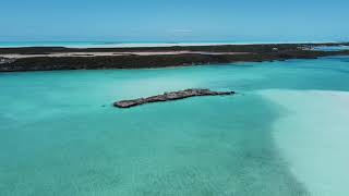
Red Shank Cay
Welcome to Red Shank Cay, a Tropical island in the North Atlantic Ocean, part of the majestic Atlantic Ocean. This guide offers a comprehensive overview of what makes Red Shank Cay unique – from its geography and climate to its population, infrastructure, and beyond. Dive into the details:
- Geography and Size: Explore the island’s size and location.
- Climate and Weather: Weather patterns and temperature.
- Topography and Nature: Uncover the natural wonders of the island.
- Infrastructure and Travelling: Insights on reaching, staying, and making the most of your visit.
- News and Headlines: Latest News.
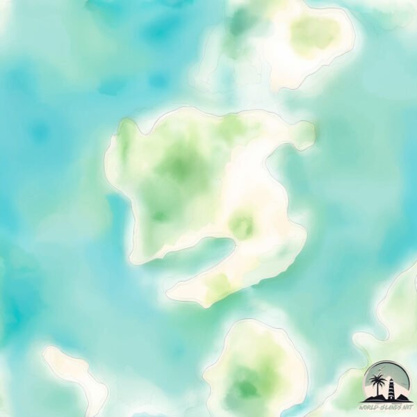
Geography and size of Red Shank Cay
Size: 0.924 km²
Coastline: 5.8 km
Ocean: Atlantic Ocean
Sea: North Atlantic Ocean
Continent: North America
Red Shank Cay is a Tiny Island spanning 0.924 km² with a coastline of 5.8 km.
Archipel: Bahama Islands – An archipelago in the Atlantic Ocean, known for their stunning beaches, coral reefs, and vibrant culture.
Tectonic Plate: North America – Covers North America and parts of the Atlantic and Arctic Oceans, characterized by diverse geological features and varying levels of seismic activity.
The geographic heart of the island is pinpointed at these coordinates:
Latitude: 24.39413597 / Longitude: -77.77111381
Climate and weather of Red Shank Cay
Climate Zone: Tropical
Climate Details: Tropical Savanna, Wet
Temperature: Hot
Climate Characteristics: Defined by distinct wet and dry seasons with high temperatures year-round. Pronounced rainfall occurs during the wet season, while the dry season is marked by drought.
Topography and nature of Red Shank Cay
Timezone: UTC-05:00
Timezone places: America/New_York
Max. Elevation: 4 m
Mean Elevation: 3 m
Vegetation: Herbaceous Cover
Tree Coverage: 55%
The mean elevation is 3 m. The highest elevation on the island reaches approximately 4 meters above sea level. The island is characterized by Plains: Flat, low-lying lands characterized by a maximum elevation of up to 200 meters. On islands, plains are typically coastal lowlands or central flat areas.
Dominating Vegetation: Herbaceous Cover
Comprising mainly of grasses, herbs, and ferns, these areas are common in prairies, meadows, and savannas, and can vary widely in species composition. Red Shank Cay has a tree cover of 55 %.
Vegetation: 2 vegetation zones – Low Diversity Island
Islands with two distinct vegetation zones offer slightly more ecological variety. These zones could be due to differences in elevation, moisture, or other environmental factors. While still limited in biodiversity, these islands may offer a contrast between the two zones, such as a coastline with mangroves and an inland area with grassland.
Infrastructure and Travelling to Red Shank Cay
Does the island have a public airport? no.
There is no public and scheduled airport on Red Shank Cay. The nearest airport is Congo Town Airport, located 32 km away.
Does the island have a major port? no.
There are no major ports on Red Shank Cay. The closest major port is CLIFTON PIER, approximately 71 km away.
The mean population of Red Shank Cay is 1 per km². Red Shank Cay is Gently Populated. The island belongs to Bahamas.
Continuing your journey, Big Wood Cay is the next notable island, situated merely km away.
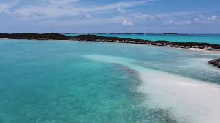
A small island all to ourselves. Redshank Cays Beach in the Exumas. #exuma #beach #caribbeanislands


Bahamas is classified as Developing region: Regions characterized by lower income levels, with economies in the process of industrialization and modernization. The level of income is High income: nonOECD.
News – Latest Updates and Headlines from Red Shank Cay
Stay informed with the most recent news and important headlines from Red Shank Cay. Here’s a roundup of the latest developments.
Please note: The data used here has been primarily extracted from satellite readings. Deviations from exact values may occur, particularly regarding the height of elevations and population density. Land area and coastline measurements refer to average values at mean high tide.