Welcome to Relief, a Continental island in the Beaufort Sea, part of the majestic Arctic Ocean. This guide offers a comprehensive overview of what makes Relief unique – from its geography and climate to its population, infrastructure, and beyond. Dive into the details:
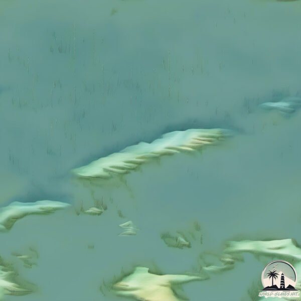
Geography and size of Relief
Size: 1.894 km²
Coastline: 18.8 km
Ocean: Arctic Ocean
Sea: Beaufort Sea
Continent: North America
Relief is a Small Island spanning 1.9 km² with a coastline of 18.8 km.
Archipel: –
Tectonic Plate: North America – Covers North America and parts of the Atlantic and Arctic Oceans, characterized by diverse geological features and varying levels of seismic activity.
The geographic heart of the island is pinpointed at these coordinates:
Latitude: 70.15267453 / Longitude: -130.81755377
Climate and weather of Relief
Climate Zone: Continental
Climate Details: Subarctic Climate
Temperature: Cold Summer
Climate Characteristics: Characterized by long, extremely cold winters and short, cool summers, often found in northern latitudes of North America and Eurasia.
Topography and nature of Relief
Timezone: UTC-07:00
Timezone places: America/Denver
Max. Elevation: -5 m
Mean Elevation: -5 m
Vegetation: Herbaceous Cover
Tree Coverage: 26%
The mean elevation is -5 m. Remarkably, this unique island barely emerges above the sea level, showcasing nature’s fascinating interplay with the ocean. The island is characterized by Plains: Flat, low-lying lands characterized by a maximum elevation of up to 200 meters. On islands, plains are typically coastal lowlands or central flat areas.
Dominating Vegetation: Herbaceous Cover
Comprising mainly of grasses, herbs, and ferns, these areas are common in prairies, meadows, and savannas, and can vary widely in species composition. Relief has a tree cover of 26 %.
Vegetation: 1 vegetation zones – Minimal Diversity Island
These islands exhibit the most basic level of ecological diversity, often characterized by a single dominant vegetation type. This could be due to extreme environmental conditions, limited land area, or significant human impact. They represent unique ecosystems where specific species have adapted to thrive in these singular environments.
Infrastructure and Travelling to Relief
Does the island have a public airport? no.
There is no public and scheduled airport on Relief. The nearest airport is Tuktoyaktuk / James Gruben Airport, located 254 km away.
Does the island have a major port? no.
There are no major ports on Relief. The closest major port is TUKTOYAKTUK, approximately 251 km away.
The mean population of Relief is 0 per km². Relief is Uninhabited. The island belongs to Canada.
Continuing your journey, Thumb is the next notable island, situated merely km away.
Barry Island in the Stream Comic Relief 2009
Bryn West and Vanessa Jenkins.Barry Island in the Stream Comic Relief 2009
Bryn West and Vanessa Jenkins.
Bryn West and Vanessa Jenkins.
Brain Coral #science #sciencefacts #shorts
Brain Coral Discover the incredible world of marine life with the ...
Brain Coral Discover the incredible world of marine life with the fascinating Brain Coral, aptly named for its resemblance to the ...
Invisible Island in the Pacific Ocean 🏝️ The Great Pacific Garbage Patch 🤯
Did you know there's a massive ""island"" in the Pacific Ocean that ...
Did you know there's a massive ""island"" in the Pacific Ocean that isn't on any map? That's because it's not land—it's a floating ...
Bryn and Nessa - (Barry) Islands In The Stream | Comic Relief Does Top of the Pops (2009)
GavinAndStacey #TOTP #RobBrydon.
GavinAndStacey #TOTP #RobBrydon.
Iceland 4K - Scenic Relaxation with Beautiful Relaxing Music for Stress Relief, Peaceful Piano Music
When it comes to natural beauty, Iceland is hard to beat. With its ...
When it comes to natural beauty, Iceland is hard to beat. With its towering mountains, serene lakes, and otherworldly landscapes, ...
Barry Gibb, Kenny Rogers & Dolly Parton - Island In The Stream (1983-1997)
Barry Gibb Kenny Rogers Dolly Parton Island In The Stream The Bee Gees ...
Barry Gibb Kenny Rogers Dolly Parton Island In The Stream The Bee Gees Soft rock country pop most popular songs.
Shutter Island | *FINAL SCENE*
Relief efforts in remote islands
(17 Jan 2005) SHOTLIST Chouldhari, Andaman & Nicobar Islands, Recent ...
(17 Jan 2005) SHOTLIST Chouldhari, Andaman & Nicobar Islands, Recent 1. Wide of camp with lots of tents 2. Man collecting ...
Win a Dungeons & Dragons: Island of Oxventure Experience with Comic Relief!
For details and to enter the prize draw, visit: ...
Islands In the Stream Live on Let's Dance for Comic Relief
Ruth Jones and Rob Brydon AKA Bryn and Nessa - and Tom Jones perform ...
Ruth Jones and Rob Brydon AKA Bryn and Nessa - and Tom Jones perform their comic relief single Islands in the stream live on ...
Island Paradise: 6 Hours of Tropical Relief & Soothing Ocean Sounds (4K Video)
Let's drift away and spend the day on an island paradise, surrounded ...
Let's drift away and spend the day on an island paradise, surrounded by soothing ocean sounds Today's extra-big dose of ...
Australia’s INSANE Inland Sea Plan 🌊🇦🇺
Did You Know Australia Almost Built an Inland Sea? Imagine turning ...
Did You Know Australia Almost Built an Inland Sea? Imagine turning Australia's vast, dry deserts into a massive inland sea.
'It is not turning back,' says Jamaica resident as Hurricane Melissa nears
Residents in Jamaica's Kingston community of Harbour View made their ...
Residents in Jamaica's Kingston community of Harbour View made their final preparations as Hurricane Melissa began lashing ...
4K San Juan Islands, Washington | Winds Sounds – For Stress Relief, Sleep, Study, White Noise
During fall and winter, wind is a constant in the San Juan Islands, ...
During fall and winter, wind is a constant in the San Juan Islands, Washington. Get on a ferry or climb on top of a ridge, and you'll ...
Tahiti Dream: 3 Hour Meditation Video For Stress Relief
Watch our newest 4K French Polynesia escape (The Softest Beach Sounds): ...
Watch our newest 4K French Polynesia escape (The Softest Beach Sounds): ...
Relief in eastern Vancouver Island towns as Highway 4 reopens
The highway, which connects Tofino, Ucluelet and Port Alberni to the ...
The highway, which connects Tofino, Ucluelet and Port Alberni to the rest of Vancouver Island, is now partially re-opened.
Surveying island relief effort
Australian Defence Force teams on Operation Tonga Assist 2022 are ...
Australian Defence Force teams on Operation Tonga Assist 2022 are working together to ensure personnel and equipment can ...
Relief Delivered to Hurricane-Hit Islands
Samaritan's Purse provided water, medical care, tarps, solar lights, ...
Samaritan's Purse provided water, medical care, tarps, solar lights, and more to those in the Caribbean left in need by Hurricane ...
Dead Island 2 SCAMMED Us 😞... #shorts #deadisland2
Dead Island 2 SCAMMED Us... #shorts #deadisland2.
Dead Island 2 SCAMMED Us... #shorts #deadisland2.
Hawaiian Islands relief map preservation effort underway
Stunning examples of raised relief maps are tucked away in the lobby ...
Stunning examples of raised relief maps are tucked away in the lobby of St. John Plant Science Lab on the University of Hawaii at ...
Barry Islands In The Stream (Comic Relief 2009) TOTP
Performing the Comic relief song on TOTP 13-03-09.
Performing the Comic relief song on TOTP 13-03-09.
Why do Rivers Curve?
Rivers become curvier and curvier until they bump into themselves. ...
Rivers become curvier and curvier until they bump into themselves. Then, lakes follow the route of least resistance and connect to ...
King’s Island Flood Relief Scheme
Minister Kieran O'Donnell announced the appointment of Galway-based ...
Minister Kieran O'Donnell announced the appointment of Galway-based Ward & Burke as contractors for the King's Island Flood ...
Long-term relief sought for Hawaii island
Long-term relief sought for Hawaii island.
Long-term relief sought for Hawaii island.
'Soul relief': On Greek island, bees help people with mental health issues
The Leros cooperative employs 13 salaried workers, supervised by ...
The Leros cooperative employs 13 salaried workers, supervised by specialist beekeepers, in addition to a team of nurses and ...
Canada is classified as Developed region: G7: Group of Seven – Major advanced economies, including Canada, France, Germany, Italy, Japan, the United Kingdom, and the United States. The level of income is High income: OECD.
News – Latest Updates and Headlines from Relief
Stay informed with the most recent news and important headlines from Relief. Here’s a roundup of the latest developments.
Loading...
Please note: The data used here has been primarily extracted from satellite readings. Deviations from exact values may occur, particularly regarding the height of elevations and population density. Land area and coastline measurements refer to average values at mean high tide.