Rodrigues
Welcome to Rodrigues, a Tropical island in the Indian Ocean, part of the majestic Indian Ocean. This guide offers a comprehensive overview of what makes Rodrigues unique – from its geography and climate to its population, infrastructure, and beyond. Dive into the details:
- Geography and Size: Explore the island’s size and location.
- Climate and Weather: Weather patterns and temperature.
- Topography and Nature: Uncover the natural wonders of the island.
- Infrastructure and Travelling: Insights on reaching, staying, and making the most of your visit.
- News and Headlines: Latest News.
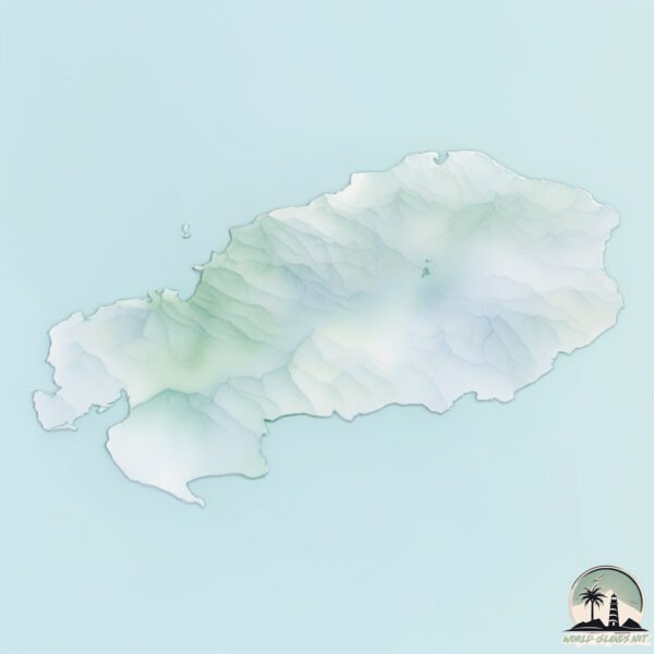
Geography and size of Rodrigues
Size: 109.3 km²
Coastline: 69.5 km
Ocean: Indian Ocean
Sea: Indian Ocean
Continent: Seven seas (open ocean)
Rodrigues is a Large Island spanning 109 km² with a coastline of 69 km.
Archipel: Mascarene Islands – Located in the Indian Ocean, these islands, including Mauritius and Réunion, are known for their unique wildlife and vibrant cultures.
Tectonic Plate: Somalia – A large tectonic plate covering the Horn of Africa and parts of the Indian Ocean, known for the East African Rift where it’s splitting away from the African Plate.
The geographic heart of the island is pinpointed at these coordinates:
Latitude: -19.71628548 / Longitude: 63.42171894
Climate and weather of Rodrigues
Climate Zone: Tropical
Climate Details: Tropical Savanna, Wet
Temperature: Hot
Climate Characteristics: Defined by distinct wet and dry seasons with high temperatures year-round. Pronounced rainfall occurs during the wet season, while the dry season is marked by drought.
Topography and nature of Rodrigues
Timezone: UTC+04:00
Timezone places: Asia/Dubai
Max. Elevation: 337 m
Mean Elevation: 122 m
Vegetation: Evergreen Broadleaf Forest
Tree Coverage: 39%
The mean elevation is 122 m. The highest elevation on the island reaches approximately 337 meters above sea level. The island is characterized by Hills: Gently sloping landforms with rounded tops, having a maximum elevation between 200 and 500 meters. Hills contribute to a varied landscape on islands.
Dominating Vegetation: Evergreen Broadleaf Forest
Characterized by dense, lush canopies of broadleaf trees that retain their leaves year-round. These forests are typically found in tropical and subtropical regions and are known for their high biodiversity. Rodrigues has a tree cover of 39 %.
Vegetation: 11 vegetation zones – Exceptionally Diverse Island
Islands with more than ten vegetation zones are among the most ecologically rich and varied in the world. These islands are akin to miniature continents, boasting an incredible array of ecosystems. The sheer range of habitats, from high peaks to deep valleys, rainforests to deserts, creates a mosaic of life that is unparalleled. They are crucial for conservation and ecological studies.
Infrastructure and Travelling to Rodrigues
Does the island have a public airport? yes.
Rodrigues has a public and scheduled airport. The following airports are located on this island: Sir Charles Gaetan Duval Airport.
Does the island have a major port? yes.
Rodrigues is home to a major port. The following ports are situated on the island: PORT MATHURIN.
The mean population of Rodrigues is 401 per km². Rodrigues is Moderately Inhabited. The island belongs to Mauritius.
Continuing your journey, Mauritius is the next notable island, situated merely km away.
Is Rodrigues island that much better than Mauritius? Check inside!


Mauritius is classified as Developing region: Regions characterized by lower income levels, with economies in the process of industrialization and modernization. The level of income is Upper middle income.
News – Latest Updates and Headlines from Rodrigues
Stay informed with the most recent news and important headlines from Rodrigues. Here’s a roundup of the latest developments.
Please note: The data used here has been primarily extracted from satellite readings. Deviations from exact values may occur, particularly regarding the height of elevations and population density. Land area and coastline measurements refer to average values at mean high tide.