Rote
Welcome to Rote, a Tropical island in the Savu Sea, part of the majestic Indian Ocean. This guide offers a comprehensive overview of what makes Rote unique – from its geography and climate to its population, infrastructure, and beyond. Dive into the details:
- Geography and Size: Explore the island’s size and location.
- Climate and Weather: Weather patterns and temperature.
- Topography and Nature: Uncover the natural wonders of the island.
- Infrastructure and Travelling: Insights on reaching, staying, and making the most of your visit.
- News and Headlines: Latest News.
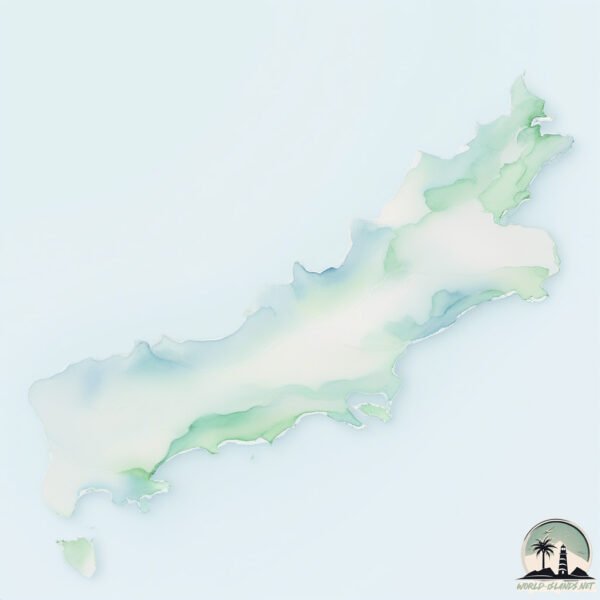
Geography and size of Rote
Size: 1254 km²
Coastline: 381 km
Ocean: Indian Ocean
Sea: Savu Sea
Continent: Asia
Rote is a Very Large Island spanning 1254 km² with a coastline of 381 km.
Archipel: Malay Archipelago – The world’s largest archipelago, located between mainland Southeast Asia and Australia, known for its immense biodiversity and cultural diversity.
Tectonic Plate: Timor – A small tectonic plate in the Timor region, primarily under the Timor Sea. It’s involved in the collision between the Australian and Eurasian plates, contributing to the region’s seismic activity and the uplift of the island of Timor.
The geographic heart of the island is pinpointed at these coordinates:
Latitude: -10.720425 / Longitude: 123.13445733
Climate and weather of Rote
Climate Zone: Tropical
Climate Details: Tropical Savanna, Wet
Temperature: Hot
Climate Characteristics: Defined by distinct wet and dry seasons with high temperatures year-round. Pronounced rainfall occurs during the wet season, while the dry season is marked by drought.
Topography and nature of Rote
Timezone: UTC+08:00
Timezone places: Australia/Perth
Max. Elevation: 397 m
Mean Elevation: 87 m
Vegetation: Cultivated Land
Tree Coverage: 33%
The mean elevation is 87 m. The highest elevation on the island reaches approximately 397 meters above sea level. The island is characterized by Hills: Gently sloping landforms with rounded tops, having a maximum elevation between 200 and 500 meters. Hills contribute to a varied landscape on islands.
Dominating Vegetation: Cultivated Land
Areas dedicated to agricultural activities, growing crops like grains, vegetables, and fruits. These lands are usually human-modified landscapes. Rote has a tree cover of 33 %.
Vegetation: 11 vegetation zones – Exceptionally Diverse Island
Islands with more than ten vegetation zones are among the most ecologically rich and varied in the world. These islands are akin to miniature continents, boasting an incredible array of ecosystems. The sheer range of habitats, from high peaks to deep valleys, rainforests to deserts, creates a mosaic of life that is unparalleled. They are crucial for conservation and ecological studies.
Infrastructure and Travelling to Rote
Does the island have a public airport? no.
There is no public and scheduled airport on Rote. The nearest airport is El Tari Airport, located 43 km away.
Does the island have a major port? no.
There are no major ports on Rote. The closest major port is KUPANG, approximately 37 km away.
The mean population of Rote is 115 per km². Rote is Moderately Inhabited. The island belongs to Indonesia.
The name of the island resonates across different cultures and languages. Here is how it is known around the world: Arabic: جزيرة روتي; German: Roti; Spanish: Isla de Roti; French: Rote; Portuguese: Roti; Russian: Роти; Chinese: 羅地島
Continuing your journey, Pulau Ndana is the next notable island, situated merely km away.
I explored the MOST SOUTHERN Indonesian Island - ROTE ISLAND


Indonesia is classified as Emerging region: MIKT: Mexico, Indonesia, South Korea, and Turkey – Economies recognized for their development potential and emerging market status. The level of income is Lower middle income.
News – Latest Updates and Headlines from Rote
Stay informed with the most recent news and important headlines from Rote. Here’s a roundup of the latest developments.
Social Media Posts about Rote
Please note: The data used here has been primarily extracted from satellite readings. Deviations from exact values may occur, particularly regarding the height of elevations and population density. Land area and coastline measurements refer to average values at mean high tide.