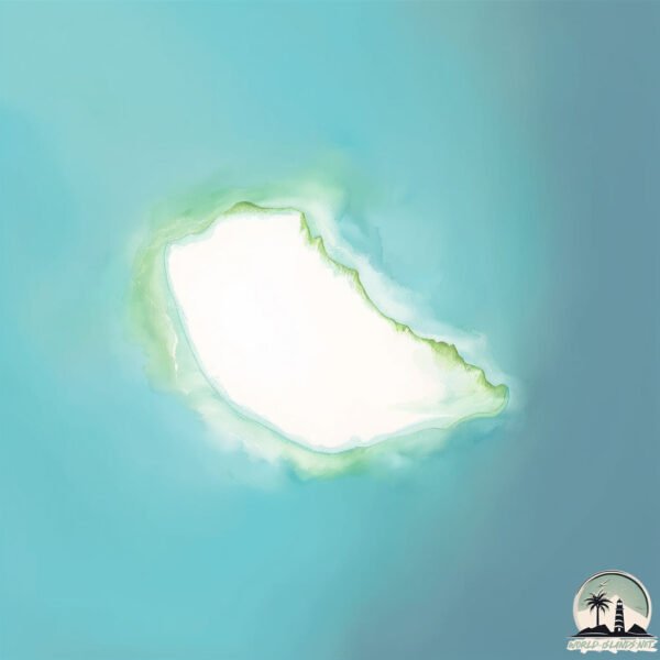
Welcome to Rukada, a Dry island in the Red Sea, part of the majestic Indian Ocean. This guide offers a comprehensive overview of what makes Rukada unique – from its geography and climate to its population, infrastructure, and beyond. Dive into the details:
Geography and size of Rukada
Size: 0.134 km²
Coastline: 1.5 km
Ocean: Indian Ocean
Sea: Red Sea
Continent: Asia
Rukada is a Tiny Island spanning 0.134 km² with a coastline of 1.5 km.
Archipel: –
Tectonic Plate: Arabia – A major tectonic plate covering the Arabian Peninsula and parts of the Middle East. The plate is primarily continental and known for its collision with the Eurasian Plate, leading to the uplift of the Zagros Mountains.
The geographic heart of the island is pinpointed at these coordinates:
Latitude: 16.34886456 / Longitude: 42.49927224
Climate and weather of Rukada
Climate Zone: Dry
Climate Details: Hot Deserts Climate
Temperature: Hot
Climate Characteristics: Dominated by extremely hot temperatures, this climate is marked by minimal rainfall and barren landscapes. Nights often experience drastic temperature drops.
Topography and nature of Rukada
Timezone: UTC+03:00
Timezone places: Asia/Riyadh
Max. Elevation: -3 m
Mean Elevation: -3 m
Vegetation: Sparse Vegetation
Tree Coverage: 14%
The mean elevation is -3 m. Remarkably, this unique island barely emerges above the sea level, showcasing nature’s fascinating interplay with the ocean. The island is characterized by Plains: Flat, low-lying lands characterized by a maximum elevation of up to 200 meters. On islands, plains are typically coastal lowlands or central flat areas.
Dominating Vegetation: Sparse Vegetation
These regions have limited plant growth, typically due to extreme conditions like aridity or poor soils. Vegetation is scattered and consists of hardy plant species. Rukada has a tree cover of 14 %.
Vegetation: 1 vegetation zones – Minimal Diversity Island
These islands exhibit the most basic level of ecological diversity, often characterized by a single dominant vegetation type. This could be due to extreme environmental conditions, limited land area, or significant human impact. They represent unique ecosystems where specific species have adapted to thrive in these singular environments.
Infrastructure and Travelling to Rukada
Does the island have a public airport? no.
There is no public and scheduled airport on Rukada. The nearest airport is Jizan Regional Airport / King Abdullah bin Abdulaziz Airport, located 62 km away.
Does the island have a major port? no.
There are no major ports on Rukada. The closest major port is JIZAN, approximately 61 km away.
The mean population of Rukada is 28 per km². Rukada is Gently Populated. The island belongs to Saudi Arabia.
Continuing your journey, Juzur Duqailah is the next notable island, situated merely km away.
rukada # රූකඩ # කාවඩි # kawadi rukada # awissawella # sri lanka
රූකඩ් සංදර්ශන.
රූකඩ් සංදර්ශන.
Mystical Traditions of Sri Lanka 🔥 Rukada Puppets & Salu Paliya Dance in 4K Cinematic Glory"😀
Experience the captivating beauty of Sri Lanka's traditional ...
Experience the captivating beauty of Sri Lanka's traditional performing arts in this cinematic 4K journey through the island's rich ...
අපේ Art || පළමු කලාව || Episode 01 || රූකඩ කලාව-Rukada @srilankaheritage
අපේ කලාවන් පිළිබද සොයා යන ගමනේ පළමු නවාතැන අම්බලංගොඩ රූකඩ කලාව Nimal ...
අපේ කලාවන් පිළිබද සොයා යන ගමනේ පළමු නවාතැන අම්බලංගොඩ රූකඩ කලාව Nimal ...
Sri Lanka Vibes! 🇱🇰 | Explore the Beauty, Heritage & Culture of Our Island |#SriLanka #SriLankaVibes
"කොල්ලෝ, මේක සින්දුවක් නොවෙයි, ලංකාවේ හැඟීමක්! ✨ අපේ රටේ සුන්දර ...
"කොල්ලෝ, මේක සින්දුවක් නොවෙයි, ලංකාවේ හැඟීමක්! ✨ අපේ රටේ සුන්දර ...
Monster marionette puppet step by step ..show
Rookada Heritage Villa | private pool villa | අම්බලන්ගොඩ | sri lanka 🇱🇰
Rookada Heritage Villa | private pool villa | අම්බලන්ගොඩ | sri lanka ...
Rookada Heritage Villa | private pool villa | අම්බලන්ගොඩ | sri lanka Subscribe and keep in touch with us.Hit the ...
Visiting the Beautiful and Unique Rookada Villa - You Won't Believe What Happened Next!
Located in Ambalangoda, facing the picturesque Madhu river just 200m ...
Located in Ambalangoda, facing the picturesque Madhu river just 200m away from the beach. The property was originally a ...
Rukada Madu ! රූකඩ මඩු ! Bandaranayake College Eastern Old Boys..
Bandaranayake College Eastern Cadet Band youtube පිටුව තුලින් ආරම්භක ...
Bandaranayake College Eastern Cadet Band youtube පිටුව තුලින් ආරම්භක තුර්යවාදක කණ්ඩයේ ...
Scooby Doo Sri Lankan characters 🇱🇰 #scoobydoo #sinhalacartoon #srilankan #viralshorts
What if Scooby Doo cartoon characters were Sri Lankans (Full edition) ...
What if Scooby Doo cartoon characters were Sri Lankans (Full edition) Disclaimer: This video is created purely for ...
Is This the Best Phonk of 2025? 🔥 (Montagem Rugada)
This phonk is blowing up right now… Montagem Rugada might be the best ...
This phonk is blowing up right now… Montagem Rugada might be the best phonk ever made What do you think? #phonk ...
Rukada madu yaga pole CHORDS රූකඩ මඩු යාග පොලේ CHORDS
The RAM is volcano tonight in 99 nights 🐏🌋 #roblox #99nights #robloxgames
The RAM is volcano tonight in 99 nights in the Forest Roblox Thanks ...
The RAM is volcano tonight in 99 nights in the Forest Roblox Thanks for watching and subscribing @nezukaplaytime ...
Asa (Babymonster) (Gata Only Remix trend) edit
Asa (Babymonster) (Gata Only Remix trend) edit I did it for fun song: ...
Asa (Babymonster) (Gata Only Remix trend) edit I did it for fun song: FloyyMenor, Anitta, Ozuna - GATA ONLY REMIX audio edit ...
ළමා පරපුර | Lama Parapura | Rukada cartoon 26 | Rukada | Srilanka
ළමා පරපුර | Lama Parapura | Rukada cartoon 26 | Rukada | Srilanka ...
ළමා පරපුර | Lama Parapura | Rukada cartoon 26 | Rukada | Srilanka PRESENT BY PROFESSIONAL PUPPET ARTIST ...
Pura Poya Hadata (පුර පෝය හදට) - Sinhala Tribal Rock Fusion Cover | Rohana Weerasinghe Tribute
Experience the timeless beauty of “පුර පෝය හදට (Pura Poya Hadata)” ...
Experience the timeless beauty of “පුර පෝය හදට (Pura Poya Hadata)” reimagined in a Sinhala Tribal Rock Fusion style ...
NOT ANYMORE - 99 NIGHT IN THE FOREST | ROBLOX ANIMATION
GH'STUDIO Team - Director GH'S, PP - Written by ANDARAM, JEONGHYEON, ...
GH'STUDIO Team - Director GH'S, PP - Written by ANDARAM, JEONGHYEON, ...
Rookada Heritage Villa | රූකඩ හෙරිටේජ් විලා
මේ Villa එක නම් ඔයාල දවසක යන්නම ඕනි තැනක් ... * Private Pools තියෙන ...
මේ Villa එක නම් ඔයාල දවසක යන්නම ඕනි තැනක් ... * Private Pools තියෙන තුරුගොමු ...
Ambalangoda, Rock Island ❤️
Scooby Doo Skins Did This In Fortnitemares 😲
Scooby Doo Skins Did This In Fortnitemares #scoobydoo #shorts ...
Scooby Doo Skins Did This In Fortnitemares #scoobydoo #shorts #fortnitemares #fortnite me and my duo did this using the ...
රූකඩ නැටුම්
ලොකුරූකඩ අම්මෝ මාරම ලස්සනයි.
ලොකුරූකඩ අම්මෝ මාරම ලස්සනයි.
Traditional String Puppet Drama, known as Rukada Natya in Sinhala,is a popular form of entertainment
History The present form of Sri Lanka's marionette theatre stems from ...
History The present form of Sri Lanka's marionette theatre stems from the late 18th century. However, textual sources mention that ...
What If USA and Russia Swapped Places?! Part 2
shorts #shortsfeed #history #geography #map #mapper #funfacts This ...
shorts #shortsfeed #history #geography #map #mapper #funfacts This short tells a story about what would happen if Russia and ...
Saudi Arabia is classified as Developed region: nonG7: Developed economies outside of the Group of Seven, characterized by high income and advanced economic structures. The level of income is High income: nonOECD.
News – Latest Updates and Headlines from Rukada
Stay informed with the most recent news and important headlines from Rukada. Here’s a roundup of the latest developments.
Loading...
Please note: The data used here has been primarily extracted from satellite readings. Deviations from exact values may occur, particularly regarding the height of elevations and population density. Land area and coastline measurements refer to average values at mean high tide.