Sabine
Welcome to Sabine, a Polar island in the Greenland Sea, part of the majestic Arctic Ocean. This guide offers a comprehensive overview of what makes Sabine unique – from its geography and climate to its population, infrastructure, and beyond. Dive into the details:
- Geography and Size: Explore the island’s size and location.
- Climate and Weather: Weather patterns and temperature.
- Topography and Nature: Uncover the natural wonders of the island.
- Infrastructure and Travelling: Insights on reaching, staying, and making the most of your visit.
- News and Headlines: Latest News.
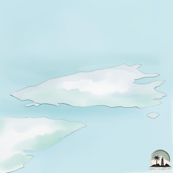
Geography and size of Sabine
Size: 149.7 km²
Coastline: 94.9 km
Ocean: Arctic Ocean
Sea: Greenland Sea
Continent: Europe
Sabine is a Large Island spanning 150 km² with a coastline of 95 km.
Archipel: –
Tectonic Plate: South America – A major plate covering the South American continent and part of the Atlantic Ocean, known for the Andes mountain range and significant seismic and volcanic activity.
The geographic heart of the island is pinpointed at these coordinates:
Latitude: 74.59692039 / Longitude: -18.9464681
Climate and weather of Sabine
Climate Zone: Polar
Climate Details: Tundra
Temperature: Cold
Climate Characteristics: The tundra climate features long, extremely cold winters and short, cool summers. Vegetation is limited to mosses, lichens, and small shrubs due to the low temperatures and short growing seasons. Biodiversity is low, but some specialized species thrive.
Topography and nature of Sabine
Timezone: UTC-03:00
Timezone places: America/Sao_Paulo
Max. Elevation: 693 m
Mean Elevation: 256 m
Vegetation: Sparse Vegetation
Tree Coverage: 76%
The mean elevation is 256 m. The highest elevation on the island reaches approximately 693 meters above sea level. The island is characterized by Plateau: Elevated flatlands rising sharply above the surrounding area, with a maximum elevation over 500 meters but a mean elevation less than 300 meters, forming unique highland areas on islands.
Dominating Vegetation: Sparse Vegetation
These regions have limited plant growth, typically due to extreme conditions like aridity or poor soils. Vegetation is scattered and consists of hardy plant species. Sabine has a tree cover of 76 %.
Vegetation: 4 vegetation zones – Diverse Island
Four distinct vegetation zones mark these islands as ecologically diverse. They might feature varied landscapes such as forests, beaches, grasslands, and rocky areas. Such diversity reflects the island’s complex ecological interactions and varied habitats, which can support a rich array of wildlife and plant species.
Infrastructure and Travelling to Sabine
Does the island have a public airport? no.
There is no public and scheduled airport on Sabine. The nearest airport is Ittoqqortoormiit Heliport, located 547 km away.
Does the island have a major port? no.
There are no major ports on Sabine. The closest major port is SIGLUFJORHURD, approximately 932 km away.
The mean population of Sabine is 0 per km². Sabine is Uninhabited. The island belongs to Denmark.
Continuing your journey, Lille Pendulum is the next notable island, situated merely km away.
Sabine Island Aug 2015


Denmark is classified as Developed region: nonG7: Developed economies outside of the Group of Seven, characterized by high income and advanced economic structures. The level of income is High income: OECD.
News – Latest Updates and Headlines from Sabine
Stay informed with the most recent news and important headlines from Sabine. Here’s a roundup of the latest developments.
Please note: The data used here has been primarily extracted from satellite readings. Deviations from exact values may occur, particularly regarding the height of elevations and population density. Land area and coastline measurements refer to average values at mean high tide.