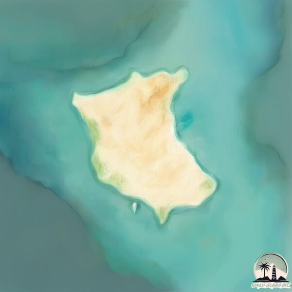
Welcome to Salutation Island, a Dry island in the Indian Ocean, part of the majestic Indian Ocean. This guide offers a comprehensive overview of what makes Salutation Island unique – from its geography and climate to its population, infrastructure, and beyond. Dive into the details:
Geography and size of Salutation Island
Size: 1.828 km²
Coastline: 6.5 km
Ocean: Indian Ocean
Sea: Indian Ocean
Continent: Oceania
Salutation Island is a Small Island spanning 1.8 km² with a coastline of 6.5 km.
Archipel: –
Tectonic Plate: Australia – A major tectonic plate covering Australia, New Zealand, and parts of the Indian and Pacific Oceans, known for its relative stability and occasional seismic activity.
The geographic heart of the island is pinpointed at these coordinates:
Latitude: -26.53916481 / Longitude: 113.76792283
Climate and weather of Salutation Island
Climate Zone: Dry
Climate Details: Hot Semi-Arid (Steppe) Climate
Temperature: Hot
Climate Characteristics: Features hot summers and mild to warm winters. Receives more rainfall than hot deserts but less than tropical savannas, leading to a somewhat more varied landscape.
Topography and nature of Salutation Island
Timezone: UTC+08:00
Timezone places: Australia/Perth
Max. Elevation: 8 m
Mean Elevation: 7 m
Vegetation: Shrubland
Tree Coverage: 30%
The mean elevation is 7 m. The highest elevation on the island reaches approximately 8 meters above sea level. The island is characterized by Plains: Flat, low-lying lands characterized by a maximum elevation of up to 200 meters. On islands, plains are typically coastal lowlands or central flat areas.
Dominating Vegetation: Shrubland
Dominated by shrubs and small bushes, these areas are typical in dry, rocky, or sandy environments, as well as in regions with poor soil fertility. Salutation Island has a tree cover of 30 %.
Vegetation: 4 vegetation zones – Diverse Island
Four distinct vegetation zones mark these islands as ecologically diverse. They might feature varied landscapes such as forests, beaches, grasslands, and rocky areas. Such diversity reflects the island’s complex ecological interactions and varied habitats, which can support a rich array of wildlife and plant species.
Infrastructure and Travelling to Salutation Island
Does the island have a public airport? no.
There is no public and scheduled airport on Salutation Island. The nearest airport is Shark Bay Airport, located 74 km away.
Does the island have a major port? no.
There are no major ports on Salutation Island. The closest major port is USELESS LOOP, approximately 64 km away.
The mean population of Salutation Island is 0 per km². Salutation Island is Uninhabited. The island belongs to Australia.
Continuing your journey, Faure is the next notable island, situated merely km away.
Salutation Island on Long Island Sound
Salutation is an exquisite deeded 85+ acre island on the North Shore of Long Island. The land was granted by King George I and ...Salutation Island on Long Island Sound
Salutation is an exquisite deeded 85+ acre island on the North Shore ...
Salutation is an exquisite deeded 85+ acre island on the North Shore of Long Island. The land was granted by King George I and ...
Epstein Island Boys?? Kodiyakredd and Flyysoulja as kids with Epstein??
Music from #Uppbeat (free for Creators!): Artist: Alex-Besss Song: ...
Music from #Uppbeat (free for Creators!): Artist: Alex-Besss Song: Critical-Evidence #epsteinisland #ps5 #playstation #xbox ...
How 2 download Watermark free Premium & Normal greeting cards from greetings island website for free
This video explains the possibility of downloading premium and normal ...
This video explains the possibility of downloading premium and normal greeting cards from greetings island website for free.
Sun Salutation Flow for Beginers | Nam Du Island | Kimmyogance
Let the ocean breeze and the rhythm of waves guide you through this ...
Let the ocean breeze and the rhythm of waves guide you through this gentle yoga.... #yogabeach #namduisland ...
YouTuber joined North Sentinel Island... 😳
Video Credits: Slam.Dunked Island: Vanuatu.
Video Credits: Slam.Dunked Island: Vanuatu.
Sun Salutation A #yoga #sunsalutation #jumpback
DYNAMIC ISLAND SECRET FEATURE 🔐
Okinawa Island:Japanese soldier surrender to US marine during ww2 #ww2 #history #military
The Battle of Okinawa was one of the most intense and brutal conflicts ...
The Battle of Okinawa was one of the most intense and brutal conflicts of World War II. This documentary explores how the U.S. ...
The BEST way to greet Shakra
shorts #gaming #hollowknightsilksong #hollowknight Check out more of ...
shorts #gaming #hollowknightsilksong #hollowknight Check out more of my Hollow Knight Silksong videos here!
Island Salutation
Provided to YouTube by Sequence Sequence Limited Island Salutation · ...
Provided to YouTube by Sequence Sequence Limited Island Salutation · Relax Chillout Lounge zZz Tropical Lounging Vibes zZz ...
Prince Edward Island Encyclopedia - Salutations
A list of odd and mostly offensive salutations used by Prince Edward ...
A list of odd and mostly offensive salutations used by Prince Edward Islanders. Like us on ...
How to create party invitations with Greetings Island App
Unlock the art of celebration with our step-by-step guide to creating ...
Unlock the art of celebration with our step-by-step guide to creating stunning party invitations! Choose from hundreds of designs ...
Wait A Minute... (Disventure Camp)
Wait A Minute... (Disventure Camp) Credit to @jakefansglobal link to ...
Wait A Minute... (Disventure Camp) Credit to @jakefansglobal link to their greeting is here ...
Never judge your island!! #animalcrossing #animalcrossingnewhorizons #nintendo #acnh
Beginner Yoga, Sun Salutation A with Kino on Waiheke Island, New Zealand
If you're looking for yoga videos that will show you the perfect way ...
If you're looking for yoga videos that will show you the perfect way for you to start your yoga journey then Kino MacGregor's yoga ...
Rhode Island: The REAL welcome greeting - Whose Line Is It Anyway?
Since I live in RI this is TOTALLY relatable to me. Haha! Instagram: ...
Since I live in RI this is TOTALLY relatable to me. Haha! Instagram: @Whose_Insta_Is_It_Anyway.
Total Drama Island: REAL vs CARTOON 💅 (Leshawna, Bridgette, Lindsay, & More)
Step into the world of Total Drama Island like never before! In this ...
Step into the world of Total Drama Island like never before! In this nostalgic episode, we reimagine these fan-favorite characters ...
how 2 say hi throughout the day🗣️🇩🇪 #german #easygerman #a1german #deutschlernen #learninggerman
How to make diwali greeting cards
Greetings Island : ...
Albanese and Solomon Islands leader share warm greeting in Fiji despite China tensions | ABC News
The Prime Minister, Anthony Albanese, has shared a warm embrace with ...
The Prime Minister, Anthony Albanese, has shared a warm embrace with his Solomon Islands counterpart on the sidelines of a ...
Enchantling Magical Sanctum - MSM Composer Tutorial #mysingingmonsterscomposer
Magical Sanctum - Enchantling - MSM Composer - Tutorial ...
Magical Sanctum - Enchantling - MSM Composer - Tutorial #mysingingmonsters #mysingingmonsterscomposer #viral ...
JYNXZI dances with goblins
Sunrise Sun Salutation I Gili Air Island I Sunrise Magic
Mind Body Balance Yoga, Gili Air. Early morning sunrise sun salutation ...
Mind Body Balance Yoga, Gili Air. Early morning sunrise sun salutation overlooking the volcano in Lombok.
#shorts Walking to Seakindly Foil School & Foil Park greeting masters of the sport
Kiawah Island Getaways Greeting
Australia is classified as Developed region: nonG7: Developed economies outside of the Group of Seven, characterized by high income and advanced economic structures. The level of income is High income: OECD.
News – Latest Updates and Headlines from Salutation Island
Stay informed with the most recent news and important headlines from Salutation Island. Here’s a roundup of the latest developments.
Loading...
Please note: The data used here has been primarily extracted from satellite readings. Deviations from exact values may occur, particularly regarding the height of elevations and population density. Land area and coastline measurements refer to average values at mean high tide.