San Pedro
Welcome to San Pedro, a Temperate island in the South Pacific Ocean, part of the majestic Pacific Ocean. This guide offers a comprehensive overview of what makes San Pedro unique – from its geography and climate to its population, infrastructure, and beyond. Dive into the details:
- Geography and Size: Explore the island’s size and location.
- Climate and Weather: Weather patterns and temperature.
- Topography and Nature: Uncover the natural wonders of the island.
- Infrastructure and Travelling: Insights on reaching, staying, and making the most of your visit.
- News and Headlines: Latest News.
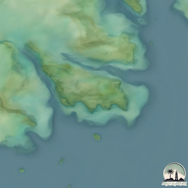
Geography and size of San Pedro
Size: 64.3 km²
Coastline: 53.9 km
Ocean: Pacific Ocean
Sea: South Pacific Ocean
Continent: South America
San Pedro is a Medium Island spanning 64 km² with a coastline of 54 km.
Archipel: –
Tectonic Plate: South America – A major plate covering the South American continent and part of the Atlantic Ocean, known for the Andes mountain range and significant seismic and volcanic activity.
The geographic heart of the island is pinpointed at these coordinates:
Latitude: -43.35579923 / Longitude: -73.73446106
Climate and weather of San Pedro
Climate Zone: Temperate
Climate Details: Temperate Oceanic Climate
Temperature: Warm Summer
Climate Characteristics: Known for its moderate year-round temperatures with ample rainfall and no dry season. Warm summers are characteristic.
Topography and nature of San Pedro
Timezone: UTC-04:00
Timezone places: America/La_Paz
Max. Elevation: 517 m
Mean Elevation: 160 m
Vegetation: Evergreen Broadleaf Forest
Tree Coverage: 98%
The mean elevation is 160 m. The highest elevation on the island reaches approximately 517 meters above sea level. The island is characterized by Plateau: Elevated flatlands rising sharply above the surrounding area, with a maximum elevation over 500 meters but a mean elevation less than 300 meters, forming unique highland areas on islands.
Dominating Vegetation: Evergreen Broadleaf Forest
Characterized by dense, lush canopies of broadleaf trees that retain their leaves year-round. These forests are typically found in tropical and subtropical regions and are known for their high biodiversity. San Pedro has a tree cover of 98 %.
Vegetation: 4 vegetation zones – Diverse Island
Four distinct vegetation zones mark these islands as ecologically diverse. They might feature varied landscapes such as forests, beaches, grasslands, and rocky areas. Such diversity reflects the island’s complex ecological interactions and varied habitats, which can support a rich array of wildlife and plant species.
Infrastructure and Travelling to San Pedro
Does the island have a public airport? no.
There is no public and scheduled airport on San Pedro. The nearest airport is Mocopulli Airport, located 108 km away.
Does the island have a major port? no.
There are no major ports on San Pedro. The closest major port is PUERTO CASTRO, approximately 92 km away.
The mean population of San Pedro is 15 per km². San Pedro is Gently Populated. The island belongs to Chile.
The name of the island resonates across different cultures and languages. Here is how it is known around the world: Arabic: جزيرة شيلوي; German: Chiloé; Spanish: Isla Grande de Chiloé; French: île de Chiloé; Portuguese: Ilha Grande de Chiloé; Russian: Чилоэ; Chinese: 奇洛埃岛
Continuing your journey, Quenay is the next notable island, situated merely km away.
San Pedro Belize Travel Guide: 15 BEST Things To Do In San Pedro Ambergris Caye


Chile is classified as Emerging region: G20: Group of Twenty – Major economies comprising both developed and emerging countries, representing the world’s largest economies. The level of income is Upper middle income.
News – Latest Updates and Headlines from San Pedro
Stay informed with the most recent news and important headlines from San Pedro. Here’s a roundup of the latest developments.
Please note: The data used here has been primarily extracted from satellite readings. Deviations from exact values may occur, particularly regarding the height of elevations and population density. Land area and coastline measurements refer to average values at mean high tide.