Welcome to Sanibel, a Tropical island in the Gulf of Mexico, part of the majestic Atlantic Ocean. This guide offers a comprehensive overview of what makes Sanibel unique – from its geography and climate to its population, infrastructure, and beyond. Dive into the details:
Geography and size of Sanibel
Size: 54.6 km²
Coastline: 91.1 km
Ocean: Atlantic Ocean
Sea: Gulf of Mexico
Continent: North America
Sanibel is a Medium Island spanning 55 km² with a coastline of 91 km.
Archipel: –
Tectonic Plate: North America – Covers North America and parts of the Atlantic and Arctic Oceans, characterized by diverse geological features and varying levels of seismic activity.
The geographic heart of the island is pinpointed at these coordinates:
Latitude: 26.45783457 / Longitude: -82.11031157
Climate and weather of Sanibel
Climate Zone: Tropical
Climate Details: Tropical Savanna, Wet
Temperature: Hot
Climate Characteristics: Defined by distinct wet and dry seasons with high temperatures year-round. Pronounced rainfall occurs during the wet season, while the dry season is marked by drought.
Topography and nature of Sanibel
Timezone: UTC-05:00
Timezone places: America/New_York
Max. Elevation: 9 m
Mean Elevation: 4 m
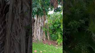
Vegetation: Wetland
Tree Coverage: 70%
The mean elevation is 4 m. The highest elevation on the island reaches approximately 9 meters above sea level. The island is characterized by Plains: Flat, low-lying lands characterized by a maximum elevation of up to 200 meters. On islands, plains are typically coastal lowlands or central flat areas.
Dominating Vegetation: Wetland
These areas are saturated with water, either permanently or seasonally, and support aquatic plants. Wetlands are important for biodiversity and water filtration. Sanibel has a tree cover of 70 %.
Vegetation: 12 vegetation zones – Exceptionally Diverse Island
Islands with more than ten vegetation zones are among the most ecologically rich and varied in the world. These islands are akin to miniature continents, boasting an incredible array of ecosystems. The sheer range of habitats, from high peaks to deep valleys, rainforests to deserts, creates a mosaic of life that is unparalleled. They are crucial for conservation and ecological studies.
Infrastructure and Travelling to Sanibel
Does the island have a public airport? no.
There is no public and scheduled airport on Sanibel. The nearest airport is Southwest Florida International Airport, located 30 km away.
Does the island have a major port? no.
There are no major ports on Sanibel. The closest major port is BOCA GRANDE, approximately 22 km away.
The mean population of Sanibel is 189 per km². Sanibel is Moderately Inhabited. The island belongs to United States of America.
Continuing your journey, Cayo Costa is the next notable island, situated merely km away.
Sanibel Island Florida: Best Things To Do In Sanibel Island Florida
Sanibel Island Florida Welcome to Sanibel Island Florida—a paradise of white sandy beaches, world-class shelling, and ...Sanibel Island Florida: Best Things To Do In Sanibel Island Florida
Sanibel Island Florida Welcome to Sanibel Island Florida—a paradise of ...
Sanibel Island Florida Welcome to Sanibel Island Florida—a paradise of white sandy beaches, world-class shelling, and ...
Shelling Sanibel a Week After a Storm, Post Hurricane Milton
What mid beach on Sanibel Island left us a week after Hurricane Milton ...
What mid beach on Sanibel Island left us a week after Hurricane Milton hit about 70 miles north of this area. Even though it was a ...
The Truth About Visiting Sanibel and Captiva in 2025
Join Chad Gallivanter on a journey across Sanibel and Captiva—two of ...
Join Chad Gallivanter on a journey across Sanibel and Captiva—two of Florida's most beloved barrier islands still finding their ...
Sanibel sees busiest start to season since Hurricane Ian
More than three years after Hurricane Ian, Sanibel Island is seeing a ...
More than three years after Hurricane Ian, Sanibel Island is seeing a surge of tourists, a jump in beach revenue and fewer ...
Sanibel Island Florida Travel Guide: 16 BEST Things To Do In Sanibel Island
Imagine stepping off the plane, texting “I made it,” pulling up ...
Imagine stepping off the plane, texting “I made it,” pulling up directions, booking a ride, and heading straight into the adventure ...
Sanibel Island’s Store | Untold Stories
Sanibel Island's Store traces the journey of a family, a small ...
Sanibel Island's Store traces the journey of a family, a small business, and an island determined to rebuild and thrive after ...
Sanibel Island, Florida, Where to Go to Find the BEST Shells?
Sanibel Island is one of the best places in the world to look for ...
Sanibel Island is one of the best places in the world to look for seashells. Perched on a plateau that stretches out into the Gulf of ...
Hurricane Ian: Witnessing the aftermath on Sanibel Island and Florida’s southwest coast | 60 Minutes
Bill Whitaker travels to the Florida shoreline where Hurricane Ian ...
Bill Whitaker travels to the Florida shoreline where Hurricane Ian made landfall as a Category 4 storm. #60Minutes #News ...
Come Shelling for the Day with us on Sanibel Island- Look What we Found!!
Top Things to Do in Sanibel Island Florida | Beaches, Shelling and More!
Planning a trip to Sanibel Island, Florida? In this guide, we'll show ...
Planning a trip to Sanibel Island, Florida? In this guide, we'll show you the best things to do in Sanibel, from exploring the best ...
Top 10 Best Beachfront Hotels in Sanibel Island, Florida, USA
Top 10 Best Beachfront Hotels in Sanibel Island, Florida, USA ▻ Please ...
Top 10 Best Beachfront Hotels in Sanibel Island, Florida, USA ▻ Please subscribe!
https://goo.gl/AuK9gR ❖ Island Inn 3-star ...
Sanibel Island: Timelapse of Hurricane Ian
This is a time lapse video from the rooftop of our condominium on ...
This is a time lapse video from the rooftop of our condominium on Sanibel Island. It was shot a day before (and day of) Hurricane ...
Sanibel Island Cut Off From Mainland Florida Due To Hurricane Ian
Hurricane Ian's wind and storm surge tore Sanibel Island to shreds, ...
Hurricane Ian's wind and storm surge tore Sanibel Island to shreds, prompting a massive rescue effort. NBC News' Morgan ...
Sanibel Island Florida Driving Tour
Join us as we take a scenic tour of this beautiful barrier island ...
Join us as we take a scenic tour of this beautiful barrier island located on Florida's Gulf Coast. We'll cruise along the island's main ...
Bailey's General Store is Back on Sanibel Island 3 Years After Hurricane Ian
Bailey's General Store has been a cherished piece of Sanibel Island's ...
Bailey's General Store has been a cherished piece of Sanibel Island's history since 1899. In the wake of destruction from ...
Blind Pass, where Sanibel Island Meets Captiva Island #florida #floridabeach #sanibelisland
This is the pass between Sanibel Island and Captiva island here in ...
This is the pass between Sanibel Island and Captiva island here in southwest Florida. Paradise! 🏝️Castaway Ship Store:🏝️ ...
Sanibel Island, Florida Building Back Following 3 Disastrous Hurricanes
SANIBEL CHARM: Hurricanes Ian, Helene and Milton caused millions of ...
SANIBEL CHARM: Hurricanes Ian, Helene and Milton caused millions of dollars in damage to Sanibel Island, ripping away some ...
Sanibel Island and Captiva Island, Florida - Things to Do and See When You Visit
Blind Pass Update: Sand From Captiva Renourishment Filling the Pass!
Blind Pass is one of the most dynamic coastal areas between Sanibel ...
Blind Pass is one of the most dynamic coastal areas between Sanibel and Captiva Islands, and recent Captiva beach ...
TOP Waterfront Restaurants and Bars on Sanibel Island - DOWNLOAD the FREE Waterfront Trail PASSPORT
Sanibel Island's road to recovery after hurricanes
Sanibel Island is working to rebuild stronger and more resilient after ...
Sanibel Island is working to rebuild stronger and more resilient after years of devastating hurricanes.
Looking for seashells at sunrise. Sanibel Island post Hurricane Milton.
Looking for seashells. It sounds so peaceful and relaxing - and it is! ...
Looking for seashells. It sounds so peaceful and relaxing - and it is! I'll take you on a tour of Lighthouse Beach on Sanibel island ...
A Sanibel Island Secret 🤫
Perfect Itinerary for Sanibel Island, Florida 😍 #florida #sanibel #MyFortMyers @FtMyersSanibel
Flying Over Sanibel Island Causeway in 4K
Experience breathtaking aerial views of Sanibel Island and the iconic ...
Experience breathtaking aerial views of Sanibel Island and the iconic Sanibel Causeway in stunning 4K Ultra HD. This drone ...
United States of America is classified as Developed region: G7: Group of Seven – Major advanced economies, including Canada, France, Germany, Italy, Japan, the United Kingdom, and the United States. The level of income is High income: OECD.
News – Latest Updates and Headlines from Sanibel
Stay informed with the most recent news and important headlines from Sanibel. Here’s a roundup of the latest developments.
Loading...
Please note: The data used here has been primarily extracted from satellite readings. Deviations from exact values may occur, particularly regarding the height of elevations and population density. Land area and coastline measurements refer to average values at mean high tide.