Welcome to Santiago, a Tropical island in the South China Sea, part of the majestic Pacific Ocean. This guide offers a comprehensive overview of what makes Santiago unique – from its geography and climate to its population, infrastructure, and beyond. Dive into the details:
Geography and size of Santiago
Size: 20.5 km²
Coastline: 31.1 km
Ocean: Pacific Ocean
Sea: South China Sea
Continent: Asia
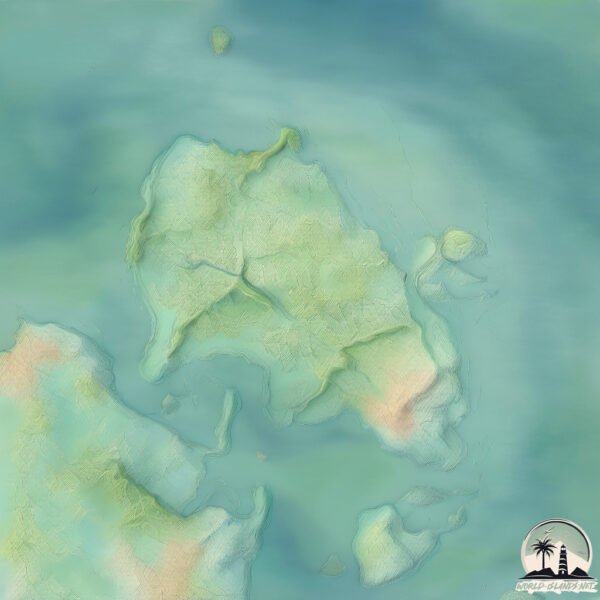
Santiago is a Medium Island spanning 20 km² with a coastline of 31 km.
Archipel: Malay Archipelago – The world’s largest archipelago, located between mainland Southeast Asia and Australia, known for its immense biodiversity and cultural diversity.
Tectonic Plate: Eurasia – One of the world’s largest tectonic plates, the Eurasian Plate covers a significant portion of Europe and Asia. It’s characterized by diverse geological features, including the Ural Mountains, the European Plain, and the Himalayas formed from its collision with the Indian Plate.
The geographic heart of the island is pinpointed at these coordinates:
Latitude: 16.39891379 / Longitude: 119.93464058
Climate and weather of Santiago
Climate Zone: Tropical
Climate Details: Tropical Monsoon Climate
Temperature: Hot
Climate Characteristics: Characterized by heavy rainfall, high humidity, and uniformly high temperatures, but with a distinct short dry season. It features a seasonal reversal of prevailing wind directions.
Topography and nature of Santiago
Timezone: UTC+08:00
Timezone places: Australia/Perth
Max. Elevation: 31 m
Mean Elevation: 14 m
Vegetation: Agricultural Mosaic
Tree Coverage: 46%
The mean elevation is 14 m. The highest elevation on the island reaches approximately 31 meters above sea level. The island is characterized by Plains: Flat, low-lying lands characterized by a maximum elevation of up to 200 meters. On islands, plains are typically coastal lowlands or central flat areas.
Dominating Vegetation: Agricultural Mosaic
A mix of cropland and natural vegetation, often seen in rural landscapes where agricultural fields are interspersed with patches of natural habitats. Santiago has a tree cover of 46 %.
Vegetation: 8 vegetation zones – Very Highly Diverse Island
Islands in this range are ecological powerhouses, showcasing a wide array of vegetation zones. Each zone, from lush rainforests to arid scrublands, coastal mangroves to mountainous regions, contributes to a complex and interdependent ecosystem. These islands are often hotspots of biodiversity, supporting numerous species and intricate ecological processes.
Infrastructure and Travelling to Santiago
Does the island have a public airport? no.
There is no public and scheduled airport on Santiago. The nearest airport is San Fernando Airport, located 44 km away.
Does the island have a major port? no.
There are no major ports on Santiago. The closest major port is SAN FERNANDO HARBOR, approximately 47 km away.
The mean population of Santiago is 990 per km². Santiago is Densely Populated. The island belongs to Philippines.
Continuing your journey, Cabarruyan is the next notable island, situated merely km away.
Shocking: Inside Praia (Santiago Island) Cape Verde
Buy my travel guide here: ...
Cape Verde Santiago Island Is The PERFECT Eco Destination! | Cape Verde Travel Guide in Holidays
😔 My Biggest Regret in Cape Verde? Skipping Santiago Island (Praia) 🇨🇻
Cape Verde gave me some of the best memories of my travels but if I ...
Cape Verde gave me some of the best memories of my travels but if I could change one thing, it would be this: not making the trip ...
Buccaneers Cove on Santiago Island - The Galápagos Islands, Ecuador, South America
In 2019 I spent 8 Days on an amazing Boat Tour Of The Galápagos ...
In 2019 I spent 8 Days on an amazing Boat Tour Of The Galápagos Islands. Here is a selection of short video diaries of my trip.
Cabo Verde Holidays: Santiago Island, the Heart of Cabo Verde
Discover Santiago, Cape Verde's largest island, where the vibrant city ...
Discover Santiago, Cape Verde's largest island, where the vibrant city of Praia meets the rich history of Cidade Velha, a UNESCO ...
Tulay na magkokonekta sa Santiago Island at Bolinao Town Proper, sisimulan ng itayo
Tulay na magkokonekta sa Santiago Island at Bolinao Town Proper, ...
Tulay na magkokonekta sa Santiago Island at Bolinao Town Proper, sisimulan ng itayo.
Cape Verde tour Guide #The best trail on santiago island
A trilha serra malagueta para Hortelã passando por Gongon é sem dúvida ...
A trilha serra malagueta para Hortelã passando por Gongon é sem dúvida a mais procurada na ilha de Santiago, para lem de ser ...
Exploring Santiago Island in Cape Verde 🇨🇻 #santiago #capeverde #praia #travelvlog
Santiago Island 📍Bolinao Pangasinan
Top 10 Best Places to Visit in Santiago 😍 | Cape Verde 🇨🇻 ( Cabo Verde)
Santiago island and Praia Cabo Verde / Cape Verde
This is Santiago island and Praia in Cabo Verde If you want to know ...
This is Santiago island and Praia in Cabo Verde If you want to know about this island more , just give comment to me Esta é a ilha ...
Discover Santiago Island - Cabo Verde
Discover the beauty of Santiago Cabo Verde (Cape Verde) with your ...
Discover the beauty of Santiago Cabo Verde (Cape Verde) with your guide, Silvio Brito. A native of the island, Silvio is ...
Cape Verde Unplugged - Santiago: This is Africa
Welcome to Cape Verde as you've never seen it before! Beyond the ...
Welcome to Cape Verde as you've never seen it before! Beyond the resorts of Sal and Boavista lies the rest of the country of Cape ...
Santiago Island Lava Flow | Galápagos Islands | Lindblad Expeditions
The lava flow of Santiago Island and its wildlife provides an ...
The lava flow of Santiago Island and its wildlife provides an informative snapshot of how evolution works. Video by Andrés Cruz ...
Galapagos Remote Islands: Exploring Marchena & Santiago
In this travel video, we'll journey by yacht to the remote Galapagos ...
In this travel video, we'll journey by yacht to the remote Galapagos Islands of Marchena and Santiago. This vlog shares the ...
Santiago Island, Cabo Verde 🇨🇻
The Pearl of Africa: Cabo Verde, Santiago 🇨🇻 (a real and wild experience)
Mind-blowing views, raw places, visiting local towns and villages and ...
Mind-blowing views, raw places, visiting local towns and villages and more - this is a documentary of trip to Santiago, Cabo Verde.
Tarrafal, Santiago Island - Cabo Verde
Tarrafal, Santiago Island - Cabo Verde Shooting with GoPro Hero 7: ...
Santiago Island #sea #beach
Island-hopping in Galápagos: Santiago Island and Floreana Island
Andy Duckworth island hops in Galápagos, and encounters blue-footed ...
Andy Duckworth island hops in Galápagos, and encounters blue-footed boobies, sea lions, marine iguanas, an oystercatcher ...
Cape Verde - Things you never knew
3 things you didn't know about #capeverde #countries #europe #asia ...
3 things you didn't know about #capeverde #countries #europe #asia #america #europe #cambodianews ...
Santiago Island in Bolinao Pangasinan 🇵🇭 #philippines #pangasinan #bolinao
A lovely Island in Bolinao Pangasinan. Called Santiago Island... will ...
A lovely Island in Bolinao Pangasinan. Called Santiago Island... will soon be connected via bridge from main town...
The iconic Tarrafal Beach, Santiago island, Cabo Verde (Cape Verde)
All images captured with-
https://amzn.to/2YIvlcW Please subscribe and don't forget to click the bell to see my next video!
🐄🌴 Discover how feral cattle turned Santiago Island into an unexpected drama in the Galápagos.
"On Santiago Island in the Galápagos, cattle brought by settlers in ...
"On Santiago Island in the Galápagos, cattle brought by settlers in the 1800s went feral, reshaping the island's ecosystem.
Philippines is classified as Emerging region: G20: Group of Twenty – Major economies comprising both developed and emerging countries, representing the world’s largest economies. The level of income is Lower middle income.
News – Latest Updates and Headlines from Santiago
Stay informed with the most recent news and important headlines from Santiago. Here’s a roundup of the latest developments.
Loading...
Please note: The data used here has been primarily extracted from satellite readings. Deviations from exact values may occur, particularly regarding the height of elevations and population density. Land area and coastline measurements refer to average values at mean high tide.