Sea Cow Island
Welcome to Sea Cow Island, a Tropical island in the Indian Ocean, part of the majestic Indian Ocean. This guide offers a comprehensive overview of what makes Sea Cow Island unique – from its geography and climate to its population, infrastructure, and beyond. Dive into the details:
- Geography and Size: Explore the island’s size and location.
- Climate and Weather: Weather patterns and temperature.
- Topography and Nature: Uncover the natural wonders of the island.
- Infrastructure and Travelling: Insights on reaching, staying, and making the most of your visit.
- News and Headlines: Latest News.
Geography and size of Sea Cow Island
Size: 0.246 km²
Coastline: 2 km
Ocean: Indian Ocean
Sea: Indian Ocean
Continent: Seven seas (open ocean)
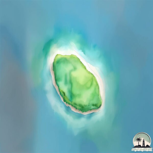
Sea Cow Island is a Tiny Island spanning 0.246 km² with a coastline of 2 km.
Archipel: Chagos Archipelago – A group of atolls in the Indian Ocean, known for the Diego Garcia military base and their rich marine biodiversity.
Tectonic Plate: India – A major tectonic plate that initially moved northward at a rapid pace before colliding with the Eurasian Plate. This collision is responsible for the uplift of the Himalayas and the Tibetan Plateau.
The geographic heart of the island is pinpointed at these coordinates:
Latitude: -6.23506852 / Longitude: 71.29456374
Climate and weather of Sea Cow Island
Climate Zone: Tropical
Climate Details: Tropical Rainforest Climate
Temperature: Hot
Climate Characteristics: This climate is typified by heavy rainfall throughout the year, high humidity, and consistently high temperatures, leading to lush rainforests and rich biodiversity. Seasonal temperature variations are minimal.
Topography and nature of Sea Cow Island
Timezone: UTC+06:00
Timezone places: Indian/Chagos
Max. Elevation: 0 m
Mean Elevation: -1 m
Vegetation: Open Woodland
Tree Coverage: 95%
The mean elevation is -1 m. The highest elevation on the island reaches approximately 0 meters above sea level. The island is characterized by Plains: Flat, low-lying lands characterized by a maximum elevation of up to 200 meters. On islands, plains are typically coastal lowlands or central flat areas.
Dominating Vegetation: Open Woodland
Characterized by sparsely distributed trees with open canopy allowing sunlight to penetrate, supporting grasses and shrubs underneath. Often found in drier or transitional environments. Sea Cow Island has a tree cover of 95 %.
Vegetation: 1 vegetation zones – Minimal Diversity Island
These islands exhibit the most basic level of ecological diversity, often characterized by a single dominant vegetation type. This could be due to extreme environmental conditions, limited land area, or significant human impact. They represent unique ecosystems where specific species have adapted to thrive in these singular environments.
Infrastructure and Travelling to Sea Cow Island
Does the island have a public airport? no.
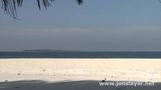
There is no public and scheduled airport on Sea Cow Island. The nearest airport is Gan International Airport, located 649 km away.
Does the island have a major port? no.
There are no major ports on Sea Cow Island. The closest major port is DIEGO GARCIA, approximately 179 km away.
The mean population of Sea Cow Island is per km². Sea Cow Island is . The island belongs to United Kingdom.
Continuing your journey, Agalega South is the next notable island, situated merely km away.
What is HIDDEN on this MYSTERY Sea Cow Island?


United Kingdom is classified as Developed region: G7: Group of Seven – Major advanced economies, including Canada, France, Germany, Italy, Japan, the United Kingdom, and the United States. The level of income is High income: OECD.
News – Latest Updates and Headlines from Sea Cow Island
Stay informed with the most recent news and important headlines from Sea Cow Island. Here’s a roundup of the latest developments.
Please note: The data used here has been primarily extracted from satellite readings. Deviations from exact values may occur, particularly regarding the height of elevations and population density. Land area and coastline measurements refer to average values at mean high tide.