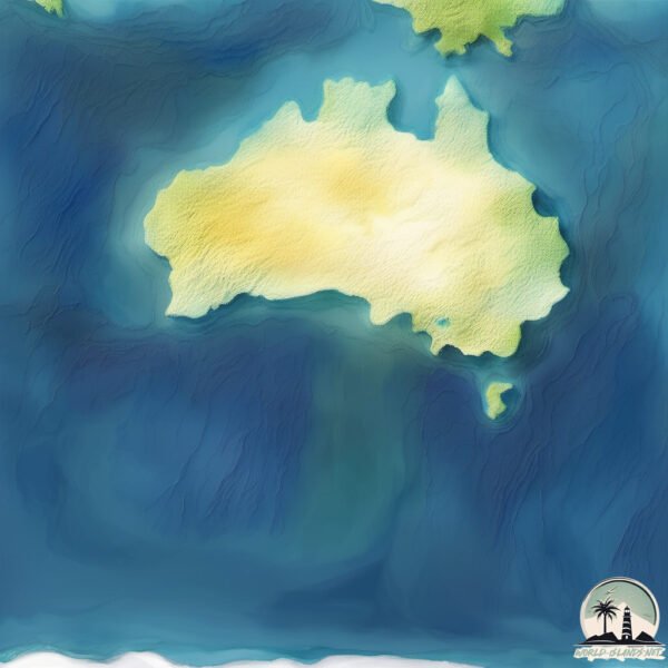
Welcome to Seal Island, a Temperate island in the Great Australian Bight, part of the majestic Pacific Ocean. This guide offers a comprehensive overview of what makes Seal Island unique – from its geography and climate to its population, infrastructure, and beyond. Dive into the details:
Geography and size of Seal Island
Size: 0.21 km²
Coastline: 2.6 km
Ocean: Pacific Ocean
Sea: Great Australian Bight
Continent: Oceania
Seal Island is a Tiny Island spanning 0.21 km² with a coastline of 2.6 km.
Archipel: –
Tectonic Plate: Australia – A major tectonic plate covering Australia, New Zealand, and parts of the Indian and Pacific Oceans, known for its relative stability and occasional seismic activity.
The geographic heart of the island is pinpointed at these coordinates:
Latitude: -37.29394818 / Longitude: 138.18055
Climate and weather of Seal Island
Climate Zone: Temperate
Climate Details: Temperate Oceanic Climate
Temperature: Warm Summer
Climate Characteristics: Known for its moderate year-round temperatures with ample rainfall and no dry season. Warm summers are characteristic.
Topography and nature of Seal Island
Timezone: UTC+10:00
Timezone places: Australia/Sydney
Max. Elevation: 0 m
Mean Elevation: -3 m
Vegetation: Evergreen Needleleaf Forest
Tree Coverage: 100%
The mean elevation is -3 m. The highest elevation on the island reaches approximately 0 meters above sea level. The island is characterized by Plains: Flat, low-lying lands characterized by a maximum elevation of up to 200 meters. On islands, plains are typically coastal lowlands or central flat areas.
Dominating Vegetation: Evergreen Needleleaf Forest
Dominated by evergreen coniferous trees such as pines and firs, which retain their needle-like leaves throughout the year. These forests are often found in cooler climates. Seal Island has a tree cover of 100 %.
Vegetation: 1 vegetation zones – Minimal Diversity Island
These islands exhibit the most basic level of ecological diversity, often characterized by a single dominant vegetation type. This could be due to extreme environmental conditions, limited land area, or significant human impact. They represent unique ecosystems where specific species have adapted to thrive in these singular environments.
Infrastructure and Travelling to Seal Island
Does the island have a public airport? no.
There is no public and scheduled airport on Seal Island. The nearest airport is Albany Airport, located 23 km away.
Does the island have a major port? no.
There are no major ports on Seal Island. The closest major port is ALBANY, approximately 11 km away.
The mean population of Seal Island is 35 per km². Seal Island is Gently Populated. The island belongs to Australia.
Continuing your journey, Sand is the next notable island, situated merely km away.
Seal Island Lighthouse - The Graveyard Sentinel
If you enjoyed this video, please consider joining my Patreon to help create more videos like this!Seal Island Lighthouse - The Graveyard Sentinel
If you enjoyed this video, please consider joining my Patreon to help ...
If you enjoyed this video, please consider joining my Patreon to help create more videos like this!
Seal Island: 75,000 Seals! 😱
Seal Island: Witness the Incredible Gathering of 75000 Seals! Discover ...
Seal Island: Witness the Incredible Gathering of 75000 Seals! Discover the astonishing sight of Seal Island, home to an incredible ...
Seal Island (1948)
Oscar Winner for Live Action Short.
Oscar Winner for Live Action Short.
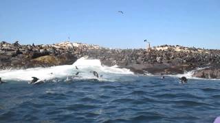
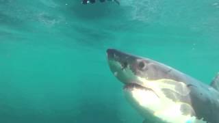
Breaching Great White sharks, Seal Island South Africa
Seal Island is world famous for the most intense predator/prey ...
Seal Island is world famous for the most intense predator/prey interactions with great white sharks and Cape fur seals (Peak ...
48 Hours on Asia's Women Island (no men here)
How to Travel Community: ...
Seal island charter from Hout Bay, South Africa
Seal Island and False Bay Feeding Frenzy!
nomadicNewmans.
nomadicNewmans.
Great White Shark Legend - Seal Island and Breach clip
This clip from the documentary Great White Shark Legend discusses the ...
This clip from the documentary Great White Shark Legend discusses the location and uniqueness of Seal Island, False Bay and ...
Seal Island Cruise REVEALED: South Africa's Wild Beauty Exposed!
blimages2 Join us on an unforgettable Seal Island cruise in Hout Bay, ...
blimages2 Join us on an unforgettable Seal Island cruise in Hout Bay, South Africa! Witness the untamed beauty of the Cape ...
Great White Prowling Around Seal Island
Great White Prowling Around Seal Island . . FREE MOSSEL BAY GREAT ...
Great White Prowling Around Seal Island . . FREE MOSSEL BAY GREAT WHITE SHARK INFO PACK DOWNLOADABLE ...
amazing seal Island 🤩😱 #shorts
amazing seal Island #shorts your queries: seal island island seals ...
amazing seal Island #shorts your queries: seal island island seals diving with seals farne islands seal island tours islands ...
Fur Seals Overcome Extinction On ‘Resurrection Island’ – Ep. 1 | Wildlife: Resurrection Island
It's a life of extremes for Antarctic fur seals. Bulls fight to the ...
It's a life of extremes for Antarctic fur seals. Bulls fight to the death for breeding rights, while seal moms work to raise their adorable ...
Seal Island – The Shark Capital #travel #facts #southafrica #shark #nature #naturelovers #ocean
travel #traveller #travelling #travelblogger #southafricans ...
travel #traveller #travelling #travelblogger #southafricans #southafricatravel #proudlysouthafrican #travelgram ...
Great Whites In Full Hunting Mode At Seal Island | SHARK WEEK 2016
Air Jaws: Night Stalker Full moon at Seal Island, great white sharks ...
Air Jaws: Night Stalker Full moon at Seal Island, great white sharks are waiting for the seals to leave the rock for an offshore ...
#shorts Seal island, capetown #youtubeshort
Shark cage diving, Seal Island, South Africa
Join Apex Shark Expeditions for an intimate and educational experience ...
Join Apex Shark Expeditions for an intimate and educational experience to observe and cage dive with the Great White sharks of ...
Visited  seal Island in Cape Town #traveldestinations #travel #capetown
Seal Island Has Over 12,000 Seals Per Acre
Seal Island Western Australia in 4k - DJI Mini 2
dji #drone #mini2 #westernaustralia #ocean #australia #fpv #ocean #4k.
dji #drone #mini2 #westernaustralia #ocean #australia #fpv #ocean #4k.
SHARKS at the famous Seal Island! | South Africa | Cape Town | Shark Cage Diving at Seal Island
thefiestalife #sharkcagediving #apexsharkexpeditions #capetown ...
thefiestalife #sharkcagediving #apexsharkexpeditions #capetown #southafrica Being locked in a cage with sharks swimming ...
Seal Island Cape Town South Africa 🇿🇦
Seal island, South Africa
Great White Sharks At Seal Island! Mossel Bay Great White Shark Update 06/05/2023
Great White Sharks At Seal Island! Mossel Bay Great White Shark Update ...
Great White Sharks At Seal Island! Mossel Bay Great White Shark Update 06/05/2023 . . FREE MOSSEL BAY GREAT WHITE ...
Great White Shark In Hunting Mode At Seal Island
Great White Shark In Hunting Mode At Seal Island . . FREE MOSSEL BAY ...
Great White Shark In Hunting Mode At Seal Island . . FREE MOSSEL BAY GREAT WHITE SHARK INFO PACK DOWNLOADABLE ...
Australia is classified as Developed region: nonG7: Developed economies outside of the Group of Seven, characterized by high income and advanced economic structures. The level of income is High income: OECD.
News – Latest Updates and Headlines from Seal Island
Stay informed with the most recent news and important headlines from Seal Island. Here’s a roundup of the latest developments.
Loading...
Please note: The data used here has been primarily extracted from satellite readings. Deviations from exact values may occur, particularly regarding the height of elevations and population density. Land area and coastline measurements refer to average values at mean high tide.