Welcome to Seil’, a Dry island in the Red Sea, part of the majestic Indian Ocean. This guide offers a comprehensive overview of what makes Seil’ unique – from its geography and climate to its population, infrastructure, and beyond. Dive into the details:
Geography and size of Seil’
Size: 0.18 km²
Coastline: 1.7 km
Ocean: Indian Ocean
Sea: Red Sea
Continent: Africa
Seil’ is a Tiny Island spanning 0.18 km² with a coastline of 1.7 km.
Archipel: –
Tectonic Plate: Arabia – A major tectonic plate covering the Arabian Peninsula and parts of the Middle East. The plate is primarily continental and known for its collision with the Eurasian Plate, leading to the uplift of the Zagros Mountains.
The geographic heart of the island is pinpointed at these coordinates:
Latitude: 14.84045564 / Longitude: 40.84327805
Climate and weather of Seil’
Climate Zone: Dry
Climate Details: Hot Deserts Climate
Temperature: Hot
Climate Characteristics: Dominated by extremely hot temperatures, this climate is marked by minimal rainfall and barren landscapes. Nights often experience drastic temperature drops.
Topography and nature of Seil’
Timezone: UTC+03:00
Timezone places: Asia/Riyadh
Max. Elevation: -4 m
Mean Elevation: -4 m
Vegetation: Shrubland
Tree Coverage: 69%
The mean elevation is -4 m. Remarkably, this unique island barely emerges above the sea level, showcasing nature’s fascinating interplay with the ocean. The island is characterized by Plains: Flat, low-lying lands characterized by a maximum elevation of up to 200 meters. On islands, plains are typically coastal lowlands or central flat areas.
Dominating Vegetation: Shrubland
Dominated by shrubs and small bushes, these areas are typical in dry, rocky, or sandy environments, as well as in regions with poor soil fertility. Seil’ has a tree cover of 69 %.
Vegetation: 1 vegetation zones – Minimal Diversity Island
These islands exhibit the most basic level of ecological diversity, often characterized by a single dominant vegetation type. This could be due to extreme environmental conditions, limited land area, or significant human impact. They represent unique ecosystems where specific species have adapted to thrive in these singular environments.
Infrastructure and Travelling to Seil’
Does the island have a public airport? no.
There is no public and scheduled airport on Seil’. The nearest airport is Massawa International Airport, located 188 km away.
Does the island have a major port? no.
There are no major ports on Seil’. The closest major port is MITSIWA HARBOR, approximately 175 km away.
The mean population of Seil’ is 5 per km². Seil’ is Gently Populated. The island belongs to Eritrea.
Continuing your journey, Beka’e is the next notable island, situated merely km away.
Secret Hebrides - The Slate Islands! (A Cultural Travel Guide to Seil, Luing, Easedale & beyond)
On the west coast of Scotland, Just 20 minutes south of Oban you cross an ancient bridge and enter into a different world, the ...Secret Hebrides - The Slate Islands! (A Cultural Travel Guide to Seil, Luing, Easedale & beyond)
On the west coast of Scotland, Just 20 minutes south of Oban you cross ...
On the west coast of Scotland, Just 20 minutes south of Oban you cross an ancient bridge and enter into a different world, the ...
You NEED To Visit Isle Of Seil - If Your Going To Oban
In today's vlog, we visit the beautiful Isle of Seil which is located ...
In today's vlog, we visit the beautiful Isle of Seil which is located 7 miles southwest of Oban and is one of the most scenic places in ...
Isles of Seil and Easdale, Scotland - two slate islands
We cross the 'Bridge over the Atlantic' to the Isle of Seil, 12 miles ...
We cross the 'Bridge over the Atlantic' to the Isle of Seil, 12 miles south of Oban, western Scotland, visiting Ellenabeich, a former ...
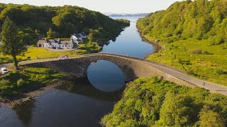
Bridge over the Atlantic Isle of Seil
The Isle of Seil. A short distance down the coast from Oban on the ...
The Isle of Seil. A short distance down the coast from Oban on the west coast of Scotland. The Isle of Seil was onetime home of ...
Trip to Seil Island - Westies Tour Scotland 2017 - Day 3
A trip to Seil Island, the Oyster Bar and a drive through Oban.
A trip to Seil Island, the Oyster Bar and a drive through Oban.
Seil Island Circumnavigation Oban Feb 2023. Day 3
Sea Kayaking: Day three from our long weekend kayaking around the Oban ...
Sea Kayaking: Day three from our long weekend kayaking around the Oban area. After the strong winds the previous day we ...
Beautiful Isle of Seil, Oban, Scotland.
Just 10 miles south of Oban lies the island of Seil, the most ...
Just 10 miles south of Oban lies the island of Seil, the most northerly of the Slate Isles. This Hebridean island makes for a fabulous ...
Ellenabeich & Easdale - Seil Island
Drone footage over the spectacular and picturesque Ellenabeich & ...
Drone footage over the spectacular and picturesque Ellenabeich & Easdale. Easdale was once the centre of the Scottish slate ...
Seil Island and Easdale, The isles of slate.
The stark beauty of two unusual Scottish islands in Spring.
The stark beauty of two unusual Scottish islands in Spring.
Scotland’s Least-Visited Isles – A Rainy Adventure on Slate Islands [Part 1] – Seil
This is a silent video, so if you'd like to know more details, don't ...
This is a silent video, so if you'd like to know more details, don't forget to enable subtitles. Join us on a 4-day adventure across the ...
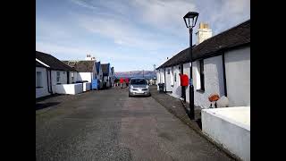
Seil Island - Scotland UK
Seil Island - Scotland UK.
Seil Island - Scotland UK.
Sea Fishing Scotland - Seil Island - Wrasse Fishing and Exploring Beautiful Island
Exploring and fishing the beautiful Seil Island I was hoping to catch ...
Exploring and fishing the beautiful Seil Island I was hoping to catch Pollock and Wrassevbut didn't manage to get to the spot I ...
Easdale Island off of Seil, Oban, Scotland
A day trip over on the foot passenger ferry. Views by drone over the ...
A day trip over on the foot passenger ferry. Views by drone over the Quarry pools and towards Mull. Filmed on DJI Spark in June ...
drone footage Seil island near oban
dji mavic pro flight seil island near oban.
dji mavic pro flight seil island near oban.
Seil Island & Easdale West Coast of Scotland
Seil Island & Easdale West Coast of Scotland.
Seil Island & Easdale West Coast of Scotland.
ELLENABEICH, Isle of seil
A walk around ELLENABEICH on the Isle of seil, Easter 2023.
A walk around ELLENABEICH on the Isle of seil, Easter 2023.
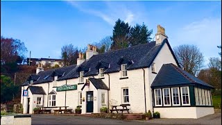
Tigh An Truish Inn, Isle of Seil, Scotland. Take a look inside…
Join us as we take a tour around Tigh An Truish. Gaelic for House of ...
Join us as we take a tour around Tigh An Truish. Gaelic for House of Trousers. Or known to the locals as The Hoose of Troosers.
RIDE OVER THE ATLANTIC BRIDGE TO SEIL ISLAND
CBF 1000.
CBF 1000.
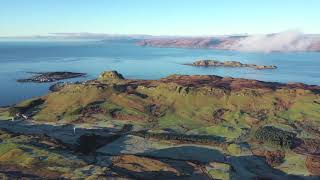
Aerial footage from Seil Island
Aerial drone footage of Seil Island, Argyll and Bute.
Aerial drone footage of Seil Island, Argyll and Bute.
Above Seil Island
Inner Hebridean Isle of Seil from a drone.
Inner Hebridean Isle of Seil from a drone.
Seil Island Drone Footage
Flying about one of the slate isles.
Flying about one of the slate isles.
Seil & Easdale Island, Argyll - Discover Scotland
Part of a series of travel guides produced by Discover Scotland. ...
Part of a series of travel guides produced by Discover Scotland. Narrated by Cora Bissett. Also available on the Discover Scotland ...
The Easdale Wall, Seil Island.
A dive in unfortunately poor visibility conditions at Rubha Mhic ...
A dive in unfortunately poor visibility conditions at Rubha Mhic Mharcuis (the Easdale Wall) on 14th September 2014, with Andrew ...
Ellenabeich, Isle of Seil and Easdale Island
April 11 2023.
April 11 2023.
Scenic Easdale Isle of Seil - Ellanbeich - Coast TV Scotland
A short film about Easdale (Ellanbeich) on the Isle of Seal on the ...
A short film about Easdale (Ellanbeich) on the Isle of Seal on the west coast of Scotlamd once famous for the quality of slate ...
Eritrea is classified as Least developed region: Countries that exhibit the lowest indicators of socioeconomic development, with the lowest Human Development Index ratings. The level of income is Low income.
News – Latest Updates and Headlines from Seil’
Stay informed with the most recent news and important headlines from Seil’. Here’s a roundup of the latest developments.
Loading...
Please note: The data used here has been primarily extracted from satellite readings. Deviations from exact values may occur, particularly regarding the height of elevations and population density. Land area and coastline measurements refer to average values at mean high tide.


![Scotland’s Least-Visited Isles – A Rainy Adventure on Slate Islands [Part 1] – Seil](https://i.ytimg.com/vi/aHL2tU8Fnhw/mqdefault.jpg)